Flin Flon is a mining city, located on a correction line on the border of the Canadian provinces of Manitoba and Saskatchewan, with the majority of the city located within Manitoba. Residents thus travel southwest into Saskatchewan, and northeast into Manitoba. The city is incorporated in and is jointly administered by both provinces.

Lloydminster is a city in Canada which has the unusual geographic distinction of straddling the provincial border between Alberta and Saskatchewan. The city is incorporated by both provinces as a single city with a single municipal administration.
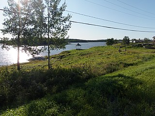
Denare Beach is a northern village on the east shore of Amisk Lake, Saskatchewan. Located on Highway 167, the community is 20 kilometres (12 mi) south-west of Flin Flon and 422 kilometres (262 mi) north-east of Prince Albert.

St. Clements is a rural municipality (RM) in Manitoba, Canada. It is located to the north-east of Winnipeg, stretching from East St. Paul and Birds Hill Provincial Park in the south to Lake Winnipeg and Grand Beach Provincial Park to the north. The Red River demarcates the western boundary of the municipality. St. Clements contains the communities of East Selkirk, and Lockport east of the Red River. It almost completely surrounds the Brokenhead 4 Indian reserve, with the exception of a small lakefront on Lake Winnipeg.

Taché is a rural municipality in Manitoba, Canada, incorporated in 1880.
Deschambault Lake, located in the Canadian province of Saskatchewan, is a small community on the shore of Deschambault Lake. The nearest city, Flin Flon, Manitoba, is 140 kilometres (90 mi) east on Highway 106. The community is at the terminus of the 31-kilometre-long (19 mi) Highway 911. Commercial fishing is the main source of income, while other employers include the Kistapiskaw School (K–12) and the local health clinic. It is part of the Peter Ballantyne Cree Nation (PBCN).

Division No. 1 is one of eighteen census divisions in the province of Saskatchewan, Canada, as defined by Statistics Canada. It is located in the southeast corner of the province, bordering Manitoba and North Dakota. The most populous community in this division is Estevan.

Division No. 5 is one of eighteen census divisions in the province of Saskatchewan, Canada, as defined by Statistics Canada. It is located in the east-southeastern part of the province, bordering Manitoba. The most populous community in this division is Melville.

Division No. 6 is one of eighteen census divisions in the province of Saskatchewan, Canada, as defined by Statistics Canada. It is located in the south-central part of the province. The most populous community in this division is Regina, the provincial capital.

Division No. 9, Canada, is one of the eighteen census divisions within the province of Saskatchewan, as defined by Statistics Canada. It is located in the eastern part of the province, bordering Manitoba. The most populous community in this division is Yorkton.

Division No. 10 is one of eighteen census divisions in the province of Saskatchewan, Canada, as defined by Statistics Canada. It is located in the east-central part of the province. The most populous community in this division is Wynyard.
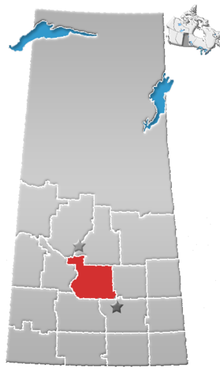
Division No. 11 is one of eighteen census divisions in the province of Saskatchewan, Canada, as defined by Statistics Canada. It is located in the central part of the province and includes the largest city in the province, Saskatoon.

Manitoba is one of Canada's 10 provinces. It is the easternmost of the three Prairie provinces.

Portage la Prairie is a rural municipality (RM) in the province of Manitoba in Western Canada. It surrounds the city of Portage la Prairie, Manitoba's fifth-largest city. Also within the borders of the municipality are the Dakota Plains First Nation and most of the Long Plain First Nation Indian reserves.
According to the 2021 census, the City of Edmonton had a population of 1,010,899 residents, compared to 4,262,635 for all of Alberta, Canada. The total population of the Edmonton census metropolitan area (CMA) was 1,418,118, making it the sixth-largest CMA in Canada.
Sandy Bay is a northern village in the boreal forest of northern Saskatchewan, Canada. It is located on the Churchill River about 70 kilometres (43 mi) north of the community of Pelican Narrows and 190 kilometres (120 mi) northwest of Creighton and Flin Flon via Highway 135 and the Hanson Lake Road. The community consists of two parts the Northern Village of Sandy Bay and the Wapaskokimaw 202 reserve of the Peter Ballantyne Cree Nation.

In the 2021 Census, the City of Calgary had a population of 1,306,784 residents, representing 30.7% of the 4,262,635 residents in all of Alberta, and 3.5% compared to a population of 36,991,981 in all of Canada. The total population of the Calgary census metropolitan area (CMA) was 1,481,806. Calgary is the largest city in Alberta, and the third-largest municipality and fifth-largest metropolitan area in Canada, as of 2021.

