Eatonia | |
|---|---|
| Town of Eatonia | |
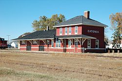 Former Canadian National Railway station in Eatonia | |
 Eatonia  Eatonia | |
| Coordinates: 51°13′16″N109°23′26″W / 51.22111°N 109.39056°W | |
| Country | Canada |
| Province | Saskatchewan |
| Census division | 8 |
| Rural Municipality | Chesterfield |
| Founded | 1919 |
| Incorporated | 1954 |
| Government | |
| • Mayor | Darcy Scott [1] |
| • Administrator | Victoria Munroe |
| • Governing body | Eatonia Town Council |
| Area | |
• Total | 1.68 km2 (0.65 sq mi) |
| Elevation | 719.6 m (2,361 ft) |
| Population (2006) | |
• Total | 449 |
| • Density | 266.6/km2 (690/sq mi) |
| Time zone | CST |
| Postal code | S0L 0Y0 |
| Area code | 306 |
| Highways | 21 and 44 |
| Airport | Eatonia (Elvie Smith) Municipal |
| Website | eatonia |
| [2] [3] | |
Eatonia is a town in the Canadian province of Saskatchewan with a population of 449 people (according to the Canada 2006 Census). [4] The town's economy is based almost exclusively on agriculture. Eatonia is in southwest Saskatchewan at the crossroads of Highways 21 and 44, approximately 44 kilometres southwest of Kindersley and 72 kilometres from the provincial boundary with Alberta. The town is served by Eatonia (Elvie Smith) Municipal Airport.


