Langham, Saskatchewan

Last updated
Langham
Town of Langham
Main Street Langham Saskatchewan.jpg
Main Street
Corman Park No. 344 Coloured Map.svg
Red pog.svg
Langham
Canada Saskatchewan location map.svg
Red pog.svg
Langham
Coordinates: 52°22′N106°58′W / 52.37°N 106.97°W / 52.37; -106.97
CountryCanada
Province Saskatchewan
Founded1904
Post office established1905-09-01
Town Incorporated1907
Government
   Mayor Gary Epp [1]
  Governing bodyLangham Town Council
Area
  Land4.27 km2 (1.65 sq mi)
Population
 (2021)
  Total1,518
  Density355.1/km2 (920/sq mi)
Time zone CST
Postal code
S0K 2L0
Area code 306
Highways Highway 16
Website Official website
[2] [3]

Langham is a town in Saskatchewan, Canada. It is located on Highway 16, 35 kilometres northwest of the city of Saskatoon. The 2011 census reported a population of 1,290, with 489 homes in the community.

Contents

Originally, the area was primarily settled by Mennonites. Langham was named after E. Langham, a purchasing agent for the Canadian National Railway. Langham was founded in 1904 with the building of a rail line between Saskatoon and Edmonton, Alberta. Langham was declared a village in 1906, and became a town in 1907.

Schools

There are two public schools serving the children of Langham and area. Approximately 150 Grades K to 5 students attend Langham Elementary School, while approximately 210 Grades 6 to 12 students attend Walter W Brown High School. Both schools are part of Prairie Spirit School Division, which includes communities that surround the city of Saskatoon. As well, 3 and 4 year olds can access a preK program at Li'l Vikings Preschool. And at the Elementary there is a before and after school program for any grade preK - 5.

Economy

The town's economy is based on commuters to the nearby city, and on agriculture. There are a number of local businesses, which include a general car maintenance and repair shop, insurance services, an autobody repair shop, a financial institution, a restaurant, daycares, gas bar, income tax services.

Entertainment and attractions

Heritage Museum and Library
in former CNR station Langham Saskatchewan Museum and Library.jpg
Heritage Museum and Library
in former CNR station

Langham is home to a branch of the Wheatland Regional Library, which is open throughout the year, offering story time programs for young children.

The Langham & District Heritage Village & Museum is open from May long weekend to September 30. The museum's purpose is to showcase and preserve the artifacts that show the history and development of Langham and District. River Valley RV Park has 31 fully serviced campsites and is located on the edge of the Town of Langham. River Ridge Trails now occupies the area of the old golf course, approx 5 km north of Langham and offers walking and biking trails and groomed ski trails in the winter. https://riverridgetrails.ca/

Activities

The Summer Activities Program occurs around town from early July until late August. Sporting, crafting, and social events happen throughout the summer. Community sport activities include hockey, curling, and figure skating in the winter, and soccer, softball, and slowpitch in the spring and summer. Langham Spray Park. The splash pad is located in Community Park and is surrounded by picnic tables, a swing set, and is beautifully landscaped. Depending on the weather and management, the Spray Park is open June – September from 10 am-8 pm

Churches

Langham offers one of the highest numbers of churches per capita in Canada. [4] Churches in Langham include the St. Mark Catholic Church, Knox United Church, Langham Mennonite Fellowship (formerly Zoar Mennonite Church), Langham Evangelical Bible Church, First Sask. Lutheran Church, and the Emmanuel Church.

Demographics

In the 2021 Census of Population conducted by Statistics Canada, Langham had a population of 1,518 living in 554 of its 589 total private dwellings, a change of 1.5% from its 2016 population of 1,496. With a land area of 4.27 km2 (1.65 sq mi), it had a population density of 355.5/km2 (920.7/sq mi) in 2021. [5]

Canada census – Langham community profile
2021 2016 2011
Population1,518 (+1.5% from 2016)1,496 (16.0% from 2011)1,290 (15.2% from 2006)
Land area4.27 km2 (1.65 sq mi)3.99 km2 (1.54 sq mi)3.98 km2 (1.54 sq mi)
Population density355.1/km2 (920/sq mi)374.9/km2 (971/sq mi)324.4/km2 (840/sq mi)
Median age35.2 (M: 35.6, F: 35.2)36.7 (M: 36.1, F: 37.3)36.3 (M: 36.1, F: 36.8)
Private dwellings589 (total)  554 (occupied)568 (total) 489 (total) 
Median household income$95,000
References: 2021 [6] 2016 [7] 2011 [8] earlier [9] [10]

Geography

Rural Saskatchewan is known for the support that communities give each other in the form of attending community activities, sharing sport teams, and building friendships among children and adults from neighboring towns and cities. Communities that surround Langham include Dalmeny, Borden, Martensville, Warman, and of course, Saskatoon. Also, Sarilia Country Estates is a new development that has been created along the Saskatchewan River approximately 6 miles north of Langham.

Grain elevator Grain Elevator Langham Saskatchewan.jpg
Grain elevator

See also

Related Research Articles

<span class="mw-page-title-main">Saskatoon</span> Largest city in Saskatchewan, Canada

Saskatoon is the largest city in the Canadian province of Saskatchewan. It straddles a bend in the South Saskatchewan River in the central region of the province. It is located along the Trans-Canada Yellowhead Highway, and has served as the cultural and economic hub of central Saskatchewan since its founding in 1882 as a Temperance colony.

<span class="mw-page-title-main">Rosthern</span> Town in Saskatchewan, Canada

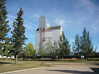
Rosthern is a town at the juncture of Highway 11 and Highway 312 in central Saskatchewan, Canada. It is located roughly halfway between the cities of Prince Albert and Saskatoon.

<span class="mw-page-title-main">Kindersley</span> Town in Saskatchewan, Canada

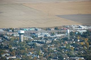
Kindersley is a town surrounded by the Rural Municipality of Kindersley No. 290 in west-central Saskatchewan, Canada. It is located along Highway 7, a primary highway linking Calgary, Alberta and Saskatoon, at its junction with Highway 21. With a population of 4,567 in 2021, it is an established industrial base for the resource-rich west-central region of the province and a service centre to the oil and gas industry and agriculture production.

<span class="mw-page-title-main">Humboldt, Saskatchewan</span> City in Saskatchewan, Canada

Humboldt is a city in the province of Saskatchewan, Canada. It is located 113 km east of Saskatoon at the junction of Highway 5 and Highway 20. The city is surrounded by the Rural Municipality of Humboldt No. 370.

<span class="mw-page-title-main">Davidson, Saskatchewan</span> Town in Saskatchewan, Canada

Davidson is a town in south central Saskatchewan, Canada. It is located 104 kilometres (65 mi) south-east of Saskatoon beside provincial highway 11 as well as Highway 44, in the rural municipality of Arm River. Located approximately halfway between Saskatoon and Regina, it is a popular stopping point with many restaurants and gas stations located adjacent to the highway.

<span class="mw-page-title-main">Dalmeny, Saskatchewan</span> Town in Saskatchewan, Canada

Dalmeny is a town in the central part of Saskatchewan, Canada, named after Dalmeny, Scotland. The town is located in the rural municipality of Corman Park, and is about 26.8 km north of Saskatoon. The Dominion Land Survey description of Dalmeny's location is Section 10 Twp 39 Rge 6 W3.

<span class="mw-page-title-main">Martensville</span> City in Saskatchewan, Canada

Martensville is a city located in Saskatchewan, Canada, just 8 kilometres (5.0 mi) north of Saskatoon, 10 kilometres (6.2 mi) west of the city of Warman and 14 kilometres (8.7 mi) southwest of Clarkboro Ferry which crosses the South Saskatchewan River. It is a bedroom community of Saskatoon. It is surrounded by the Rural Municipality of Corman Park No. 344. The community is served by the Saskatoon/Richter Field Aerodrome located immediately west of the city across Highway 12, as well as by Saskatoon's John G. Diefenbaker International Airport, only a few miles to the south.

<span class="mw-page-title-main">Outlook, Saskatchewan</span> Town in Saskatchewan, Canada

Outlook is a town in west central Saskatchewan, Canada about 80 kilometres (50 mi) south-southwest of Saskatoon. It is located along the South Saskatchewan River, downstream from Gardiner Dam and the Coteau Creek Hydroelectric Station.

<span class="mw-page-title-main">Rural Municipality of Corman Park No. 344</span> Rural municipality in Saskatchewan, Canada

The Rural Municipality of Corman Park No. 344 is a rural municipality (RM) in the Canadian province of Saskatchewan within Census Division No. 11 and SARM Division No. 5. Located in the central portion of the province, the RM surrounds the City of Saskatoon.

<span class="mw-page-title-main">Unity, Saskatchewan</span> Town in Saskatchewan, Canada

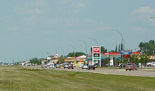
Unity is a town in the western part of the Canadian province of Saskatchewan with a population of 2573. Unity is located at the intersection of Highway 14 and Highway 21, and the intersection of the CNR and CPR main rail lines. Unity is located 200 km (125 mi) west-northwest of Saskatoon, Saskatchewan, and 375 km (235 mi) southeast of Edmonton, Alberta. The town of Wilkie is located 33 km (21 mi) to the east.

<span class="mw-page-title-main">Hague, Saskatchewan</span> Town in Saskatchewan, Canada

Hague is a small rural town in Saskatchewan, Canada, located approximately 47 kilometers north of Saskatoon. Hague was established in the late nineteenth century as a Mennonite community farming the fertile land in the area.

<span class="mw-page-title-main">Division No. 11, Saskatchewan</span> Census division of Saskatchewan, Canada

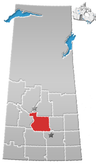
Division No. 11 is one of eighteen census divisions in the province of Saskatchewan, Canada, as defined by Statistics Canada. It is located in the central part of the province and includes the largest city in the province, Saskatoon.

<span class="mw-page-title-main">Warman, Saskatchewan</span> City in Saskatchewan, Canada

Warman (/ˈwɔrmən/) is the ninth-largest city in the province of Saskatchewan, Canada. It is located approximately 20 kilometres (12 mi) north of the city of Saskatoon, and 5 kilometres (3.1 mi) northeast of the city of Martensville. According to the 2021 census, Warman is the fastest growing municipality in Saskatchewan, and was the fastest growing municipality in Canada between 2011 and 2016. Warman is a bedroom community of Saskatoon. The current mayor is Gary Philipchuk.

<span class="mw-page-title-main">Meadowgreen, Saskatoon</span> Neighborhood in Saskatoon, Saskatchewan, Canada

Meadowgreen is a neighbourhood located on the west side of the city in the Confederation Suburban Development Area in the city of Saskatoon, Saskatchewan, Canada. Meadowgreen is surrounded by an abundance of green space and walking trails without being a River side neighbourhood. The buffer zone along Circle Drive has a newly created walking trail. The southern buffer zone along 11th Street connects to the east with Fred Mendel Park of the Pleasant Hill neighbourhood and to the west with the off leash dog run located in the Confederation Suburban Centre neighbourhood. As well the newly re-located Meadowgreen Park and Peter Pond Park provide leisure activities such as basketball courts and playgrounds. Within the Confederation SDA of Saskatoon, the neighborhood of Meadowgreen comprises the area south of 22nd Street, north of the buffer zone between 11th Street and Appleby Drive, east of Circle Drive, and west of Avenue W South. Until the 1990s the portion of the community north of 18th Street was considered part of the Pleasant Hill community until the City of Saskatoon reorganized its community boundaries.

<span class="mw-page-title-main">Waldheim, Saskatchewan</span> Town in Saskatchewan, Canada

Waldheim is a town of 1,035 residents in the Rural Municipality of Laird No. 404, in the Canadian province of Saskatchewan, 57 kilometres (35 mi) north of Saskatoon. Waldheim is located on Highway 312 in central Saskatchewan, the "Heart of the Old North-Wes". Fort Carlton, Batoche, Battle of Fish Creek, and Seager Wheeler's Maple Grove Farm are all near Waldheim.

<span class="mw-page-title-main">Kelvington, Saskatchewan</span> Town in Saskatchewan, Canada

Kelvington is a town of 864 residents in the rural municipality of Kelvington No. 366, in the Canadian province of Saskatchewan. Kelvington is located at the intersection of Highway 38 and Highway 49. It is east of Saskatoon.

<span class="mw-page-title-main">Dundurn, Saskatchewan</span> Town in Saskatchewan, Canada

Dundurn is a town of 647 residents surrounded by the RM of Dundurn No. 314, in the Canadian province of Saskatchewan. Dundurn is located on Highway 11, or Louis Riel Trail, in central Saskatchewan, about 42 km south of Saskatoon. As well as being an agricultural town, it is a bedroom community for both Saskatoon and Canadian Forces Detachment Dundurn, which is located 6 kilometres (4 mi) north of town and is a detachment of 17 Wing Winnipeg.

<span class="mw-page-title-main">Vonda, Saskatchewan</span> Town in Saskatchewan, Canada

Vonda is located on Highway 27, a half-hour drive north east of Saskatoon, Saskatchewan. The town was named after the daughter of American journalist Cy Warman.

<span class="mw-page-title-main">Osler, Saskatchewan</span> Town in Saskatchewan, Canada

<span class="mw-page-title-main">Rural Municipality of Rosthern No. 403</span> Rural municipality in Saskatchewan, Canada

The Rural Municipality of Rosthern No. 403 is a rural municipality (RM) in the Canadian province of Saskatchewan within Census Division No. 15 and SARM Division No. 5. It is located in the central portion of the province north of the City of Saskatoon.

References

  1. "Municipal Directory System".
  2. National Archives, Archivia Net. "Post Offices and Postmasters". Archived from the original on 2006-10-06. Retrieved 2014-08-21.
  3. Government of Saskatchewan, MRD Home. "Municipal Directory System". Archived from the original on 2016-01-15. Retrieved 2014-08-21.
  4. "Information & Resources for Residents | Town of Langham". langham.ca. Retrieved 2017-06-05.
  5. "Population and dwelling counts: Canada, provinces and territories, census divisions and census subdivisions (municipalities), Saskatchewan". Statistics Canada. February 9, 2022. Retrieved April 1, 2022.
  6. "2021 Community Profiles". 2021 Canadian Census . Statistics Canada. February 4, 2022. Retrieved 2023-10-19.
  7. "2016 Community Profiles". 2016 Canadian Census . Statistics Canada. August 12, 2021. Retrieved 2017-06-05.
  8. "2011 Community Profiles". 2011 Canadian Census . Statistics Canada. March 21, 2019. Retrieved 2014-04-24.
  9. "2006 Community Profiles". 2006 Canadian Census . Statistics Canada. August 20, 2019.
  10. "2001 Community Profiles". 2001 Canadian Census . Statistics Canada. July 18, 2021.

52°22′N106°58′W / 52.367°N 106.967°W / 52.367; -106.967 (Langham, Saskatchewan)