
The Cree are a North American Indigenous people. They live primarily in Canada, where they form one of the country's largest First Nations.

The Chipewyan are a Dene Indigenous Canadian people of the Athabaskan language family, whose ancestors are identified with the Taltheilei Shale archaeological tradition. They are part of the Northern Athabascan group of peoples, and come from what is now Western Canada.

The Flying Dust First Nation is a Cree First Nation band government located adjacent to the city of Meadow Lake in Saskatchewan, Canada. Highway 55 goes through the band's reserve community.
Patuanak is a community in northern Saskatchewan, Canada. It is the administrative headquarters of the Dene First Nations reserve near Churchill River and the north end of Lac Île-à-la-Crosse. In Dene, it sounds similar to Boni Cheri (Bëghą́nı̨ch’ërë).
Waterhen Lake First Nation is a Cree First Nation band government located in northwestern Saskatchewan, Canada. As of October 2018 the total membership of the Waterhen Lake First Nation was 2,053. There were 983 members living on reserve, 2 on Crown Land and 1,068 members living off reserve. The First Nation is a member of the MLTC Program Services, a regional tribal Chiefs' Council. The First Nation is also a signatory to the Adhesion to Treaty 6 in 1921.
Turnor Lake is a community on the southern shore of Turnor Lake. From Highway 155 it is accessible by Highway 909. The community includes the Northern Hamlet of Turnor Lake and Turnor Lake 193B of the Birch Narrows First Nation.
The Meadow Lake Tribal Council (MLTC) is a tribal council representing nine First Nation band governments in the province of Saskatchewan. The council is based in Meadow Lake, Saskatchewan.
Pelican Lake First Nation is a member of the Federation of Saskatchewan First Nations, the body that represents 74 First Nations in Saskatchewan.
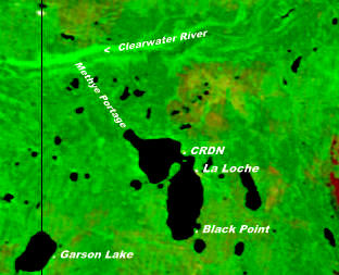
The Clearwater River Dene Nation is a Dene First Nations band government in the boreal forest area of northern Saskatchewan, Canada. It maintains offices in the village of Clearwater River situated on the eastern shore of Lac La Loche. The Clearwater River Dene Nation reserve of Clearwater River shares its southern border with the village of La Loche.

The Buffalo River Dene Nation is a Dene First Nations band government in Saskatchewan, Canada. The band's main community, Dillon, is located on the western shore of Peter Pond Lake at the mouth of the Dillon River, and is accessed by Highway 925 from Highway 155.

The English River Dene Nation is a Dene First Nation band government in Patuanak, Saskatchewan, Canada. Their reserve is in the northern section of the province. Its territories are in the boreal forest of the Canadian Shield. This First Nation is a member of the Meadow Lake Tribal Council (MLTC).
The Prince Albert Grand Council (PAGC) is a Tribal Council representing the band governments of twelve First Nations in the province of Saskatchewan. Its head offices are located in the city of Prince Albert. The Tribal Council was created in 1977 and is one of the largest in Canada.

Birch Narrows Dene Nation is a Dene First Nation band government in the boreal forest region of northern Saskatchewan, Canada. It is affiliated with the Meadow Lake Tribal Council (MLTC).
The Shoal Lake Cree Nation is a Swampy Cree First Nations band government in Saskatchewan, Canada located 98 kilometres (61 mi) east of Nipawin. The Cree First Nation is on the Carrot River and can be accessed by Highway 55. Nearby to the west is the Red Earth First Nation.

Red Earth Cree Nation is a Cree community in Saskatchewan, Canada. It is located 225 kilometres (140 mi) northeast of Prince Albert. The main settlement of Red Earth is located on the Carrot River and accessed by Highway 55. Nearby to the east is the Shoal Lake First Nation.

Peepeekisis Cree Nation (Cree: ᐲᐦᐲᑭᓰᐢ, pîhpîkisîs, literal meaning: Sparrow Hawk) is a Cree First Nation in southern Saskatchewan, Canada. Its reserves include Peepeekisis 81; Treaty Four Reserve Grounds 77, which is shared with 32 other bands; and Peepeekisis Cree Nation, which is located 19 km (12 mi) east of Balcarres, Saskatchewan, on Highway 10.
Canoe Lake Cree First Nation is a Cree First Nation based in the settlement of Canoe Narrows, Saskatchewan. The Nation is a member of Meadow Lake Tribal Council Tribal Council.

Canoe Lake 165A is an Indian reserve of the Canoe Lake Cree First Nation in Saskatchewan. It is 30 miles southwest of Île-à-la-Crosse.

Canoe Lake 165B is an Indian reserve of the Canoe Lake Cree First Nation in Saskatchewan. It is 22 miles southwest of Île-à-la-Crosse.
Eagles Lake 165C is an Indian reserve of the Canoe Lake Cree First Nation in Saskatchewan. It consists of all that portion of Township 59, Range 14, west of the Third Meridian. In the 2016 Canadian Census, it recorded a population of 92 living in 29 of its 32 total private dwellings. In the same year, its Community Well-Being index was calculated at 72 of 100, compared to 58.4 for the average First Nations community and 77.5 for the average non-Indigenous community.

