Treaty 2

Last updated

Treaty 2 was entered in to on 21 August 1872 at Manitoba House, Rupertsland, with representatives of the Queen of Great Britain and Ireland. The original Anishinaabe (Chippewa and Cree), who were present, constitute Treaty 2 today. It is known that many of the chiefs and leaders within the territory were at the early gathering and after the treaty was agreed to. Those who were not present were represented through Metis until they indicated where they wished their farming reserves to be established. The treaty reaffirmed the inherent rights that the Anishinaabe had prior to European contact, located where southwestern Manitoba is today and a small part of southeastern Saskatchewan.

Contents

History

This was the second treaty made since the formation of the modern Canadian government in 1867, and one year after the province Manitoba joined the Canadian Confederation. Manitoba was not a province located in Treaty 2 at the time the treaty was made. The Manitoba Act was amended in 1872 to accommodate Treaty 1.

The purpose of Treaty 2 21 August 1871 "….to open up to settlement and immigration a tract of country bounded and described hereinafter mentioned, and to obtain the consent thereto of her Indian subjects inhabiting the said tract, and to make treaty and arrangements with them, so that there be peace and good will…"

It was also known as the "Manitoba Post Treaty," named after the fur trading post of the Hudson's Bay Company where the treaty was signed. Manitoba Post was located on the northwest shore of Lake Manitoba. The terms of this treaty were similar to that of Treaty 1. [1]

Treaty 1 and Treaty 2 were amended by an Order in Council on 30 April 1875, to add provisions which were originally promised verbally by the government. Similar "outside promises" were included in the text of 1873's Treaty 3, adding further pressure on the government to include such provisions in the earlier treaties.

Treaty 2 itself notes that there were several communities who were not represented at Manitoba House, and in the Treaty, it provides that Mekis, a son of Okanese, would represent those communities in the Treaty 2 process.

←===The Treaty 2 territory===

The Anishinaabe/Chippawa territory is much larger and extends beyond the current territory of Treaty 2. Today going by the original text during the making of Treaty 2 extends north of Treaty No.1 territory, along the east shore of Lake Winnipeg to Berens River, across to the Dauphin River along the waterways up to the northern tip of Waterhen Lake, across the Winnipegosis north of Duck Bay (old Duck Bay Reserve), then to the source of the Shell River in Duck Mountains along the Assiniboine to the Moose Mountains in southeastern Saskatchewan across the international border up by Brandon then to white mud river across over to the Drunken River, then to Winnipeg River where it started.

The territory includes 8,676,828 hectares of land (21,440,909 acres). Included within the territory are many mountains, rivers, and lakes which include; Riding Mountain National Park, Duck Mountain Provincial Park, Turtle Mountain Provincial Park, Hecla/ Grindstone Provincial Park, and Moose Mountain Provincial Park Saskatchewan, and many lakes such as Dauphin Lake, Clear Lake, Childs Lake, south basin of Lake Winnipegosis and Lake Winnipeg and north basin of Lake Manitoba. Today's largest city located in Treaty 2 is Brandon, then Dauphin. There are many towns and RMs located within the territory today.

List of Treaty 2 First Nations

See also

Related Research Articles

<span class="mw-page-title-main">Lake Winnipeg</span> Large glacial lake in Manitoba, Canada

Lake Winnipeg is a very large, relatively shallow 24,514-square-kilometre (9,465 sq mi) lake in North America, in the province of Manitoba, Canada. Its southern end is about 55 kilometres (34 mi) north of the city of Winnipeg. Lake Winnipeg is Canada's sixth-largest freshwater lake and the third-largest freshwater lake contained entirely within Canada, but it is relatively shallow excluding a narrow 36 m (118 ft) deep channel between the northern and southern basins. It is the eleventh-largest freshwater lake on Earth. The lake's east side has pristine boreal forests and rivers that were in 2018 inscribed as Pimachiowin Aki, a UNESCO World Heritage Site. The lake is 416 km (258 mi) from north to south, with remote sandy beaches, large limestone cliffs, and many bat caves in some areas. Manitoba Hydro uses the lake as one of the largest reservoirs in the world. There are many islands, most of them undeveloped.

<span class="mw-page-title-main">Lake Manitoba</span> Lake in Manitoba, Canada

Lake Manitoba is the 14th largest lake in Canada and the 33rd largest lake in the world with a total area of 4,624 square kilometres (1,785 sq mi). It is located within the Canadian province of Manitoba about 75 kilometres (47 mi) northwest of the province's capital, Winnipeg, at 50°59′N98°48′W.

<span class="mw-page-title-main">Lake Winnipegosis</span> Glacial lake in Manitoba, Canada

Lake Winnipegosis is a large (5,370 km2) lake in central North America, in Manitoba, Canada, some 300 km northwest of Winnipeg. It is Canada's eleventh-largest lake.

<span class="mw-page-title-main">Saulteaux</span> Westernmost branch of the Anishinaabe people

The Saulteaux, otherwise known as the Plains Ojibwe, are a First Nations band government in Ontario, Manitoba, Saskatchewan, Alberta and British Columbia, Canada. They are a branch of the Ojibwe who pushed west. They formed a mixed culture of woodlands and plains Indigenous customs and traditions.

<span class="mw-page-title-main">Lake of the Woods</span> Lake on the United States–Canada border

Lake of the Woods is a lake occupying parts of the Canadian provinces of Ontario and Manitoba and the U.S. state of Minnesota. Lake of the Woods is over 70 miles (110 km) long and wide, containing more than 14,552 islands and 65,000 miles (105,000 km) of shoreline. It is fed by the Rainy River, Shoal Lake, Kakagi Lake and other smaller rivers. The lake drains into the Winnipeg River and then into Lake Winnipeg. Ultimately, its outflow goes north through the Nelson River to Hudson Bay.

<span class="mw-page-title-main">Winnipeg River</span> River in the Canadian provinces of Manitoba and Ontario

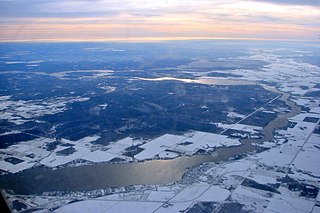
Winnipeg River is a Canadian river that flows roughly northwest from Lake of the Woods in the province of Ontario to Lake Winnipeg in Manitoba. This river is 235 kilometres (146 mi) long from the Norman Dam in Kenora to its mouth at Lake Winnipeg. Its watershed is 106,500 square kilometres (41,100 sq mi) in area, mainly in Canada. About 29,000 square kilometres (11,000 sq mi) of the watershed is in northern Minnesota, United States.

<span class="mw-page-title-main">Parkland Region</span> Region of Manitoba in Canada

Parkland is an informal geographic region of the Canadian province of Manitoba, located between Lakes Manitoba and Winnipegosis on the east and the Manitoba–Saskatchewan border on the west.

The Pine Creek First Nation is a Saulteaux First Nation in Manitoba, Canada. The First Nation's homeland is the Pine Creek 66A reserve, located approximately 110 kilometres north of Dauphin along the southwestern shore of Lake Winnipegosis between the communities of Camperville and Duck Bay. The Rural Municipality of Mountain (South) borders it on the southwest.

<span class="mw-page-title-main">Geography of Manitoba</span>

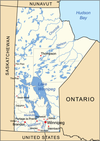
The geography of Manitoba addresses the easternmost of the three prairie Canadian provinces, located in the longitudinal centre of Canada. Manitoba borders on Saskatchewan to the west, Ontario to the east, Nunavut to the north, and the American states of North Dakota and Minnesota to the south. Although the border with Saskatchewan appears straight on large-scale maps, it actually has many right-angle corners that give the appearance of a slanted line. In elevation, Manitoba ranges from sea level on Hudson Bay to 2727 ft (831 m) on top of Baldy Mountain. The northern sixty percent of the province is on the Canadian Shield. The northernmost regions of Manitoba lie permafrost, and a section of tundra bordering Hudson Bay.

The Manitoba Escarpment, or the Western Manitoba Uplands, are a range of hills along the Saskatchewan-Manitoba border. The eastern slopes of the range are considered to be a scarp. They were created by glacial scouring and formed the western shore of prehistoric Lake Agassiz.

<span class="mw-page-title-main">Division No. 19, Manitoba</span> Census division in Manitoba, Canada

Division No. 19, also informally known as North East Manitoba, is a census division within the Province of Manitoba, Canada. Unlike in some other provinces, census divisions do not reflect the organization of local government in Manitoba. These areas exist solely for the purposes of statistical analysis and presentation; they have no government of their own.

<span class="mw-page-title-main">Boreal Plains Ecozone (CEC)</span> An ecozone

The Boreal Plains Ecozone, as defined by the Commission for Environmental Cooperation (CEC), is a terrestrial ecozone in the western Canadian provinces of Manitoba, Saskatchewan and Alberta. It also has minor extensions into northeastern British Columbia and south-central Northwest Territories. The region extends over 779,471 km2, of which 58,981 km2 is conserved.

Skownan First Nation is a Saulteaux (Ojibwe) First Nations band government whose reserve community, Waterhen 45, is located 288 km north of Winnipeg, Manitoba, Canada, on the south shore of Waterhen Lake, between Lake Winnipeg and Lake Winnipegosis. As of May, 2015, the First Nation had 1,464 registered members, of which 750 lived on-reserve.

The Manitoba Watershed District Program is a provincial-municipal partnership directed to the conservation and management of water and soil resources. There are 14 watershed districts including more than 130 municipalities covering almost all of the agricultural areas of Manitoba, Canada. The Province provides substantial funding and general guidance but the programs are developed and administered locally. The districts spend more than $8 million each year on a wide variety of conservation programs.

The Prairie Mountain Health is the governing body responsible for healthcare delivery and regulation for the eponymous health region in southwest Manitoba.

Lake Manitoba Railway and Canal Company (LMR) was a historic rail line in Manitoba, Canada, between Gladstone in the south and Winnipegosis to its north.

<span class="mw-page-title-main">Waterhen Lake (Manitoba)</span> Lake in Manitoba, Canada

Waterhen Lake is a lake in Manitoba, Canada, located about 300 km north of the provincial capital of Winnipeg, between Lake Winnipeg and Lake Winnipegosis.

Birch Island Provincial Park is a remote provincial park located on Lake Winnipegosis in Manitoba, Canada. The park is bordered on its western boundary by the Swan-Pelican Provincial Forest and on its eastern side by Chitek Lake Anishinaabe Provincial Park.

References

  1. "Numbered Treaty Overview". Canada in the Making. Canadiana.org (Formerly Canadian Institute for Historical Microreproductions). Archived from the original on 9 April 2004. Retrieved 16 November 2009. On a memorandum dated 27th April, 1875, from the Honourable the Minister of the Interior, bringing under consideration the very unsatisfactory state of affairs arising out of the so-called "outside promises" in connection with the Indian Treaties Nos. 1 and 2, Manitoba and North-west Territories, concluded, the former on the 3rd August, 1871, and the latter on 21st of the same month, and recommending for the reasons