Hanna, Alberta

Last updated

Hanna
Town
Town of Hanna
Hanna Alberta welcome sign.jpg
4640 Special Areas No 2, Alberta, Detailed.svg
Red pog.svg
Hanna
Alberta County Point Locator.svg
Red pog.svg
Hanna
Coordinates: 51°38′18″N111°56′31″W / 51.63833°N 111.94194°W / 51.63833; -111.94194
CountryCanada
Province Alberta
Region Southern Alberta
Census division 4
Special Area Special Area No. 2
Incorporated [1]  
   Village December 31, 1912
   Town April 14, 1914
Government
  MayorDanny Povaschuk
  Governing bodyHanna Town Council
Area
 (2021) [4]
  Land8.4 km2 (3.2 sq mi)
Elevation
[5]
785 m (2,575 ft)
Population
 (2021) [4] [6]
  Total2,394
  Density285.1/km2 (738/sq mi)
Time zone UTC−7 (MST)
  Summer (DST) UTC−6 (MDT)
Postal code span
Area code 403, 587, 825
Highway Highway 9
Website www.hanna.ca

Hanna is a town in Central Alberta, Canada.

History

The town was first settled in 1912 and was incorporated in 1914. It was named after David Blyth Hanna, the third vice president of the Canadian Northern Railway. It was a division point of the Canadian Northern Railway and had a 10-stall railway roundhouse. [7]

Contents

Demographics

In the 2021 Census of Population conducted by Statistics Canada, the Town of Hanna had a population of 2,394 living in 1,100 of its 1,257 total private dwellings, a change of

In the 2016 Census of Population conducted by Statistics Canada, the Town of Hanna recorded a population of 2,559 living in 1,149 of its 1,246 total private dwellings, a

Economy

The town's main industries are agriculture, oil production, power generation, tourism, and coal mining. It is the centre of a large trading area called Short Grass County and is the home of approximately 200 businesses. [9] Natural resources in the Hanna area are coal, petroleum, natural gas, and bentonite. [7]

Notable people

Sister town

Related Research Articles

<span class="mw-page-title-main">Turner Valley</span> Former town in Alberta, Canada

Turner Valley was a town in the Calgary Metropolitan Region of Alberta, Canada within the Town of Diamond Valley. It is on Highway 22, 3 km (1.9 mi) west of Black Diamond and approximately 60 km (37 mi) southwest of Calgary. It was named after Robert and John Turner who settled in the area in 1886.

<span class="mw-page-title-main">Elk Point, Alberta</span> Town in Alberta, Canada

Elk Point is a town located in Eastern Alberta, Canada. It is located on Highway 41.

<span class="mw-page-title-main">Bonnyville</span> Town in Alberta, Canada

Bonnyville is a town situated in East Northern Alberta, Canada between Cold Lake and St. Paul. The Municipal District (MD) of Bonnyville No. 87's surrounds the Town.

<span class="mw-page-title-main">Stettler, Alberta</span> Town in Alberta, Canada

Stettler is a town in east-central Alberta, Canada that is surrounded by the County of Stettler No. 6. The town is nicknamed "The Heart of Alberta".

<span class="mw-page-title-main">Mayerthorpe</span> Town in Alberta, Canada

Mayerthorpe is a town in central Alberta, Canada. It is approximately 120 km (75 mi) northwest of Edmonton at the intersection of Highway 43 and Highway 22. The town is surrounded by Lac Ste. Anne County and is in Alberta's Census Division No. 13.

<span class="mw-page-title-main">Consort, Alberta</span> Village in Alberta, Canada

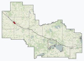
Consort is a village in eastern Alberta, Canada. It is located at the intersection of Highway 12 and Highway 41, approximately 250 km southeast of Edmonton, 252 km northeast of Calgary, and 283 km west of Saskatoon. The Saskatchewan border is approximately 60 km to the east.

<span class="mw-page-title-main">Viking, Alberta</span> Town in Alberta, Canada

Viking is a town in central Alberta, Canada. It is at the intersection of Highway 14 and Highway 36, approximately 121 km (75 mi) east of Edmonton.

<span class="mw-page-title-main">Ponoka, Alberta</span> Town in Alberta, Canada

Ponoka is a town in central Alberta, Canada. It is located at the junction of Highway 2A and Highway 53, 59 kilometres (37 mi) north of Red Deer and 95 kilometres (59 mi) south of Edmonton.

<span class="mw-page-title-main">Mannville, Alberta</span> Village in Alberta, Canada, incorporated 1906

Mannville is a village in central Alberta, Canada. It is located at the intersection of the Yellowhead Highway and Highway 881, approximately 22 kilometres (14 mi) west of Vermilion and 170 kilometres (110 mi) east of Edmonton. Its primary industry is agriculture.

<span class="mw-page-title-main">Daysland</span> Town in Alberta, Canada

Daysland is a town in central Alberta, Canada. It is on Highway 13, approximately 43 kilometres (27 mi) east of Camrose.

<span class="mw-page-title-main">Grande Cache</span> Hamlet in Alberta, Canada

Grande Cache is a hamlet in West-Central Alberta, Canada within and administered by the Municipal District of Greenview No. 16. It is located on Highway 40 approximately 145 kilometres (90 mi) northwest of Hinton and 435 kilometres (270 mi) west of Edmonton. Grande Cache overlooks the Smoky River, is at the northern edge of Alberta's Rockies, and serves as a gateway to the Willmore Wilderness Park. The hamlet held town status prior to 2019.

<span class="mw-page-title-main">Innisfail, Alberta</span> Town in Alberta, Canada

Innisfail is a town in central Alberta, Canada. It is located in the Calgary-Edmonton Corridor, south of Red Deer at the junction of Highway 2 and Highway 54.

<span class="mw-page-title-main">Killam, Alberta</span> Town in Alberta, Canada

Killam is a town in central Alberta, Canada. It is located in Flagstaff County, east of Camrose at the junction of Highway 13 and Veterans Memorial Highway, Highway 36. Killam is located in a rich agricultural area and is a local hub for trade. It is considered the agricultural hub of Flagstaff County.

<span class="mw-page-title-main">Provost, Alberta</span> Town in Alberta, Canada

Provost is a town in central Alberta, Canada. It is located at the junction of Highway 13 and Highway 899, 19 km (12 mi) west of the Alberta-Saskatchewan border. It was originally named "Lakeview" but renamed by the Canadian Pacific Railway Land Department in 1907; the first train to the town was in 1910. Post office established in 1908.

<span class="mw-page-title-main">Smoky Lake</span> Town in Alberta, Canada

Smoky Lake is a town in central Alberta, Canada. It is located 116 km (72 mi) northeast of Edmonton at the junction of Highway 28 and Highway 855. It lies between the North Saskatchewan River, Smoky Creek, and White Earth Creek, in a mainly agricultural area. The provincial historic site of Victoria Settlement is nearby. Long Lake Provincial Park is located 60 km (37 mi) north of the town. The Woods Cree, a First Nations people, named "Smoking Lake" for the smoke from ceremonies performed on the shore; the name Smoky Lake may also be based in the mist that rose from the lake in great quantities at sundown. One of its churches, the St. Onuphrius Ukrainian-Catholic, built in 1907, has been moved to the Canadian Museum of History in Gatineau, Quebec. It is in Census Division No. 12 and is the municipal office for the Smoky Lake County.

<span class="mw-page-title-main">Caroline, Alberta</span> Village in Alberta, Canada

Caroline is a village in central Alberta, Canada. It is located southwest of Red Deer.

<span class="mw-page-title-main">Starland County</span> Municipal district in Alberta, Canada

Starland County is a municipal district located in southern Alberta, Canada.

Indus is a hamlet in southern Alberta, Canada under the jurisdiction of Rocky View County. It is home to the Bill Herron Arena

<span class="mw-page-title-main">Blackie, Alberta</span> Hamlet in Alberta, Canada

Blackie is a hamlet in Alberta, Canada within the Foothills County. It is located approximately 70 kilometres (43 mi) southeast of Calgary on Highway 799.

Dapp is a hamlet in central Alberta, Canada within Westlock County. It is located 4 kilometres (2.5 mi) west of Highway 44, approximately 81 kilometres (50 mi) northwest of St. Albert.

References

  1. "Location and History Profile: Town of Hanna" (PDF). Alberta Municipal Affairs. October 7, 2016. p. 295. Retrieved October 13, 2016.
  2. "Municipal Officials Search". Alberta Municipal Affairs. May 9, 2019. Retrieved October 1, 2021.
  3. Irwin, Jackie (September 27, 2021). "Povaschuk elected by acclimation". Hanna Herald. Postmedia. Retrieved May 1, 2022.
  4. 1 2 3 "Population and dwelling counts: Canada, provinces and territories, and census subdivisions (municipalities)". Statistics Canada. February 9, 2022. Retrieved February 9, 2022.
  5. "Alberta Private Sewage Systems 2009 Standard of Practice Handbook: Appendix A.3 Alberta Design Data (A.3.A. Alberta Climate Design Data by Town)" (PDF) (PDF). Safety Codes Council. January 2012. pp. 212–215 (PDF pages 226–229). Archived from the original (PDF) on October 16, 2013. Retrieved October 8, 2013.
  6. "Population and dwelling counts: Canada and population centres". Statistics Canada. February 9, 2022. Retrieved February 13, 2022.
  7. 1 2 Pannekoek, Frits. "Hanna". The Canadian Encyclopedia . Retrieved November 9, 2022.
  8. "Population and dwelling counts, for Canada, provinces and territories, and census subdivisions (municipalities), 2016 and 2011 censuses – 100% data (Alberta)". Statistics Canada. February 8, 2017. Retrieved February 8, 2017.
  9. "Business Listings | Hanna, Alberta" . Retrieved November 30, 2021.