
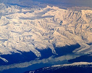
Mount Logan is the highest mountain in Canada and the second-highest peak in North America after Denali. The mountain was named after Sir William Edmond Logan, a Canadian geologist and founder of the Geological Survey of Canada (GSC). Mount Logan is located within Kluane National Park Reserve in southwestern Yukon, less than 40 km (25 mi) north of the Yukon–Alaska border. Mount Logan is the source of the Hubbard and Logan glaciers. Although many shield volcanoes are much larger in size and mass, Mount Logan is believed to have the largest base circumference of any non-volcanic mountain on Earth, including a massif with eleven peaks over 5,000 m (16,000 ft).

Denali is the highest mountain peak in North America, with a summit elevation of 20,310 feet (6,190 m) above sea level. It is the tallest mountain in the world from base-to-peak on land, measuring 18,000 ft (5,500 m), and Earth's highest mountain north of 43°N. With a topographic prominence of 20,194 feet (6,155 m) and a topographic isolation of 4,621.1 miles (7,436.9 km), Denali is the third most prominent and third-most isolated peak on Earth, after Mount Everest and Aconcagua. Located in the Alaska Range in the interior of the U.S. state of Alaska, Denali is the centerpiece of Denali National Park and Preserve.

Mount Saint Elias, the second-highest mountain in both Canada and the United States, stands on the Yukon and Alaska border about 26 miles (42 km) southwest of Mount Logan, the highest mountain in Canada. The Canadian side of Mount Saint Elias forms part of Kluane National Park and Reserve, while the U.S. side of the mountain is located within Wrangell-St. Elias National Park and Preserve.

Mount Steele is the fifth-highest mountain in Canada and either the tenth- or eleventh-highest peak in North America. Its exact elevation is uncertain. Commonly-quoted figures are 5,073 metres (16,644 ft) and 5,020 metres (16,470 ft). A lower southeast peak of Mt. Steele stands at 4,300 m (14,100 ft).

Mount Kennedy is a peak in the Saint Elias Mountains within Kluane National Park, in Yukon, Canada. Its 4250-m to 4300-m (14000-foot) summit lies within 10 km of the Alaska Panhandle. Dusty Glacier lies against it to the north.

Mount Sanford is a shield volcano in the Wrangell Volcanic Field, in eastern Alaska near the Copper River. It is the sixth highest mountain in the United States and the third highest volcano behind Mount Bona and Mount Blackburn. The south face of the volcano, at the head of the Sanford Glacier, rises 8,000 feet (2,400 m) in 1 mile (1,600 m) resulting in one of the steepest gradients in North America.
Henry Bradford Washburn Jr. was an American explorer, mountaineer, photographer, and cartographer. He established the Boston Museum of Science, served as its director from 1939–1980, and from 1985 until his death served as its Honorary Director. Bradford married Barbara Polk in 1940, they honeymooned in Alaska making the first ascent of Mount Bertha together.

Mount Crillon is a high peak of the Fairweather Range, the southernmost part of the Saint Elias Mountains. It lies southeast of Mount Fairweather, in the promontory between the Gulf of Alaska and Glacier Bay. It is included in Glacier Bay National Park. The peak was named after Felix-Francois-Dorothee de Bretton, Comte de Crillon, by his friend, the French explorer Jean Francois de Galaup de la Perouse.
Mount Marcus Baker is the highest peak of the Chugach Mountains of Alaska. It is located approximately 75 miles (121 km) east of Anchorage. This peak is very prominent because of its proximity to tidewater and is only 12 miles (19 km) north of the calving face of Harvard Glacier. Mount Marcus Baker is ranked 67th in the world when measured by topographic prominence.

Mount Bear is a high, glaciated peak in the Saint Elias Mountains of Alaska. It lies within Wrangell-Saint Elias National Park, about 4 miles (6.4 km) west of the Yukon border. The Barnard Glacier flows from its southwest slopes, while the Klutlan Glacier lies to the north. Its principal claim to fame is that it is a fourteener, and in fact one of the highest 20 peaks in the United States.
Terris Moore was an explorer, mountaineer, light plane pilot, and the second president of the University of Alaska.
This article comprises three sortable tables of major mountain peaks of Canada.
Robert Hicks Bates was an American mountaineer, author and teacher, who is best remembered for his parts in the first ascent of Mount Lucania and the American 1938 expedition and 1953 expedition to K2.
The Centennial Range is a sub-range of the Saint Elias Mountains. It is located inside Kluane National Park and Reserve in the far west of Yukon Territory in Canada. It consists of fourteen major peaks, and was named for Canada's Centennial in 1967. Its peaks bear the names of Canada's provinces and territories, with the exception of Nunavut, which was not a territory at the time. The tallest point is Centennial Peak. Nine of the peaks were climbed as part of the Yukon Alpine Centennial Expedition, part of the 1967 celebrations.
Vernon "Vern" Tejas is an American mountain climber and mountain guide. He is the current world record holder in the amount of time taken to summit all of the Seven Summits consecutively, having also previously held the same record. He was also the first person to solo summit several of the world's tallest peaks. Tejas was named one of the top fifty Alaskan athletes of the twentieth century by Sports Illustrated in 2002. In 2012, he was elected to the Alaska Sports Hall of Fame. Tejas plays the harmonica and guitar. He currently resides in Greenwich Village, New York.

Donald Kenneth Morrison was a British climber and mountaineer. Morrison first became known as a pioneer rock climber in Canada, then in England's Peak District and he led three expeditions to the Himalayas. He died in 1977 leading an attempt on Latok II peak in the Karakoram.

Mount Bertha is a 10,204-foot glaciated mountain summit located in the Fairweather Range of the Saint Elias Mountains, in southeast Alaska, United States.

