Pabay

Last updated

Pabay
Scottish Gaelic namePabaigh
Old Norse namePapey
Meaning of nameIsland of the papar
Location
Isle of Skye UK relief location map.jpg
Red pog.svg
Pabay
Pabay shown relative to Skye
OS grid reference NG674271
Coordinates 57°17′N5°52′W / 57.28°N 5.86°W / 57.28; -5.86
Physical geography
Island group Isle of Skye
Area122 ha (12 sq mi)
Area rank136 [1]
Highest elevation28 m (92 ft)
Administration
Sovereign state United Kingdom
Country Scotland
Council area Highland
Demographics
Population0
Lymphad3.svg
References [2] [3] [4]

Pabay is a Scottish island just off the coast of Skye. The name Pabay is derived from an old Norse word meaning "priest's isle" and there are the remains of a 13th-century chapel.

Contents

Geography

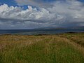
Pabay is an island in the Inner Sound of Skye, lying 2+12 miles (4 kilometres) north of Broadford. It lies south of Longay and east of the larger Scalpay. [5] Like most others of the name, is a low grassy island. It is 360 acres (150 hectares) in size, diamond-shaped and predominantly flat. The highest point is 28 metres (92 feet) above sea level, with cliffs on the North and East shores.

The island is formed of fossil-containing limestone, with some micaceous shale, named Pabba Shale. [6] It forms a flat plateau with cliffs on the North and East shores. The surrounding low reefs encroach on its shores and double the area at low water. [6]

The island gives its name to a group of Jurassic Sedimentary rocks which are seen across the Inner Hebredian area-Pabba Shales. These were laid down at the bottom of a muddy sea 190 million years ago. Much later (about 60 million years ago) volcanicity associated with the opening of the Atlantic Ocean led to the intrusion of molten rock along fractures running NNW-SSE across the island. The resulting dykes now stand proud as solid sheets resembling well built masonry and protecting the island from further erosion.

History

Occupation of the island, in the form of midden material and lithics found in two locations, can be traced back to the prehistoric period, perhaps as far back as the Mesolithic. [7] However, there is little evidence for settlement to bridge the gap between the Mesolithic and the sixteenth century. From this period onwards, the island is shown on maps and charts, being first named on Dutch cartographer Willem Blaeu's map of 1654.

Dean Monro in 1549 gave the following description:

At the shore of Skye foresaid, lies an isle called Pabay, near one mile in length, full of woods, good for fishing, and a main shelter for thieves and cut-throats, it pertains to Mackinnon. [8]

In the 18th century, Scottish author Martin Martin provided the following description of the island in his seminal work A Description of the Western Islands of Scotland:

"A League further North lies the Isle Pabhay, about two Miles in Circumference, it excels in Pasturage, the Cows in it afford near double the Milk that they yield in Skie. In the Dog Days there is a big Flye in this Isle, which infests the Cows, makes them run up and down, discomposes them exceedingly, and hinders their Feeding, insomuch that they must be brought out of the Isle, to the Isle of Skie ; this Isle affords abundance of Lobsters, Limpets, Wilks, Crabs, and ordinary Sea Plants""

Pabay was described by Hugh Miller, the early Victorian and missionary as "the only piece of flat, level England in the entire landscape" (of Skye).

Ruins of a chapel exist on the island. It is not certain to what saint the church was dedicated. Of it nothing exists but the foundations its external length was only 21 feet (6.4 metres). There is difficulty in determining the precise limits of the burying-ground, but it seems to have included two other buildings, the most preserved of which is a curious semicircular structure rudely and somewhat irregularly formed of uncemented stones of large size, and measuring nine feet (2.7 m) from north to south, and six feet (1.8 m) from east to west. In local speech it is the Altar, but whether of Christian or Pagan dedication, no one presumes to know. In the centre of it is an irregular circle of stones, smaller than those without, and on the south the enclosing wall of the outer building is formed lengthways of two large oblong blocks, placed a little asunder at the middle so as to leave an entrance-way between.

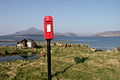
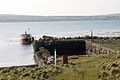
There is now a single occupied farm on the west side of the island, which has been in existence since at least the 1860s. The jetty, which first appears on the OS Second edition map (1904), lies at the south-western corner of the island; it is also possible to anchor off this point, while the beacon Sgeir Gobhlach appears on the First edition map (1882). A cluster of roofed and unroofed buildings is shown at the head of the jetty on the OS First edition map (1882), while a sheep pen is depicted on the current edition in this location. It issues its own postage stamps. [5]

Flora and Fauna

Pabay consists of heath, dry grassland, herb marsh, salt marsh, woodland remnants and 75 acres (30 hectares) of newly planted deciduous and coniferous trees, containing 17 different species. There are 32 different species of wild flowers, 49 different herbs, 40 different grasses, sedges, ferns and rushes. There are also numerous resident otters, seals, 32 breeding bird species and 72 non-breeding birds. There is also a large rabbit population and a smaller population of shrews.

Art

"Cricket on Pabay" is a painting by Elizabeth Edenborough. [9]

Stamps

Pabay has issued private carriage labels since at least the 1960s. [10]

Images

See also

Related Research Articles

<span class="mw-page-title-main">Hebrides</span> Archipelago off the west coast of Scotland

The Hebrides are an archipelago off the west coast of the Scottish mainland. The islands fall into two main groups, based on their proximity to the mainland: the Inner and Outer Hebrides.

<span class="mw-page-title-main">Benbecula</span> Island of the Outer Hebrides, Scotland

Benbecula is an island of the Outer Hebrides in the Atlantic Ocean off the west coast of Scotland. In the 2011 census, it had a resident population of 1,283 with a sizable percentage of Roman Catholics. It is in a zone administered by Comhairle nan Eilean Siar or the Western Isles Council. The island is about 12 kilometres from west to east and a similar distance from north to south. It lies between the islands of North Uist and South Uist and is connected to both by road causeways. Benbecula's main settlement and administrative centre is Balivanich.

<span class="mw-page-title-main">Inner Hebrides</span> Archipelago off the west coast of mainland Scotland

The Inner Hebrides is an archipelago off the west coast of mainland Scotland, to the south east of the Outer Hebrides. Together these two island chains form the Hebrides, which experience a mild oceanic climate. The Inner Hebrides comprise 35 inhabited islands as well as 44 uninhabited islands with an area greater than 30 hectares. Skye, Mull, and Islay are the three largest, and also have the highest populations. The main commercial activities are tourism, crofting, fishing and whisky distilling. In modern times the Inner Hebrides have formed part of two separate local government jurisdictions, one to the north and the other to the south. Together, the islands have an area of about 4,130 km2 (1,594 sq mi), and had a population of 18,948 in 2011. The population density is therefore about 4.6 inhabitants per square kilometre.

<span class="mw-page-title-main">Raasay</span> Island in Highland, Scotland

Raasay sometimes the Isle of Raasay is an island between the Isle of Skye and the mainland of Scotland. It is separated from Skye by the Sound of Raasay and from Applecross by the Inner Sound. It is famous for being the birthplace of Gaelic poet Sorley MacLean, an important figure in the Scottish Renaissance.

<span class="mw-page-title-main">Oronsay, Colonsay</span> Small tidal island south of Colonsay in the Scottish Inner Hebrides

Oronsay, also sometimes spelt and pronounced Oransay by the local community, is a small tidal island south of Colonsay in the Scottish Inner Hebrides with an area of 543 hectares.

<span class="mw-page-title-main">South Rona</span> Island in the Inner Hebrides, Scotland

Rona, sometimes called South Rona to distinguish it from North Rona, is an inhabited island in the Inner Hebrides. It lies between the Sound of Raasay and the Inner Sound just north of the neighbouring island of Raasay and east of the Trotternish peninsula of Skye. It has a total area of 930 hectares (3.6 sq mi) and a population of 3.

Scalpay is an inhabited island in the Inner Hebrides of Scotland which has a population of 4.

<span class="mw-page-title-main">Uist</span> Scottish islands

Uist is a group of six islands that are part of the Outer Hebridean Archipelago, which is part of the Outer Hebrides of Scotland.

<span class="mw-page-title-main">Wiay, Inner Hebrides</span> Uninhabited island off the Isle of Skye

Wiay, pronounced "waya" is an uninhabited island in Loch Bracadale, off the coast of the Isle of Skye

<span class="mw-page-title-main">Inner Sound, Scotland</span>

The Inner Sound is a strait separating the Inner Hebridean islands of Skye, Raasay and South Rona from the Applecross peninsula on the Scottish mainland. The Inner Sound is the location of BUTEC, a Royal Navy submarine sensor and emissions range.

<span class="mw-page-title-main">Clan Mackinnon</span> Highland Scottish clan

Clan MacKinnon is a Highland Scottish clan from the islands of Mull and Skye, in the Inner Hebrides.

<span class="mw-page-title-main">Isle of Ewe</span>

The Isle of Ewe is a small Scottish island on the west coast of Ross and Cromarty. The island is inhabited by a single family, the Grants, who have lived at the Main House in the south of the island since the mid-19th century.

<span class="mw-page-title-main">Longay</span>

Longay is a small uninhabited Scottish island in the Inner Sound just off the coast of the Isle of Skye, north of Pabay and east of Scalpay.

Fladda-chùain, or Fladaigh Chùain, is an island of the Inner Hebrides north of the Trotternish peninsula of Skye. It is the major island of the Fladda-chùain group between Skye and the Outer Hebrides.

<span class="mw-page-title-main">Nave Island</span>

Nave Island lies to the north of Islay in the Inner Hebrides near the mouth of Loch Gruinart. It is uninhabited.

<span class="mw-page-title-main">Isle of Skye</span> Island of the Inner Hebrides, Scotland

The Isle of Skye, or simply Skye, is the largest and northernmost of the major islands in the Inner Hebrides of Scotland. The island's peninsulas radiate from a mountainous hub dominated by the Cuillin, the rocky slopes of which provide some of the most dramatic mountain scenery in the country. Although Sgitheanach has been suggested to describe a winged shape, no definitive agreement exists as to the name's origins.

<span class="mw-page-title-main">Duirinish, Skye</span>

Duirinish is a peninsula and civil parish on the island of Skye in Scotland. It is situated in the north west between Loch Dunvegan and Loch Bracadale.

<i>Description of the Western Isles of Scotland</i> 16th-century Scottish manuscript

Description of the Western Isles of Scotland is the oldest known account of the Hebrides and the Islands of the Clyde, two chains of islands off the west coast of Scotland. The author was Donald Monro, a clergyman who used the title of "Dean of the Isles" and who lived through the Scottish Reformation. Monro wrote the original manuscript in 1549, although it was not published in any form until 1582 and was not widely available to the public in its original form until 1774. A more complete version, based on a late 17th-century manuscript written by Sir Robert Sibbald, was first published as late as 1961. Monro wrote in Scots and some of the descriptions are difficult for modern readers to render into English. Although Monro was criticised for publishing folklore and for omitting detail about the affairs of the churches in his diocese, Monro's Description is a valuable historical account and has reappeared in part or in whole in numerous publications, remaining one of the most widely quoted publications about the western islands of Scotland.

<span class="mw-page-title-main">Geology of the Isle of Skye</span>

The geology of the Isle of Skye in Scotland is highly varied and the island's landscape reflects changes in the underlying nature of the rocks. A wide range of rock types are exposed on the island, sedimentary, metamorphic and igneous, ranging in age from the Archaean through to the Quaternary.

Loch na Dal is a sea loch on the Sleat Peninsula on the Isle of Skye in the Inner Hebrides of Scotland. Kinloch Lodge, a hotel, is located on its northern shore and the A851 road runs along its southern shore. Although the meaning of the name is obscure in the current spelling, in the Blaeu Atlas of Scotland, 1654, the loch is listed as "Loch na Dallach". This could be "The Loch of the Delay" or "The Loch of the Meeting" or "The Loch of the Meadow". The later reading is possibly more likely, as a long river delta borders Abhainn Ceann-Locha as it enters the north end of Loch na Dal, and this piece of land is green and flat enough that it was at one time used as a football pitch.

References

  1. Area and population ranks: there are c.300 islands over 20ha in extent and 93 permanently inhabited islands were listed in the 2011 census.
  2. 2001 UK Census per List of islands of Scotland
  3. Ordnance Survey
  4. Haswell-Smith, Hamish (2004). The Scottish Islands. Edinburgh: Canongate. ISBN   978-1-84195-454-7.
  5. 1 2 "Overview for Pabay". Gazetteer for Scotland . Retrieved 15 December 2007.
  6. 1 2 "Isle of Pabay - History". Archived from the original on 18 September 2008. Retrieved 15 December 2007.
  7. "Vol 31 (2009): Mesolithic and later sites around the Inner Sound, Scotland the work of the Scotland's First Settlers project 1998-2004 | Scottish Archaeological Internet Reports". journals.socantscot.org. Retrieved 15 August 2021.
  8. Monro, Donald (High Dean of the Isles), Description of the Western Isles of Scotland (William Auld, Edinburgh, 1774), at page 26 (Google Books, accessed on 13 July 2010)
  9. "Cricket on Pabay" Archived 6 February 2016 at the Wayback Machine elizabethedenborough.co.uk Retrieved 31 July 2010.
  10. Retrieved 23 May 2020.

57°16′30″N5°51′35″W / 57.27500°N 5.85972°W / 57.27500; -5.85972