Scarba

Last updated

Scarba
Scottish Gaelic nameSgarba
Pronunciation [ˈs̪kaɾapə]
Old Norse nameSkarpoe
Meaning of nameOld Norse for "sharp, stony, hilly terrain"
Cruach Scarba - geograph.org.uk - 725175.jpg
Cruach Scarba
Location
Argyll and Bute UK relief location map.jpg
Red pog.svg
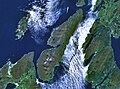
Scarba
Scarba shown within Argyll and Bute
OS grid reference NM690044
Coordinates 56°10′37″N5°43′12″W / 56.177°N 5.72°W / 56.177; -5.72
Physical geography
Island group Islay
Area1,474 ha (5+34 sq mi)
Area rank39 [1]
Highest elevationCruach Scarba 449 m (1,473 ft)
Administration
Sovereign state United Kingdom
Country Scotland
Council area Argyll and Bute
Demographics
PopulationNot permanently inhabited since the 1960s
Largest settlementKilmory Lodge
Lymphad3.svg
References [2] [3] [4]

Scarba (Scottish Gaelic : Sgarba) is an island, in Argyll and Bute, Scotland, just north of the much larger island of Jura. The island has not been permanently inhabited since the 1960s. [3] Until his death in 2013 it was owned by Richard Hill, 7th Baron Sandys; its owner now is Shane Cadzow who farms Luing cattle on the nearby island of Luing [5] and grazes some of the cattle on Scarba. [6] Kilmory Lodge is used seasonally as a shooting lodge, the island having a flourishing herd of red deer.

Contents

The island's name is from the Norse and may mean "sharp, stony, hilly terrain" [3] or "cormorant island". [7]

Description

Cruach Scarba
(Scottish Gaelic: 'Cruach Sgarba')
Highest point
Elevation 449 m (1,473 ft)
Prominence 449 m (1,473 ft)
Listing Marilyn
Naming
English translationHill of Scarba
Language of name Gaelic
Pronunciation ˈkʰɾuəx ˈs̪kaɾapə
Geography
Location Inner Hebrides, Scotland
OS grid NM690044
Topo map OS Landranger 55

Scarba is not served by any public ferries, but access from Craobh Haven or Crinan Harbour is possible by arrangement with local boatmen. The rough summit ridge can be accessed from the harbour at the north end, from where a vehicle track leads up past Kilmory Lodge to a height of about 200 metres. After that, there are no paths or well defined routes, and the terrain becomes rough and boggy. The island rises steeply to a peak (Cruach Scarba) of 449 metres (1,473 ft). A cylindrical triangulation point marks the highest of several summits, which are surrounded by several small lochs.

Geology

The western two-thirds of Scarba is formed from the Neoproterozoic aged coarse-grained quartzites of the Jura Quartzite Formation ascribed to the Islay Subgroup of the Dalradian Argyll Group. Separated from these rocks by a north–south aligned geological fault, the bedrock of the eastern third is the Neoproterozoic Scarba Conglomerate Formation, and the subordinate Jura Slate Member belonging to the Easdale Subgroup of the Argyll Group. North-south aligned dykes of amphibolite are found throughout the Jura Quartzite whilst lamprophyre dykes of Siluro-Devonian age and basalt and micro-gabbro dykes forming part of the Palaeogene age ‘Mull Dyke Swarm’ cut through both the Quartzite in the west and the conglomerate in the east. Raised marine deposits of sand and gravel occur on the northeast coast, a legacy of late Quaternary changes in relative sea-level. Peat deposits are common within the island's interior. [8] [9]

Corryvreckan

The whirlpool, with Scarba in the background The Corryvreckan Whirlpool - geograph-2404815-by-Walter-Baxter.jpg
The whirlpool, with Scarba in the background

Between Scarba and Jura lies the Gulf of Corryvreckan, known for its whirlpool. Writing in 1549, Dean Monro wrote of "Skarbay" that between it and "Duray":

Ther runnes ane streame, above the power of all sailing and rowing, with infinite dangers, callit Corybrekan. This stream is aught myle lang, quhilk may not be hantit bot be certain tyds. This Skarbay is four myles lange from the west to the eist, and an myle breadth, ane high rough yle, inhabit and manurit, with some woods in it. [10]

Scarba and a few nearby islets (Lunga and the Garvellachs) are collectively the Scarba, Lunga and the Garvellachs National Scenic Area, one of 40 such areas in Scotland, which are defined so as to identify areas of exceptional scenery and to ensure its protection by restricting certain forms of development. [11]

Footnotes

  1. Area and population ranks: there are c.300 islands over 20ha in extent and 93 permanently inhabited islands were listed in the 2011 census.
  2. National Records of Scotland (15 August 2013). "Appendix 2: Population and households on Scotland's Inhabited Islands" (PDF). Statistical Bulletin: 2011 Census: First Results on Population and Household Estimates for Scotland Release 1C (Part Two) (PDF) (Report). SG/2013/126. Retrieved 14 August 2020.
  3. 1 2 3 Haswell-Smith (2004) p. 60
  4. Ordnance Survey. OS Maps Online (Map). 1:25,000. Leisure.
  5. "Property Map | Who Owns Scotland".
  6. "The 'In Thing' is Luing". 26 August 2020.
  7. Mac an Tàilleir (2003) p. 104
  8. "Onshore Geoindex". British Geological Survey. British Geological Survey. Retrieved 5 February 2020.
  9. "Kilmartin, Scotland sheet 36, Bedrock and Superficial deposits". BGS large map images. British Geological Survey. Retrieved 5 February 2020.
  10. Monro (1594) "Skarbay" No. 16
  11. "National Scenic Areas". Scottish Natural Heritage. Retrieved 24 May 2018.

Related Research Articles

Great Cumbrae is the larger of the two islands known as The Cumbraes in the lower Firth of Clyde in western Scotland. The island is sometimes called Millport, after its main town.

<span class="mw-page-title-main">Inner Hebrides</span> Archipelago off the west coast of mainland Scotland

The Inner Hebrides is an archipelago off the west coast of mainland Scotland, to the south east of the Outer Hebrides. Together these two island chains form the Hebrides, which experience a mild oceanic climate. The Inner Hebrides comprise 35 inhabited islands as well as 44 uninhabited islands with an area greater than 30 hectares. Skye, Mull, and Islay are the three largest, and also have the highest populations. The main commercial activities are tourism, crofting, fishing and whisky distilling. In modern times the Inner Hebrides have formed part of two separate local government jurisdictions, one to the north and the other to the south. Together, the islands have an area of about 4,130 km2 (1,594 sq mi), and had a population of 18,948 in 2011. The population density is therefore about 4.6 inhabitants per square kilometre.

Scalpay is an inhabited island in the Inner Hebrides of Scotland which has a population of 4.

<span class="mw-page-title-main">Slate Islands</span>

The Slate Islands are an island group in the Inner Hebrides, lying immediately off the west coast of Scotland, north of Jura and southwest of Oban. The main islands are Seil, Easdale, Luing, Shuna, Torsa and Belnahua. Scarba and Kerrera, which lie nearby are not usually included.

The Garvellachs or Isles of the Sea form a small archipelago in the Inner Hebrides of Scotland. Part of the Argyll and Bute council area, they lie west of Lunga and northwest of Scarba and have been uninhabited since World War II.

<span class="mw-page-title-main">Seil</span>

Seil is one of the Slate Islands, located on the east side of the Firth of Lorn, 7 miles southwest of Oban, in Scotland. Seil has been linked to the mainland by bridge since the late 18th century.

<span class="mw-page-title-main">Luing</span>

Luing is one of the Slate Islands, Firth of Lorn, in the west of Argyll in Scotland, about 16 miles (26 km) south of Oban. The island has an area of 1,430 hectares and is bounded by several small skerries and islets. It has a population of around 200 people, mostly living in Cullipool, Toberonochy, and Blackmillbay.

<span class="mw-page-title-main">Belnahua</span>

Belnahua is one of the Slate Islands, in the Firth of Lorn in Scotland, known for its deserted slate quarries. The bedrock that underpins its human history is part of the Scarba Conglomerate Formation and its value has been on record since the 16th century. Likely uninhabited before commercial quarrying commenced, under the control of the Stevenson family during the 19th century the population expanded to over 150 before the island was abandoned again in 1914.

Torsa is one of the Slate Islands in Argyll and Bute, Scotland. Lying east of Luing and south of Seil, this tidal island was inhabited until the 1960s. There is now only one house there, which is used for holiday lets. The underlying bedrock is slate but unlike Torsa's immediate island neighbours this has never been worked commercially. The island's name is of Norse origin but the most prominent historical structure on the island is the ruined Caisteal nan Con on the northeast shore, once held by Clan Campbell. The abundant sea life in the waters surrounding the island are protected by the Loch Sunart to the Sound of Jura Marine Protected Area.

<span class="mw-page-title-main">Garbh Eileach</span> Island in Argyll and Bute, Scotland, UK

Garbh Eileach is an uninhabited island in the Inner Hebrides of the west coast of Scotland. It is the largest of the Garvellachs and lies in the Firth of Lorne between Mull and Argyll.

<span class="mw-page-title-main">Gulf of Corryvreckan</span> A narrow strait off the coast of Scotland

The Gulf of Corryvreckan, also called the Strait of Corryvreckan, is a narrow strait between the islands of Jura and Scarba, in Argyll and Bute, off the west coast of mainland Scotland.

<span class="mw-page-title-main">Firth of Lorn</span>

The Firth of Lorn or Lorne is the inlet of the sea between the south-east coast of the Isle of Mull and the mainland of Scotland. It includes a number of islands, and is noted for the variety of wildlife habitats that are found. In 2005, a large part of the Firth became a Special Area of Conservation.

Lunga is one of the Slate Islands in the Firth of Lorn in Argyll and Bute, Scotland. The "Grey Dog" tidal race, which runs in the sea channel to the south, reaches 8 knots (15 km/h) in full flood. The name "Lunga" is derived from the Old Norse for "isle of the longships', but almost all other place names are Gaelic in origin. The population was never substantial and today the main activity is an adventure centre on the northern headland of Rubha Fiola. The surrounding seas are fished for prawns and scallops and there is a salmon farm off the south eastern shores. The Special Area of Conservation of which the island is part hosts a growing number of outdoor leisure pursuits.

<span class="mw-page-title-main">Nave Island</span>

Nave Island lies to the north of Islay in the Inner Hebrides near the mouth of Loch Gruinart. It is uninhabited.

<span class="mw-page-title-main">Argyll Group</span>

The Argyll Group is a thick sequence of metamorphosed Neoproterozoic sedimentary rocks that outcrop across the Central Highlands of Scotland, east of the Great Glen, as well as appearing in the north of Ireland. It is a subdivision of the Dalradian Supergroup and is itself divided into four units; from oldest to youngest these are the Islay, Easdale, Crinan and Tayvallich subgroups.

<span class="mw-page-title-main">Colonsay</span> Island in the Inner Hebrides of Scotland

Colonsay is an island in the Inner Hebrides of Scotland, located north of Islay and south of Mull. The ancestral home of Clan Macfie and the Colonsay branch of Clan MacNeil, it is in the council area of Argyll and Bute and has an area of 4,074 hectares. Aligned on a south-west to north-east axis, it measures 8 miles in length and reaches 3 mi (5 km) at its widest point.

<span class="mw-page-title-main">Jura, Scotland</span> Island of the Inner Hebrides off Great Britain

Jura is an island in the Inner Hebrides of Scotland, adjacent to and northeast of Islay. With an area of 36,692 hectares (142 sq mi), and 196 inhabitants recorded in the 2011 census, Jura is more sparsely populated than Islay, and is one of the least densely populated islands of Scotland: in a list of the islands of Scotland ranked by size, Jura comes eighth, whereas by population it comes 31st. The island is mountainous, bare and largely infertile, covered by extensive areas of blanket bog.

<span class="mw-page-title-main">Scarba, Lunga and the Garvellachs National Scenic Area</span>

Scarba, Lunga and the Garvellachs is the name of one of the 40 national scenic areas of Scotland. The designated area covers the islands of Scarba, Lunga, and the Garvellachs, all of which lie in the Firth of Lorn, along with much of the surrounding seascape. The national scenic areas are defined so as to identify areas of exceptional scenery and to ensure its protection by restricting certain forms of development, and are considered to represent the type of scenic beauty "popularly associated with Scotland and for which it is renowned". The Scarba, Lunga and the Garvellachs NSA covers 6,542 ha in total, consisting of 2,139 ha of land with a further 4,402 ha being marine.

References

Commons-logo.svg Media related to Scarba at Wikimedia Commons

56°10′34″N5°43′24″W / 56.17607°N 5.72324°W / 56.17607; -5.72324