Loch Rannoch and Glen Lyon National Scenic Area

Last updated
Loch Rannoch and Glen Lyon National Scenic Area
Loch Rannoch.jpg
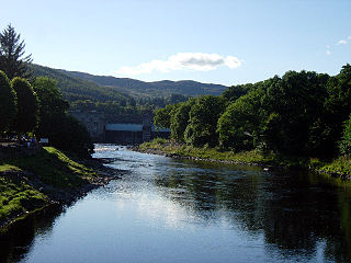
Looking across Loch Rannoch towards Schiehallion
Perth and Kinross UK relief location map.jpg
Red pog.svg
The location of Loch Rannoch, which lies in the northern part of the NSA, shown within Perth and Kinross.
Location Perth and Kinross and Stirling (council area), Scotland
Coordinates 56°40′59″N4°18′50″W / 56.68306°N 4.31389°W / 56.68306; -4.31389 Coordinates: 56°40′59″N4°18′50″W / 56.68306°N 4.31389°W / 56.68306; -4.31389
Area486 km2 (188 sq mi) [1]
Established1981
Governing body Scottish Natural Heritage

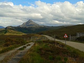
The Loch Rannoch and Glen Lyon National Scenic Area is a national scenic area (NSA) covering the area surrounding Loch Rannoch, Glen Lyon, and the Ben Lawers ranges of mountains in Scotland. [2] It is one of 40 such areas in Scotland, which are defined so as to identify areas of exceptional scenery and to ensure its protection from inappropriate development by restricting certain forms of development. [3] The Loch Rannoch and Glen Lyon NSA covers 48,625  ha, [1] [4] most of which lies in the council area of Perth and Kinross, with a small portion lying in Stirling. [5]

National scenic area (Scotland)

National scenic area (NSA) is a conservation designation used in Scotland, and administered by Scottish Natural Heritage (SNH). The designation's purpose is to identify areas of exceptional scenery and to protect them from inappropriate development. There are currently 40 national scenic areas (NSAs) in Scotland, covering 13% of the land area of Scotland. The areas protected by the designation are considered to represent the type of scenic beauty "popularly associated with Scotland and for which it is renowned". As such they tend to be mainly found in the remote, mountainous areas of Scotland, with an SNH review in 1997 noting a potential weakness of national scenic areas was that the original selection placed undue emphasis on the mountainous parts of Scotland. National scenic areas do however also cover seascapes, with approximately 26% of the total area protected by the designation being marine. The designation is primarily concerned with scenic qualities, although designated national scenic areas may well have other special qualities, for example related to culture, history, archaeology, geology or wildlife. Areas with such qualities may be protected by other designations that overlap with the NSA designation.

Loch Rannoch loch

Loch Rannoch is a freshwater loch in Perth and Kinross, Scotland. It is over 15 kilometres (9.3 mi) long in a west–east direction with an average width of about 1.2 kilometres (0.75 mi), and is deepest at its eastern end, reaching a depth of 130 metres (440 ft). The River Tummel begins at its eastern end, where the small village of Kinloch Rannoch can be found, whilst the wild expanse of Rannoch Moor extends to the west of the loch. The area surrounding Loch Rannoch, along with Rannoch Moor itself, was formerly part of the native Caledonian Forest that stretched across much of Northern Scotland. Native forest is now largely absent from much of area, due partly to logging, and partly to the climate becoming wetter, and Loch Rannoch is now largely surrounded by commercial forestry and open hillsides, although a small area remains at the Black Wood of Rannoch on the southern shore of the loch.

Glen Lyon is a glen in the Perth and Kinross region of Scotland. It is the longest enclosed glen in Scotland and runs for 34 miles from Loch Lyon in the west to the village of Fortingall in the east. This glen was also known as "An Crom Ghleann",. The land given over to the MacGregors was Scottish Gaelic: An Tòiseachd. It forms part of the Loch Rannoch and Glen Lyon National Scenic Area, one of 40 such areas in Scotland, which are defined so as to identify areas of exceptional scenery and to ensure its protection from inappropriate development by restricting certain forms of development. Sir Walter Scott described Glen Lyon as the longest, loneliest and loveliest glen in Scotland.

Contents

National scenic areas are primarily designated due to the scenic qualities of an area, however NSAs may well have other special qualities, for example related to culture, history, archaeology, geology or wildlife. [6] Areas with such qualities may be protected via other national and international designations that overlap with the NSA designation. Loch Rannoch and Glen Lyon includes a National nature reserve at Ben Lawers, and there are three Special Areas of Conservation and one Special Protection Area within the NSA. [7]

National nature reserve (Scotland)

The national nature reserves (NNRs) of Scotland are areas of land or water designated under the Wildlife and Countryside Act 1981 as containing habitats and species of national importance. National nature reserves can be owned by public, private, community or voluntary organisations but must be managed to conserve their important habitats and species, as well as providing opportunities for the public to enjoy and engage with nature. There are currently 43 NNRs in Scotland, which cover 154,250 hectares (1,542.5 km2), or less than 1.5% of the land area of Scotland. They range in size from Corrieshalloch Gorge at 7 ha to Mar Lodge Estate, which covers 29,324 ha.

Ben Lawers 1214m high mountain in Scotland

Ben Lawers is the highest mountain in the southern part of the Scottish Highlands. It lies to the north of Loch Tay, and is the highest point of a long ridge that includes seven Munros. It is the highest peak in Perthshire, and is the tenth highest Munro in Scotland. Ben Lawers was long thought to be over 4,000 feet (1,219.2 m) in height; accurate measurement in the 1870s showed it to be some 17 feet (5.2 m) short of this figure.

A Special Area of Conservation (SAC) is defined in the European Union's Habitats Directive (92/43/EEC), also known as the Directive on the Conservation of Natural Habitats and of Wild Fauna and Flora. They are to protect the 220 habitats and approximately 1000 species listed in annex I and II of the directive which are considered to be of European interest following criteria given in the directive. They must be chosen from the Sites of Community Importance by the State Members and designated SAC by an act assuring the conservation measures of the natural habitat.

Creation of the national scenic area

Following the Second World War, a committee, chaired by Sir Douglas Ramsay, was established to consider preservation of the landscape in Scotland. The report, published in 1945 proposed that five areas (Loch Lomond and the Trossachs, the Cairngorms, Glen Coe-Ben Nevis-Black Mount, Wester Ross and Glen Strathfarrar-Glen Affric-Glen Cannich) should receive a level of protection. [8] The government therefore designated these areas as "national park direction areas", giving powers for planning decisions taken by local authorities to be reviewed by central government. Following a further review of landscape protection in 1978, additional areas, including the hills and glens to the east of Rannoch Moor, were identified as worthy of protection due to their landscape qualities. Accordingly, in 1981 the direction areas were replaced by the national scenic area designation, which were based on the 1978 recommendations and thus included the area entitled Loch Rannoch and Glen Lyon. [9] The defined area remains as originally mapped in 1978, but was redesignated under new legislation in 2010. [10]

Loch Lomond and The Trossachs National Park national park

Loch Lomond and The Trossachs National Park is a national park in Scotland centred on Loch Lomond and the hills and glens of the Trossachs, along with several other ranges of hills. It was the first of the two national parks established by the Scottish Parliament in 2002, the second being the Cairngorms National Park. The park consists of many mountains and lochs, and the principal attractions are scenery, walking, and wildlife.

Cairngorms mountain range in the eastern Highlands of Scotland

The Cairngorms are a mountain range in the eastern Highlands of Scotland closely associated with the mountain of the Cairn Gorm. The Cairngorms became part of Scotland's second national park on 1 September 2003. Although the Cairngorms give their name to, and are at the heart of, the Cairngorms National Park, they only form one part of the national park, alongside other hill ranges such as the Angus Glens and the Monadhliath, and lower areas like Strathspey.

Ben Nevis and Glen Coe National Scenic Area mountain in Argyll and Bute, Scotland, UK

Ben Nevis and Glen Coe is a national scenic area (NSA) covering part of the Highlands of Scotland surrounding Ben Nevis and Glen Coe, in which certain forms of development are restricted. It is one of 40 such areas in Scotland, which are defined so as to identify areas of exceptional scenery and to ensure its protection from inappropriate development. The Ben Nevis and Glen Coe NSA covers 90,334 ha, lying within the Highland, Argyll and Bute and Perth and Kinross council areas. A further 1,944 ha of the NSA are marine, covering the sea loch of Loch Leven.

Although the national scenic area designation provides a degree of additional protection via the planning process, there are no bodies equivalent to a national park authority, [11] and whilst local authorities (in this case Perth and Kinross Council and Stirling Council) can produce a management strategy for each one, only the three national scenic areas within Dumfries and Galloway have current management strategies. [12]

A national park authority is a special term used in the United Kingdom for legal bodies charged with maintaining a national park of which as of December 2016 there are ten in England, three in Wales and two in Scotland. The powers and duties of all such authorities are similar, but their work varies depending on where they are situated.

Subdivisions of Scotland present or former administrative subdivision of Scotland

For local government purposes, Scotland is divided into 32 areas designated as "council areas", which are all governed by single-tier authorities designated as "councils". They have the option under the Local Government (Scotland) Act 1997 of being known as a "comhairle" when opting for a Gaelic name; only Comhairle nan Eilean Siar has chosen this option, whereas the Highland Council has adopted its Gaelic form alongside its English equivalent informally.

Perth and Kinross Council is the local government council for the Perth and Kinross council area of Scotland. It employs around 6,000 employees.

Geography

Main articles: Ben Lawers, Loch Rannoch and Glen Lyon

The designated area covers much of the historical province of Breadalbane, and covers landscapes ranging from flat, fertile farmland up to exposed mountain summits. [5] Ben Lawers, at 1214 m, is the highest point in the highest and most extensive mountain massif in the southern part of the Scottish Highlands. [13] Schiehallion, an isolated peak lying in the east of the NSA, is one of the most prominent mountains in Scotland.

Breadalbane, Scotland Scottish region

Breadalbane —from Scottish Gaelic Bràghad Albainn, "the upper part of Alba"—is a region of the southern/central Scottish Highlands, traditionally comprising the watershed of Loch Tay. The Breadalbane Hydro-Electric Scheme lies within the region.

Schiehallion Scottish mountain

Schiehallion is a prominent mountain in Perth and Kinross, Scotland. Schiehallion has a rich botanical life, interesting archaeology, and a unique place in scientific history for an 18th-century experiment in "weighing the world". The mountain's popularity amongst walkers led to erosion on its footpath and extensive repairs were undertaken in 2001.

Topographic prominence characterizes the height of a mountain or hills summit by the vertical distance between it and the lowest contour line encircling it but containing no higher summit within it; it is a measure of the independence of a summit

In topography, prominence measures the height of a mountain or hill's summit relative to the lowest contour line encircling it but containing no higher summit within it. It is a measure of the independence of a summit. A peak's key col is a unique point on this contour line and the parent peak is some higher mountain, selected according to various criteria.

The area is drained by two tributaries of the River Tay: the River Tummel (which drains Loch Rannoch) and the River Lyon, which flows through Glen Lyon. [2] Most human settlement and activity has been concentrated along these two rivers; many of the smaller side glens also contain visible signs of previous occupations, for example in the presence of old shielings. [5] The area contains fragments of the ancient Caledonian pinewood, along with areas of native birchwood. [5]

Tributary stream or river that flows into a main stem river or lake

A tributary or affluent is a stream or river that flows into a larger stream or main stem river or a lake. A tributary does not flow directly into a sea or ocean. Tributaries and the main stem river drain the surrounding drainage basin of its surface water and groundwater, leading the water out into an ocean.

River Tay river in Scotland

The River Tay is the longest river in Scotland and the seventh-longest in the United Kingdom. The Tay originates in western Scotland on the slopes of Ben Lui, then flows easterly across the Highlands, through Loch Dochart, Loch Iubhair and Loch Tay, then continues east through Strathtay, in the centre of Scotland, then southeasterly through Perth, where it becomes tidal, to its mouth at the Firth of Tay, south of Dundee. It is the largest river in the UK by measured discharge. Its catchment is approximately 2,000 square miles (5,200 km2), the Tweed's is 1,500 square miles (3,900 km2) and the Spey's is 1,097 square miles (2,840 km2).

River Tummel river in the United Kingdom

The River Tummel is a river in Perth and Kinross, Scotland. Water from the Tummel is used in the Tummel hydro-electric power scheme, operated by SSE.

Other conservation designations

There are a number of other protected areas that overlap to some extent with the national scenic area. [7]

Related Research Articles

National parks of Scotland

The national parks of Scotland are managed areas of outstanding landscape where some forms of development are restricted to preserve the landscape and natural environment. At present, Scotland has two national parks: Loch Lomond and The Trossachs National Park, created in 2002, and the Cairngorms National Park, created in 2003.

Scottish Natural Heritage is the public body responsible for Scotland's natural heritage, especially its natural, genetic and scenic diversity. It advises the Scottish Government and acts as a government agent in the delivery of conservation designations, i.e. national nature reserves, local nature reserves, long distance routes, national parks, Sites of Special Scientific Interest (SSSIs), Special Areas of Conservation, Special Protection Areas and the national scenic area.

River Dee, Aberdeenshire river in Aberdeenshire, Scotland

The River Dee is a river in Aberdeenshire, Scotland. It rises in the Cairngorms and flows through southern Aberdeenshire to reach the North Sea at Aberdeen. The area it passes through is known as Deeside, or Royal Deeside in the region between Braemar and Banchory because Queen Victoria came to love the place and built Balmoral Castle there.

River Nith river in Scotland

The River Nith is a river in south-west Scotland. The Nith rises in the Carsphairn hills of East Ayrshire, more precisely between Prickeny Hill and Enoch Hill, 4.4 miles (7.1 km) east of Dalmellington. For the majority of its course it flows in a southerly direction through Dumfries and Galloway and then into the Solway Firth at Airds point.

Loch Tummel lake in the United Kingdom

Loch Tummel is a long, narrow loch, 7 km (4.3 mi) north west of Pitlochry in the council area of Perth and Kinross, Scotland. It is fed and drained by the River Tummel, which flows into the River Tay about 13 km (8.1 mi) south-east of the Clunie Dam at the loch's eastern end.

River Earn river in Scotland

The River Earn in Scotland leaves Loch Earn at St Fillans and runs east through Strathearn, then east and south, joining the River Tay near Abernethy. The Earn is about 74 kilometres (46 mi) long. It passes by Comrie, Crieff and Bridge of Earn. The river is fast flowing, with many shoals, whilst the surrounding land is generally flat and is occasionally subject to flooding.

South Lewis, Harris and North Uist National Scenic Area

South Lewis, Harris and North Uist is a large national scenic area (NSA) in the Western Isles of Scotland. It is one of 40 such areas in Scotland, which are defined so as to identify areas of exceptional scenery and to ensure its protection from inappropriate development. The designated area covers 202,388 ha in total, of which 112,301 ha is on land, with a further 90,087 ha being marine, making it the largest of the NSAs in both total and marine area. The designated area includes the mountainous south west of Lewis, all of Harris, the Sound of Harris and the northern part of North Uist.

Hoy and West Mainland National Scenic Area

Hoy and West Mainland is a national scenic area (NSA) covering parts of the islands of Hoy and Mainland in the Orkney Islands of Scotland, as well as parts of the surrounding sea. It is one of 40 such areas in Scotland, which are defined so as to identify areas of exceptional scenery and to ensure its protection by restricting certain forms of development. The Hoy and West Mainland NSA covers 24,407 ha in total, consisting of 16,479 ha of land with a further 7928 ha being marine.

Morar, Moidart and Ardnamurchan National Scenic Area

Morar, Moidart and Ardnamurchan is a national scenic area (NSA) covering the coastal scenery of three peninsulas in the western Highlands of Scotland: Ardnamurchan, Moidart and Morar. It is one of 40 such areas in Scotland, which are defined so as to identify areas of exceptional scenery and to ensure its protection from inappropriate development by restricting certain forms of development. The Morar, Moidart and Ardnamurchan NSA covers 36,956 ha in total, consisting of 17,220 ha of land with a further 19,736 ha being marine.

North West Sutherland National Scenic Area

North West Sutherland is a national scenic area (NSA) covering the mountains and coastal scenery of the northwestern part of the county of Sutherland in the highlands of Scotland. The designated area covers the mountains of Foinaven, Arkle and Ben Stack as well as the coastal scenery surrounding Loch Laxford and Handa Island. It is one of 40 such areas in Scotland, which are defined so as to identify areas of exceptional scenery and to ensure its protection by restricting certain forms of development. The North West Sutherland NSA covers 26,565 ha in total, consisting of 23,415 ha of land with a further 3,151 ha being marine.

Scarba, Lunga and the Garvellachs National Scenic Area

Scarba, Lunga and the Garvellachs is the name of one of the 40 national scenic areas of Scotland. The designated area covers the islands of Scarba, Lunga and the Garvellachs, all of which lie in the Firth of Lorn, along with much of the surrounding seascape. The national scenic areas are defined so as to identify areas of exceptional scenery and to ensure its protection by restricting certain forms of development, and are considered to represent the type of scenic beauty "popularly associated with Scotland and for which it is renowned". The Scarba, Lunga and the Garvellachs NSA covers 6,542 ha in total, consisting of 2,139 ha of land with a further 4,402 ha being marine.

Upper Tweeddale National Scenic Area

The Upper Tweeddale National Scenic Area lies in the Borders region of Scotland. It is one of 40 national scenic areas (NSA) in Scotland, which are defined so as to identify areas of exceptional scenery and to ensure their protection from inappropriate development. The designated area covers 12,770 ha of countryside surrounding the upper reaches of the River Tweed between Broughton and Peebles.

References

  1. 1 2 "National Scenic Areas - Maps". SNH. 2010-12-20. Retrieved 2018-01-24.
  2. 1 2 "Map: Loch Rannoch and Glen Lyon National Scenic Area" (PDF). Scottish Natural Heritage. December 2010. Retrieved 2018-03-19.
  3. "National Scenic Areas". Scottish Natural Heritage. Retrieved 2018-01-17.
  4. "Loch Rannoch and Glen Lyon". Protected Planet. Retrieved May 25, 2018.
  5. 1 2 3 4 "The special qualities of the National Scenic Areas" (PDF). Scottish Natural Heritage. 2010. pp. 105–113. Retrieved 2018-01-24.
  6. "The special qualities of the National Scenic Areas" (PDF). Scottish Natural Heritage. 2010. p. 2. Retrieved 2018-05-15.
  7. "History Leading to the Cairngorms National Park". Cairngorms National Park Authority. Retrieved 2018-01-15.
  8. "National Scenic Areas Review" (PDF). SNH. 1997. Retrieved 2018-02-05.
  9. "National Scenic Areas: background, guidance and policy". SNH. Retrieved 2018-01-31.
  10. "Development management and National Scenic Areas". SNH. 2017. Retrieved 2018-01-23.
  11. "National Scenic Areas (NSAs)". Dumfries and Galloway council. 2017-12-08. Retrieved 2018-01-24.
  12. D. Bennet & R. Anderson. The Munros: Scottish Mountaineering Club Hillwalkers Guide, pp. 30-32. Published 2016.
  13. "Site Details for Ben Lawers NNR". Scottish Natural Heritage. 2018-04-05. Retrieved 2018-04-24.
  14. "Ben Lawers National Nature Reserve". National Trust for Scotland. Retrieved 2018-04-24.
  15. NTS Guide (2018).
  16. "Site Details for Ben Lawers SAC". Scottish Natural Heritage. 2018-04-05. Retrieved 2018-04-24.
  17. "Site Details for River Tay SAC". Scottish Natural Heritage. 2018-04-05. Retrieved 2018-04-24.
  18. "Site Details for Black Wood of Rannoch SAC". Scottish Natural Heritage. 2018-04-05. Retrieved 2018-04-24.
  19. Ordnance Survey Landranger 1:50000 Map. Sheet 51. Loch Tay and Glen Rannoch
  20. "Site Details for Rannoch Lochs SPA". Scottish Natural Heritage. 2018-04-05. Retrieved 2018-04-24.