National nature reserve (Scotland)

Last updated

St Abb's Head NNR in Berwickshire, seen from the south near the village of St Abbs. St Abbs Head from St Abbs.jpg
St Abb's Head NNR in Berwickshire, seen from the south near the village of St Abbs.

The national nature reserves (NNRs) of Scotland are areas of land or water designated under the Wildlife and Countryside Act 1981 as containing habitats and species of national importance. National nature reserves can be owned by public, private, community or voluntary organisations but must be managed to conserve their important habitats and species, as well as providing opportunities for the public to enjoy and engage with nature. There are currently 43 NNRs in Scotland, which cover 154,250 hectares (1,542.5 km2), [1] or less than 1.5% of the land area of Scotland. [2] They range in size from Corrieshalloch Gorge at 7 ha to Mar Lodge Estate, which covers 29,324 ha. [1]

Contents

National nature reserve status is an accolade awarded to the best nature reserves in Scotland, and the selected sites provide examples of nationally or internationally important species and habitats. NNRs are intended to showcase Scotland's nature, and as well as being well managed for wildlife they must be managed to provide opportunities for the public to visit and enjoy them. NNRs therefore generally have facilities such as visitor centres and trails to allow visitors to explore and understand the habitats or wildlife they contain. [1] 19 of the reserves NNRs have IUCN Category II (national park) status, including, Glen Affric, Rùm, Abernethy Forest and the Great Trossachs Forest. There are no reserves with this status in England, Wales or Northern Ireland. This is mainly due to Scotland's natural habitats being more intact than in the rest of the UK.[ citation needed ]

Most NNRs in Scotland are also designated as Sites of Special Scientific Interest. Many also form part of the Natura 2000 network, which covers Special Protection Areas and Special Areas of Conservation. Additionally, some of the NNRs are designated as Ramsar sites. [3]

History

National nature reserves were first created under the National Parks and Access to the Countryside Act 1949. [4] In 1996 the public body responsible for Scotland's natural heritage, Scottish Natural Heritage (SNH – since renamed NatureScot), undertook a review of NNR policy that took account of the availability of other designations conferring legal protection, such as site of special scientific interest, special protection area and special area of conservation. It was determined that NNR should possess four attributes: [4]

Additionally, it was determined that NNRs should be managed for at least one of three purposes: [4]

Between 2000 and 2003 the existing NNRs were reviewed against these criteria. Prior to 2004 there were 73 national nature reserves in Scotland, however a number have since been de-designated. [4] New NNRs have also been designated, such as the National Trust for Scotland's Glen Coe and Mar Lodge properties, which were both designated NNRs in 2017. [5]

Since 2012 governance of the NNR designation in Scotland has been through a partnership group, comprising representatives of existing reserve management organisations and community land groups, chaired by NatureScot. NatureScot remains responsible for the statutory declaration of national nature reserves. [2]

Maintenance and management

The logo used for Scotland's national nature reserves. Scotland NNR logo.png
The logo used for Scotland's national nature reserves.

NatureScot is responsible for designating NNRs in Scotland and for overseeing the maintenance and management of each reserve. [6] The majority of NNRs are directly managed by NatureScot; however, some are managed by, or in co-operation with other bodies. The NNR partnership consists of nine bodies: [2]

Details on the management of each reserve are shown in the table below.

List of national nature reserves in Scotland

NameRegion (as defined by NatureScot)Management
Abernethy Forest Highlands and SkyeNatureScot / RSPB [7]
Ariundle Oakwood Highlands and SkyeNatureScot / FLS [8]
Beinn Eighe and Loch Maree Islands Highlands and SkyeNatureScot [9]
Ben Lawers Tayside and FifeNTS [10]
Ben Wyvis Highlands and SkyeNatureScot / FLS [11]
Blawhorn Moss Central BeltNatureScot [12]
Caerlaverock South of ScotlandNatureScot [13]
Cairnsmore of Fleet South of ScotlandNatureScot [14]
Clyde Valley Woodlands Central BeltNatureScot / SWT / South Lanarkshire Council [15]
Corrie Fee Tayside and FifeNatureScot [16]
Corrieshalloch Gorge Highlands and SkyeNTS [17]
Craigellachie Highlands and SkyeNatureScot [18]
Creag Meagaidh Highlands and SkyeNatureScot [19]
Flanders Moss West HighlandsNatureScot [20]
Forsinard Flows Highlands and SkyeRSPB [21]
Forvie Grampian HighlandsNatureScot [22]
Glasdrum Wood West HighlandsNatureScot [23]
Glen Affric Highlands and SkyeFLS [24]
Glen Coe West HighlandsNTS [25]
Glen Nant West HighlandsFLS [26]
Glen Roy Highlands and SkyeNatureScot [27]
Glen Tanar Grampian HighlandsGlen Tanar Estate [28]
Glen More Highlands and SkyeFLS [29]
The Great Trossachs Forest West HighlandsRSPB / FLS / Woodland Trust [30]
Hermaness Northern IslesNatureScot [31]
Insh Marshes Highlands and SkyeRSPB [32]
Invereshie and Inshriach Highlands and SkyeNatureScot / FLS [33]
Isle of May Tayside and FifeNatureScot [34]
Knockan Crag Highlands and SkyeNatureScot [35]
Loch Fleet Highlands and SkyeNatureScot / SWT [36]
Loch Leven Tayside and FifeNatureScot / RSPB [37]
Loch Lomond West HighlandsNatureScot / Loch Lomond & The Trossachs National Park [38]
Mar Lodge Estate Grampian HighlandsNTS [39]
Moine Mhòr West HighlandsNatureScot [40]
Muir of Dinnet Grampian HighlandsNatureScot [41]
Noss Northern IslesNatureScot [42]
Rum Highlands and SkyeNatureScot [43]
St Abb's Head South of ScotlandNTS [44]
St Cyrus Grampian HighlandsNatureScot [45]
St Kilda Western IslesNTS [46]
Staffa West HighlandsNTS [47]
Taynish West HighlandsNatureScot [48]
Tentsmuir Tayside and FifeNatureScot [49]

Former NNRs, de-declared since 2004

See also

Related Research Articles

<span class="mw-page-title-main">NatureScot</span> Scottish government agency for natural heritage conservation

NatureScot is the operating name for the body formally called Scottish Natural Heritage. It is an executive non-departmental public body of the Scottish Government responsible for the country's natural heritage, especially its natural, genetic and scenic diversity. It advises the Scottish Government on nature conservation, and acts as a government agent in the delivery of conservation designations, i.e. national nature reserves, local nature reserves, national parks, Sites of Special Scientific Interest (SSSIs), Special Areas of Conservation, Special Protection Areas and the national scenic areas. It receives annual funding from the Government in the form of Grant in Aid to deliver Government priorities for the natural heritage.

<span class="mw-page-title-main">Caerlaverock National Nature Reserve</span>

Caerlaverock is a national nature reserve (NNR) covering parts of the mudflats and shoreline of the Solway Firth about 10 km south of Dumfries, in Dumfries and Galloway, Scotland. It lies between the River Nith and the Lochar Water, and consists of a variety of wetland habitats including bare mud and sand, merse and marshes, and is fringed by neutral grassland on the landward side. A nature reserve was designated in 1957 at the instigation of the Duke of Norfolk. The NNR covers an area of 82 square kilometres (32 sq mi) and is an internationally important wintering site for waterfowl and wading birds.

<span class="mw-page-title-main">Ben Wyvis</span> Mountain in Highland, Scotland, UK

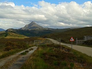
Ben Wyvis is a mountain in Easter Ross, in the northern Highlands of Scotland. It lies north-west of Dingwall, in the council area of Highland, and the county of Ross and Cromarty. Ben Wyvis is a large winding and undulating ridge running roughly north–south for about 5 km, the highest point of which is Glas Leathad Mòr at 1,046 metres (3,432 ft). Geologically, the ridge is composed of Moine pelitic gneiss. The mountain is prominent in views of the area, presenting a whale-back shape above the farmland of Strathconon.

<span class="mw-page-title-main">Creag Meagaidh</span> Mountain in the Scottish Highlands

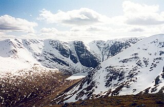
Creag Meagaidh is a mountain on the northern side of Glen Spean in the Highlands of Scotland. It is a complex mountain, made up of a flat summit plateau, with five ridges spreading out from it, overlooking five deep corries; it is most famed for the cliffs surrounding the corrie of Coire Ardair on the north-eastern face. These crags are a renowned venue for ice climbing. Creag Meagaidh rises to 1,130 metres (3,710 ft).

<span class="mw-page-title-main">Glen Affric</span> Valley in northern Scotland

Glen Affric is a glen south-west of the village of Cannich in the Highland region of Scotland, some 15 miles west of Loch Ness. The River Affric runs along its length, passing through Loch Affric and Loch Beinn a' Mheadhoin. A minor public road reaches as far as the end of Loch Beinn a' Mheadhoin, but beyond that point only rough tracks and footpaths continue along the glen.

<span class="mw-page-title-main">Glenmore Forest Park</span> Park in Highland, Scotland, UK

Glenmore Forest Park is a remnant of the Caledonian Forest near Aviemore in the Badenoch and Strathspey district of Highland, Scotland. Owned and managed by Forestry and Land Scotland, it lies within the Cairngorms National Park, and is one of six forest parks in the country. The forest park, which was established in 1948, covers 35.7 km2, of which 21.1 km2 is designated as a national nature reserve (NNR). Glenmore surrounds Loch Morlich, and is below the rise of the Cairngorms to the south; to the north the park extends to the summit of Meall a' Bhuachaille. The forest forms part of an expanse of Caledonian Forest that stretches from Glen Feshie to Abernethy, and which as a whole forms the largest single area of this habitat remaining in Scotland. It is home to much wildlife including Scottish crossbills, crested tits, capercaillie, narrow-headed ants, red squirrels and red deer.

<span class="mw-page-title-main">Abernethy Forest</span> Forest in Highland, Scotland, UK

Abernethy Forest is a remnant of the Caledonian Forest in Strathspey, in the Highland council area of Scotland. It lies within the Cairngorms National Park, close to the villages of Nethy Bridge, Boat of Garten, and Aviemore. The forest is an RSPB reserve, close to Loch Garten Osprey Centre, which is also owned by the RSPB. It is popular with walkers, as there are various trails throughout the reserve. The forest forms part of the wider Abernethy National Nature Reserve.

<span class="mw-page-title-main">Corrie Fee</span> Corrie and nature reserve in Angus, Scotland

Corrie Fee is a glacier-carved corrie situated at the head of Glen Clova in the Angus Glens of Scotland. It forms part of Corrie Fee National Nature Reserve (NNR), which is managed by NatureScot and lies within the Cairngorms National Park. The adjoining Corrie Sharroch and the slopes of Craig Rennet are also included in the NNR.

<span class="mw-page-title-main">South Lewis, Harris and North Uist National Scenic Area</span>

South Lewis, Harris and North Uist is a large national scenic area (NSA) in the Western Isles of Scotland. It is one of 40 such areas in Scotland, which are defined so as to identify areas of exceptional scenery and to ensure its protection from inappropriate development. The designated area covers 202,388 ha in total, of which 112,301 ha is on land, with a further 90,087 ha being marine, making it the largest of the NSAs in both total and marine area. The designated area includes the mountainous south west of Lewis, all of Harris, the Sound of Harris and the northern part of North Uist.

<span class="mw-page-title-main">Tentsmuir National Nature Reserve</span>

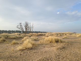
Tentsmuir National Nature Reserve (NNR) is located southeast of Tayport in Fife, Scotland. The reserve is made up of three parts, encompassing Morton Lochs, Tentsmuir Point and Tayport Heath, and is managed by NatureScot. The different sections of Tentsmuir NNR were originally designated as separate national nature reserves at different times: the Morton Lochs section was designated in 1952; Tentsmuir Point in 1954; and Tayport Heath in 1988. While these discrete sections are distant from one another, they form part of the extensive dune system at Tentsmuir, and in 2003 SNH combined the three sites to form Tentsmuir National Nature Reserve. The adjoining Tentsmuir Forest is managed by Forestry and Land Scotland and covers most of the land between the three portions of the NNR.

<span class="mw-page-title-main">Loch Druidibeg</span> Loch in Outer Hebrides, Scotland

Loch Druidibeag is a freshwater loch situated on the island of South Uist, in the Outer Hebrides of Scotland. The loch is near the northern end of the island, to the north-east of Howmore and to the east of the A865 road and south of the B890.

<span class="mw-page-title-main">Blawhorn Moss</span>

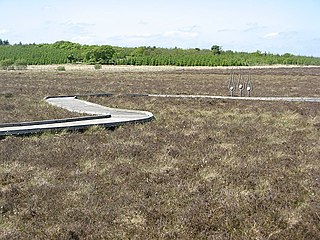
Blawhorn Moss is a raised bog located to the northwest of the village of Blackridge, about 6 kilometres (3.7 mi) west of Armadale in the council area of West Lothian in central Scotland. It is the largest and least disturbed raised bog in the Lothians, and has been a National Nature Reserve since 1980. It is owned and managed by NatureScot, the public body responsible for Scotland's natural heritage.

<span class="mw-page-title-main">Glasdrum Wood</span>

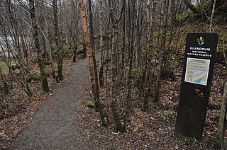
Glasdrum Wood is national nature reserve (NNR) at the head of Loch Creran in Argyll and Bute on the west coast of Scotland. Managed by NatureScot, the wood is renowned for its diverse flora and fauna, including sessile oak and ash trees, mosses, liverworts and rare invertebrates, like the chequered skipper butterfly. The NNR covers an area of around 169 hectares, encompassing woodland and hillside on the lower slopes of Beinn Churlain. A carpark and 1 km-long waymarked trail are provided for visitors. Since 2004 the reserve has received approximately 2800 visitors each year.

<span class="mw-page-title-main">Loch Lomond National Nature Reserve</span> A nature reserve in Scotland

Loch Lomond National Nature Reserve (NNR) encompasses 430 hectares of land at the southeastern part of Loch Lomond in the council areas of Stirling and West Dunbartonshire, in Scotland. It covers the islands of Inchcailloch, Clairinsh, Torrinch, Creinch and Aber Isle, alongside areas of woodland and wetlands to either side of the mouth of the Endrick Water. NatureScot owns two parts of the reserve - the island of Inchcailloch and part of Gartfairn Wood - and the rest is privately owned. The reserve is managed by a partnership consisting of NatureScot, the RSPB Scotland and the Loch Lomond and The Trossachs National Park, along with the owners and tenants of the land under agreements. Within this framework NatureScot directly manage the islands of Clairinsh, Inchcailloch, Torrinch and Creinch, and land to the north of the Endrick Water. The RSPB manages the area to the south of the Endrick Water, and the national park manages visitor facilities on Inchcailloch.

<span class="mw-page-title-main">Protected areas of Scotland</span> Designated area for protection in Scotland

Many parts of Scotland are protected in accordance with a number of national and international designations because of their environmental, historical or cultural value. Protected areas can be divided according to the type of resource which each seeks to protect. NatureScot has various roles in the delivery of many environmental designations in Scotland, i.e. those aimed at protecting flora and fauna, scenic qualities and geological features. Historic Environment Scotland is responsible for designations that protect sites of historic and cultural importance. Some international designations, such as World Heritage Sites, can cover both categories of site.

<span class="mw-page-title-main">Ben Nevis and Glen Coe National Scenic Area</span>

Ben Nevis and Glen Coe is a national scenic area (NSA) covering part of the Highlands of Scotland surrounding Ben Nevis and Glen Coe, in which certain forms of development are restricted. It is one of 40 such areas in Scotland, which are defined so as to identify areas of exceptional scenery and to ensure its protection from inappropriate development. The Ben Nevis and Glen Coe NSA covers 903 km2 (349 sq mi) of land, lying within the Highland, Argyll and Bute and Perth and Kinross council areas. A further 19 km2 (7.3 sq mi) of the NSA are marine, covering the sea loch of Loch Leven.

<span class="mw-page-title-main">Loch Rannoch and Glen Lyon National Scenic Area</span>

The Loch Rannoch and Glen Lyon National Scenic Area is a national scenic area (NSA) covering the area surrounding Loch Rannoch, Glen Lyon, and the Ben Lawers ranges of mountains in Scotland. It is one of 40 such areas in Scotland, which are defined so as to identify areas of exceptional scenery and to ensure its protection from inappropriate development by restricting certain forms of development. The Loch Rannoch and Glen Lyon NSA covers 48,625 ha, most of which lies in the council area of Perth and Kinross, with a small portion lying in Stirling.

<span class="mw-page-title-main">North West Sutherland National Scenic Area</span>

North West Sutherland is a national scenic area (NSA) covering the mountains and coastal scenery of the northwestern part of the county of Sutherland in the highlands of Scotland. The designated area covers the mountains of Foinaven, Arkle and Ben Stack as well as the coastal scenery surrounding Loch Laxford and Handa Island. It is one of 40 such areas in Scotland, which are defined so as to identify areas of exceptional scenery and to ensure its protection by restricting certain forms of development. The North West Sutherland NSA covers 26,565 ha in total, consisting of 23,415 ha of land with a further 3,151 ha being marine.

<span class="mw-page-title-main">Invereshie and Inshriach National Nature Reserve</span>

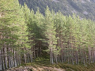
Invereshie and Inshriach is a national nature reserve on the western flank of the Cairngorms in the Highland council area of Scotland. The reserve covers habitats at a range of different altitudes, ranging from Caledonian Forest beside the River Feshie in the west, via bog and open moorland, to an arctic-alpine environment on the Cairngorm plateau. The Munro summit of Sgòr Gaoith (1118 m) lies on the eastern boundary of the reserve. The forested areas of the reserve form part of an expanse of Caledonian pinewood that stretches from Glen Feshie to Abernethy, and which as a whole forms the largest single area of this habitat remaining in Scotland. The reserve is owned and managed jointly by NatureScot and Forestry and Land Scotland (FLS): NatureScot own the Invereshie portion of the reserve and FLS the Inshriach area.

<span class="mw-page-title-main">Moine Mhòr</span> Area of raised bog in Argyll and Bute, Scotland

Moine Mhòr encompasses a large area of raised bog in the Kilmartin Glen area of Argyll and Bute, Scotland. As well as raised bog there are areas of saltmarsh, brackish grassland, alder carr, fen and woodland, and the variety of habitats at Moine Mhòr provide important habitats for a variety of animal and plant species. The area was declared a national nature reserve (NNR) in 1987, and is now owned and managed by NatureScot. According to NatureScot lowland raised bogs like Moine Mhòr are some of the rarest and most threatened natural wildlife habitats in Europe, due to removal of peat, afforestation and reclamation of farmland.

References

  1. 1 2 3 "About NNRs". Scottish Natural Heritage. Retrieved 10 April 2018.
  2. 1 2 3 "National Nature Reserves". Scottish Natural Heritage. Retrieved 30 January 2018.
  3. "National Nature Reserves and other protected areas". Scotland's National Nature Reserves. May 2015. Retrieved 31 January 2018.
  4. 1 2 3 4 "The Story of Abernethy National Nature Reserve (Appendix 1)" (PDF). Scottish Natural Heritage. Retrieved 2 October 2018.
  5. "Scotland's Newest National Nature Reserves". National Trust for Scotland. 24 April 2017. Retrieved 19 October 2020.
  6. "About NNRs". NatureScot. Retrieved 2 September 2020.
  7. "Abernethy NNR – Management". SNH. Retrieved 30 January 2018.
  8. "Ariundle Oakwood NNR – Management". SNH. Retrieved 30 January 2018.
  9. "Beinn Eighe and Loch Maree Islands NNR – Management". SNH. Retrieved 30 January 2018.
  10. "Ben Lawers NNR". SNH. Retrieved 30 January 2018.
  11. "Ben Wyvis NNR – Management". SNH. Retrieved 30 January 2018.
  12. "Blawhorn Moss NNR – Management". SNH. Retrieved 30 January 2018.
  13. "Caerlaverock NNR – Management". SNH. Retrieved 30 January 2018.
  14. "Cairnsmore of Fleet NNR – Management". SNH. Retrieved 30 January 2018.
  15. "Clyde Valley Woodlands NNR – Management". SNH. Retrieved 30 January 2018.
  16. "Corrie Fee NNR – Management". SNH. Retrieved 30 January 2018.
  17. "Corrieshalloch Gorge NNR – Management". SNH. Retrieved 30 January 2018.
  18. "Craigellachie NNR – Management". SNH. Retrieved 30 January 2018.
  19. "Creag Meagaidh NNR – Management". SNH. Retrieved 30 January 2018.
  20. "Flanders Moss NNR". SNH. Retrieved 30 January 2018.
  21. "Forsinard Flows NNR – Management". SNH. Retrieved 30 January 2018.
  22. "Forvie NNR – Management". SNH. Retrieved 30 January 2018.
  23. "Glasdrum Wood NNR". SNH. Retrieved 30 January 2018.
  24. "Glen Affric NNR – Management". SNH. Retrieved 30 January 2018.
  25. "Glen Coe NNR". SNH. Archived from the original on 31 January 2018. Retrieved 30 January 2018.
  26. "Glen Nant NNR". SNH. Retrieved 30 January 2018.
  27. "Glen Roy NNR – Management". SNH. Retrieved 30 January 2018.
  28. "Glen Tanar NNR". SNH. Retrieved 30 January 2018.
  29. "Glenmore Affric NNR". SNH. Retrieved 30 January 2018.
  30. "The Great Trossachs Forest NNR". SNH. Retrieved 30 January 2018.
  31. "Hermaness NNR". SNH. Retrieved 30 January 2018.
  32. "Insh Marshes NNR". SNH. Retrieved 30 January 2018.
  33. "Invereshie and Inshriach NNR". SNH. Archived from the original on 2 May 2017. Retrieved 30 January 2018.
  34. "Isle of May NNR". SNH. Archived from the original on 2 October 2017. Retrieved 30 January 2018.
  35. "Knockan Crag NNR". SNH. Retrieved 30 January 2018.
  36. "Loch Fleet NNR". SNH. Retrieved 30 January 2018.
  37. "Loch Leven NNR". SNH. Retrieved 30 January 2018.
  38. "The Story of the Loch Lomond NNR" (PDF). SNH. Retrieved 30 January 2018.
  39. "Mar Lodge Estate NNR". SNH. Retrieved 30 January 2018.
  40. "Moine Mhor NNR". SNH. Retrieved 30 January 2018.
  41. "Muir of Dinnet NNR". SNH. Retrieved 30 January 2018.
  42. "Noss NNR". SNH. Retrieved 30 January 2018.
  43. "Rum NNR". SNH. Retrieved 30 January 2018.
  44. "St Abb's Head NNR". SNH. Retrieved 30 January 2018.
  45. "St Cyrus NNR". SNH. Retrieved 30 January 2018.
  46. "St Kilda NNR". SNH. Retrieved 30 January 2018.
  47. "Staffa NNR". SNH. Retrieved 30 January 2018.
  48. "Taynish NNR". SNH. Retrieved 30 January 2018.
  49. "Tentsmuir NNR". SNH. Retrieved 30 January 2018.
  50. 1 2 3 4 5 6 7 8 "Scottish National Heritage" (PDF). Archived from the original (PDF) on 14 October 2012. Retrieved 20 June 2014.
  51. 1 2 3 4 5 6 "Protected area notices". Scottish Natural Heritage. 18 May 2018. Retrieved 1 June 2018.
  52. "The Story of Corrie Fee NNR" (PDF). Scottish Natural Heritage. pp. 17–18. Retrieved 25 May 2021.
  53. "The Story of Knockan Crag NNR" (PDF). Scottish Natural Heritage. p. 11. Retrieved 25 May 2021.
  54. "Rassal Ashwood NNR De-declarationArchived". tellmescotland.gov.uk. 31 March 2014. Retrieved 1 June 2018.