Extreme points of Scotland

Last updated

This is a list of the extreme points and extreme elevations in Scotland.

Contents

The northernmost and westernmost points of Scotland coincide with those of the UK (both for the mainland and including the islands).

General

Mainland

"Most northerly point of mainland Britain." Dunnet Head.JPG
"Most northerly point of mainland Britain."

Centre point

The centre point of Scotland is located between Blair Atholl and Dalwhinnie, Perthshire ( 56°49′0.257″N4°11′2.267″W / 56.81673806°N 4.18396306°W / 56.81673806; -4.18396306 (Centre of Scotland) ; grid reference NN6678471599 ) [1] [nb 4]

Schiehallion, a mountain in Perthshire, is sometimes described as the centre of Scotland.

Elevation extremes

At 1,345 metres, Ben Nevis is the highest peak in Scotland. BenNevis2005.jpg
At 1,345 metres, Ben Nevis is the highest peak in Scotland.

The highest point in Scotland is the summit of Ben Nevis, at an elevation of 1,345 m (4,413 ft).

The ten tallest mountains in the UK are all found in Scotland.

Wanlockhead claims to be the highest settlement in Scotland, at 410 m (1,350 ft) above sea level.

Many points are on, or near sea level, but due to high rainfall, there are no natural dry pieces of land below sea level - see rivers and lochs below.

Rivers and lochs

Loch Morar Loch Morar.jpg
Loch Morar

The longest river in Scotland is the River Tay, at 188 km (117 mi) in length.

The largest freshwater loch in Scotland by surface area is Loch Lomond, with a surface area of 71 km2 (27.4 sq mi).

The largest freshwater loch in Scotland by volume is Loch Ness, with a volume of 7.5 km3 (1.8 cu mi).

The deepest freshwater loch is Loch Morar, with a maximum depth of 309 metres (1,014 ft).

See also

Related Research Articles

<span class="mw-page-title-main">Arctic Archipelago</span> Group of islands in the Arctic Ocean, off the coast of northern Canada

The Arctic Archipelago, also known as the Canadian Arctic Archipelago, is an archipelago lying to the north of the Canadian continental mainland, excluding Greenland and Iceland.

<span class="mw-page-title-main">Extreme points of Ireland</span>

This is a list of the extreme points of Ireland – the points that are farthest north, south, east or west in Ireland. It includes the Republic of Ireland and Northern Ireland.

The extreme points of Norway include the coordinates that are farther north, south, east or west than any other location in Norway; and the highest and the lowest altitudes in the country. The northernmost point is Rossøya on Svalbard, the southernmost is Pysen in Mandal, the easternmost is Kræmerpynten on Svalbard, and the westernmost is Hoybergodden on Jan Mayen. The highest peak is Galdhøpiggen, standing at 2,469 m (8,100 ft) above mean sea level, while the lowest elevation is sea level at the coast.

Solovyovo is the name of several rural localities in Russia:

<span class="mw-page-title-main">Extreme points of the British Isles</span>

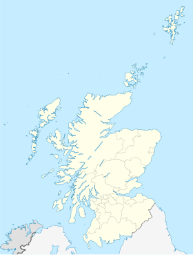
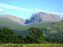
This is a list of the extreme points of the British Isles, the points that are farther north, south, east, west, higher or lower than any other location.

This is a list of extreme points of Malta. The points that are farthest north, south, east or west than any other location. Malta is composed of an archipelago of seven islands.

This is a list of the extreme points and extreme elevations in Wales.

Oktyabrsky, Oktyabrskaya or Oktyabrskoye is the name of several inhabited localities in Russia.

<span class="mw-page-title-main">Borders of the oceans</span> Limits of Earths oceanic waters

The borders of the oceans are the limits of Earth's oceanic waters. The definition and number of oceans can vary depending on the adopted criteria. The principal divisions of the five oceans are the Pacific Ocean, Atlantic Ocean, Indian Ocean, Southern (Antarctic) Ocean, and Arctic Ocean. Smaller regions of the oceans are called seas, gulfs, bays, straits, and other terms. Geologically, an ocean is an area of oceanic crust covered by water.

<span class="mw-page-title-main">Extreme points of Bhutan</span>

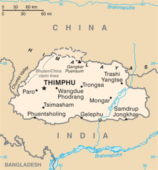
This is a list of the extreme points of Bhutan.

<span class="mw-page-title-main">Extreme points of Uruguay</span>

This is a list of the extreme points of Uruguay, the points that are farther north, south, east or west than any other location, and the highest and lowest points. It is also notable that Uruguay's northernmost point is farther south than the northernmost point of any other nation.

References

  1. "Brave hearts of Scotland". BBC. 24 October 2002. Retrieved 4 January 2010.

Notes

  1. Rockall is claimed by several countries, including the UK (as part of Scotland's Outer Hebrides). If Rockall is not considered part of the UK, then Soay, Saint Kilda, west of the Outer Hebrides, is the westernmost point.
  2. The village on Hirta, St Kilda was abandoned in 1930, and was until then the westernmost settlement in Scotland. The island now has a military base, and is staffed during the summer months.
  3. The opening of the Skye Bridge on 16 October 1995 means that Skye could be regarded as part of the British mainland, which - using this definition - would make the westernmost point of mainland Britain a spot 200 m (220 yd) south of the Neist Point Lighthouse, Skye, at 57°25′N6°47′W / 57.417°N 6.783°W .
  4. A 2002 study by the Ordnance Survey pinpointed the centre more precisely, and it is their results that are quoted here. However, this is obviously dependent on whether or not Scotland's islands are included, and there is more than one way to measure it.