
There is some debate as to the location of the geographical centre of Scotland. This is due to different methods of calculating the centre, and whether surrounding islands are included.
There is some debate as to the location of the geographical centre of Scotland. This is due to different methods of calculating the centre, and whether surrounding islands are included.
In 2002, the Ordnance Survey calculated the centre using a mathematical centre of gravity method. This is the mathematical equivalent of calculating the point at which a cardboard cut-out of Scotland could be perfectly balanced on the tip of a pin. It becomes complicated when the islands are included so one simplification is just to ignore them.

The Ordnance Survey calculated that the centre of Mainland Scotland is at NN7673153751 ( 56°39′33.86″N4°0′40.37″W / 56.6594056°N 4.0112139°W ). The point is 5 km east of the mountain of Schiehallion, which is sometimes claimed to be at the centre of Scotland.
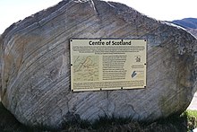
The centre point including islands was found to be at grid reference NN6678471599 ( 56°49.0153′N4°10.959′W / 56.8169217°N 4.182650°W ). This is on a hillside in Glen Garry, near the Pass of Drumochter. [1] [2]
Nearby, it is claimed that the centre lies a few miles from the village of Newtonmore, Badenoch. It is marked by a stone set into a wall. [3]
Another cruder method is to take the intersection between the line of latitude midway between the most northerly and southerly points on the Scottish mainland, and the line of longitude midway between the most easterly and westerly points. In the days when Corrachadh Mòr in Ardnamurchan was undisputedly the most westerly point, this also produced 56 degrees 39 minutes N, 4 degrees 0 minutes W, very near the summit of Schiehallion.
However the construction of the Skye Bridge, arguably turning Skye into part of the Scottish mainland, may have upset some of these calculations.
Less credible candidates for the centre of Scotland also exist. The Society of Antiquaries of Scotland in 1908 suggested the megalithic Faskally Cottages Standing Stones. [4] The Society were aware of other contenders of the centre of Scotland: "Various spots have been so designated: a site at Struan, several miles to the N.W. of Faskally; also a house on the Killiecrankie road, being the most talked of besides a house in the Fair City of Perth itself." [5]
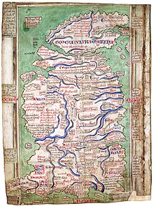
Matthew Paris's map of 1247 shows a clear north–south divide to Scotland. Proverbially Stirling is the strategically important "Gateway to the Highlands". It has been said that "Stirling, like a huge brooch clasps Highlands and Lowlands together". [6] [7] There is also and east–west divide as told in the story as recorded by Boece who relates that in 855 Scotland was invaded by two Northumbrian princes, Osbrecht and Ella. [8] They united their Northumberian Anglian forces with the Lowland Strathclyde Britons in order to defeat the Highland Pictish Scots. Having secured Stirling castle, they built the first stone bridge over the Forth. On the top they reportedly raised a crucifix with the inscription: "Anglos, a Scotis separat, crux ista remotis; Arma hic stant Bruti; stant Scoti hac sub cruce tuti." [9] It may be the stone cross was a tripoint for the three kingdom's borders or marches. [10] In this way the stone cross in the centre of Stirling Bridge was the heart of Scotland. [11]

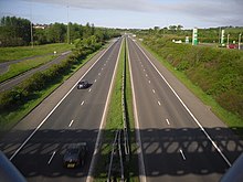
The centre of the Central Belt may also be a point of interest. The Heart of Scotland services known as Harthill is close to the centre of the M8 motorway, Scotland's main road linking East with West. Cumbernauld, also in the Central Belt, is a watershed with one of its rivers (from which its name is derived) flowing to the east and the other flowing west. This watershed test could also apply to other sites like the summit of Ben Lomond being on the line of the Scottish watershed but Cumbernauld arguably has this property in its very name. A map of Scotland's watershed has been produced for walkers. [12]
There have been other centres suggested, such as the furthest point from salt water including sea lochs. The point furthest from the Mean High Water mark is in Glen Quoich, near Braemar, in Aberdeenshire which is 67.6 km from the sea. [13] [14]
As with other topics like defining the location of the North Pole the answer largely depends on which criteria you choose.

Some have also claimed Gartincaber Tower [15] for the title. [16] Even some Stirlingshire residents consider it ahead of Stirling Bridge. [17]

Clackmannanshire, or the County of Clackmannan, is a historic county, council area, registration county and lieutenancy area in Scotland, bordering the council areas of Stirling, Fife, and Perth and Kinross. In terms of historic counties it borders Perthshire, Stirlingshire and Fife.

Stirling is a city in central Scotland, 26 miles (42 km) northeast of Glasgow and 37 miles (60 km) north-west of Edinburgh. The market town, surrounded by rich farmland, grew up connecting the royal citadel, the medieval old town with its merchants and tradesmen, the Old Bridge and the port. Located on the River Forth, Stirling is the administrative centre for the Stirling council area, and is traditionally the county town of Stirlingshire. Proverbially it is the strategically important "Gateway to the Highlands". It has been said that "Stirling, like a huge brooch clasps Highlands and Lowlands together". Similarly "he who holds Stirling, holds Scotland" is sometimes attributed to Robert the Bruce. Stirling's key position as the lowest bridging point of the River Forth before it broadens towards the Firth of Forth made it a focal point for travel north or south.

Stirlingshire or the County of Stirling is a historic county and registration county of Scotland. Its county town is Stirling.
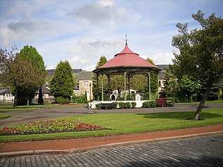
Kilsyth is a town and civil parish in North Lanarkshire, roughly halfway between Glasgow and Stirling in Scotland. The estimated population is 10,380. The town is famous for the Battle of Kilsyth and the religious revivals of the 18th, 19th, and 20th centuries. The town now has links with Cumbernauld at one time being part of Cumbernauld and Kilsyth District Council. The towns also have the same members of parliament at Holyrood and Westminster.

The National Wallace Monument is a 67 m (220 ft) tower on the shoulder of the Abbey Craig, a hilltop overlooking Stirling in Scotland. It commemorates Sir William Wallace, a 13th- and 14th-century Scottish hero.

The Central Belt of Scotland is the area of highest population density within Scotland. Depending on the definition used, it has a population of between 2.4 and 4.2 million, including multiple major Scottish settlements such as Paisley, Glasgow, East Kilbride, Livingston and Edinburgh.

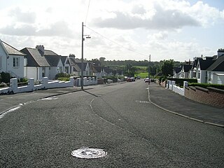
Luggiebank is a small village to the south of Cumbernauld. Like Condorrat, Castlecary and Dullatur, it predates the new town of Cumbernauld, and of those, only Condorrat was officially included in the designated area. It is situated on what used to be the Stirling Road from Lanark, but as a result of a bypass (B8039) the old road is now a cul-de-sac. Unlike the rest of Cumbernauld, which was in Dunbartonshire, Luggiebank was historically in Lanarkshire, but was adopted into Dunbartonshire in 1967, prior to Cumbernauld becoming a police burgh the following year. Following further boundary changes in 1995, Luggiebank became part of North Lanarkshire.
Stepps is a town in North Lanarkshire, Scotland, near the north-eastern outskirts of Glasgow. According to data gathered by North Lanarkshire Council in 2020, Stepps is estimated to have a population of roughly 7,700 inhabitants. Its recently upgraded amenities include a new primary school, library and sports facilities.
Camelon is a large settlement within the Falkirk council area, Scotland. The village is in the Forth Valley, 1.3 miles (2.1 km) west of Falkirk, 1.3 miles (2.1 km) south of Larbert and 2.6 miles (4.2 km) east of Bonnybridge. The main road through Camelon is the A803 road which links the village to Falkirk. At the time of the 2001 census, Camelon had a population of 4,508.

Slamannan is a village in the south of the Falkirk council area in Central Scotland. It is 4.6 miles (7.4 km) south-west of Falkirk, 6.0 miles (9.7 km) east of Cumbernauld and 7.1 miles (11.4 km) north-east of Airdrie.

Central region was a local government region from 1975 to 1996, being one of twelve such regions across Scotland. The Regional Council's headquarters were at Viewforth in Stirling, which had been previously the headquarters of Stirlingshire County Council. Since 1996 the area has been divided into the council areas of Clackmannanshire, Falkirk and Stirling, which had previously been districts within Central region.
Christian Maclagan was a Scottish antiquarian and early archaeologist. She is known for her collection of rubbings of Celtic crosses and Pictish stones from across Scotland, and was a pioneer of stratigraphic excavation. Although she lost the use of her right hand due to a medical condition she nevertheless produced numerous drawings, sketches and paintings with her left hand. She took action to help those affected by poverty in Stirling. She refused to sit for portraits although one obituary described her as tall. She was a suffragist. She wrote an autobiography but the script remains lost. She was nominated to be one of Scotland's Heroines honoured at the National Wallace Monument's Hall of Heroes. She died in Ravenscroft, Stirling.

The Battle of Barry is a legendary battle in which the Scots, purportedly led by Malcolm II, defeated a Danish invasion force in 1010 AD. Its supposed site in Carnoustie, Angus can be seen in early Ordnance Survey maps. The history of the event relies heavily on tradition and it is considered to be apocryphal. The battle was named for the Parish of Barry, rather than the village, and was formerly thought to have taken place at the mouth of the Lochty burn, in the vicinity of the area that is now occupied by Carnoustie High Street. While the battle is not historically authentic, its romantic appeal continues to capture the popular imagination.
This is a list of the extreme points and extreme elevations in Scotland.
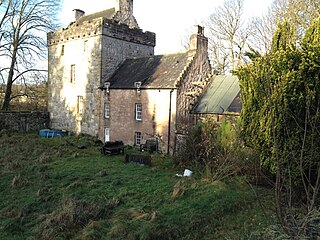
Castle Cary Castle is a fifteenth-century tower house, about 6 miles (10 km) from Falkirk, in the former county of Stirlingshire, Scotland. It is less than 3 miles from Cumbernauld Village. It is located near to the site of one of the principal forts of the Roman Antonine Wall.

Arthur's O'on was a stone building thought to be Roman temple that, until 1743, stood on rising ground above the north bank of the River Carron not far from the old Carron ironworks in Stenhousemuir, near Falkirk, Scotland. The structure is thought to be the 'stone house' which gave its name to Stenhousemuir. Early historians discussed historical and mythical associations with the site and by 1200 the estate of Stenhouse on which it stood had been named after it.
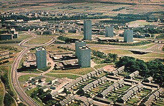
Cumbernauld is a large town in the historic county of Dunbartonshire and council area of North Lanarkshire, Scotland. It is the tenth most-populous locality in Scotland and the most populated town in North Lanarkshire, positioned in the centre of Scotland's Central Belt. Geographically, Cumbernauld sits between east and west, being on the Scottish watershed between the Forth and the Clyde; however, it is culturally more weighted towards Glasgow and the New Town's planners aimed to fill 80% of its houses from Scotland's largest city to reduce housing pressure there.

The Luggie Water is one of two streams which flow out of Cumbernauld. The Scottish New Town’s name derives from the Gaelic for "the meeting of the waters", which possibly refers to the Luggie Water and the Red Burn, both of which run through Cumbernauld but which never meet.

Cumbernauld Castle was the predecessor of Cumbernauld House in the Park in Cumbernauld. The Motte of the earliest castle survives, and stones of the second castle are incorporated in the present house.

The Red Burn is one of two main streams which flow out of Cumbernauld. The Scottish New Town’s name derives from the Gaelic for "the meeting of the waters" and there is broad agreement that one of these waters is the Red Burn.
{{cite book}}: |website= ignored (help){{cite book}}: |last2= has generic name (help)