This list of Inner Hebrides summarises a chain of islands and skerries located off the west coast of mainland Scotland. There are over 30 inhabited islands in this archipelago, of which Islay, Mull and Skye are the largest and most populous.
The islands of Scotland's west coast are known collectively as the Hebrides; the Inner Hebrides are separated from the Outer Hebrides by The Minch to the north and the Sea of the Hebrides to the south. The Inner Hebrides that lie respectively north and south of Ardnamurchan are administered by two separate local authorities as part of larger territories. The northern Inner Hebrides, including Skye, the Small Isles and the Summer Isles, are part of the Highland unitary council region. The southern group, including Islay, Jura, the Slate Islands and Gigha are part of the Argyll and Bute council region.
In the past, the Hebrides as a whole were a strong Scottish Gaelic-speaking area, and in 1921 more than 50% of the populations of most of these islands, including Skye, Mull and Islay, were proficient in the language. However, although the Outer Hebrides have retained many Gaelic speakers, in the 2001 census only Skye (31%) and Tiree (48%) had more than 25% of the resident population able to speak Gaelic; Mull, Jura, Gigha and Coll each recorded figures of less than 15%.[1]
The modern economy centres on tourism, crofting, farming, fishing, and whisky distilling. The archipelago is exposed to wind and tide. There are numerous lighthouses as an aid to navigation.[2]
There are various descriptions of the scope of the Hebrides. The Collins Encyclopedia of Scotland describes the Inner Hebrides as lying "east of The Minch", which would include any and all offshore islands. There are various islands that lie in the sea lochs, such as Eilean Bàn and Eilean Donan, that might not ordinarily be described as "Hebridean", but no formal definition exists and for simplicity they are included in this list rather than elsewhere.[3][4][Note 1]
Etymology
Various Gaelic names are used repeatedly. The suffix ay or aigh or aidh is generally from the Norse øy meaning "island". Eilean (plural: eileanan) also means "island". Beag and mòr (also bheag and mhòr) mean "little" and "big" and are often found together. Sgeir is "skerry" and often refers to a rock or rocks that lie submerged at high tide. Dubh is "black", dearg is "red" and glas means "grey" or "green". Orasaigh is from the Norse Örfirirsey meaning "tidal" or "ebb island".[5]
The inhabited islands of the Inner Hebrides had a population of 18,257 in 2001,[7] and 18,948 at the time of the 2011 census.[8] The highest peaks of the islands have names deriving from both Gaelic and Old Norse, indicating the historical importance of these two cultures. The archaeological record for the period of Viking domination during the Early Historic period is, however, limited.
In the Outer Hebrides all of the inhabited islands are now connected to at least one other island by a land transport route, but only four Inner Hebridean islands are connected by road, all to the mainland. The Clachan Bridge from Argyll to Seil was designed by Thomas Telford and dates from 1792.[6]Skye has been connected to Kyle of Lochalsh by the Skye Bridge since 1995.[9]Danna is also connected to the Tayvallich peninsula in Argyll by a stone causeway.
Eilean Bàn had a population of 2 and Eilean Donan a single resident in 2001 but none recorded a usually resident population in 2011 or 2022.[8][11] Eilean Donan is dominated by its castle and has had a connection to the mainland perhaps from as early as the 13th century. The arched bridge in use today was constructed in the early 20th century.[15]Scalpay and Tanera Mòr both had a population of 4 in 2011 but no permanent residents in 2022.[8][11]
There are 43 uninhabited Inner Hebrides with an area greater than 30 hectares (approximately 74 acres). Records for the last date of settlement for the smaller uninhabited islands are incomplete, but most of the islands listed here would have been inhabited at some point during the Neolithic, Iron Age, Early Historic or Norse periods.
In common with the other main island chains of Scotland many of the more remote islands were abandoned during the 19th and 20th centuries, in some cases after continuous habitation since prehistoric times. These places had been perceived as relatively self-sufficient agricultural economies,[16] but both island residents and outsiders later came to consider that the more remote islands lacked the essential services of a modern industrial economy.[17]
Some of the islands continue to contribute to modern culture. Staffa came to prominence in the late 18th century after a visit by Sir Joseph Banks. He and his fellow travellers extolled the natural beauty of the basalt columns in general, and in particular of the island's main sea cavern, which Banks renamed "Fingal's Cave". Many other prominent personalities visited Staffa over the next two centuries, including Felix Mendelssohn, whose Hebrides Overture brought further fame to the island.[18] During the Second World War, Gruinard was the site of a biological warfare test by British military scientists.[19] At that time there was an investigation by the British government to test both the vulnerability of Britain to attack and the possibility of attacking Germany using anthrax.[20]
The difficulties of definition are considerable in some cases. For example, Haswell-Smith (2004) treats Lunga[Note 4] as a single island, although during high tides it becomes one inhabited island and numerous uninhabited tidal islets. Another example is the smaller island of Eilean Mòr in Loch Dunvegan, which joins with nearby Eilean Dubh and Garay Island at low tides.[Note 5]
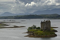
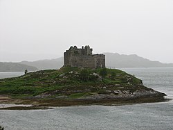
Smaller islands, tidal islets only separated at higher stages of the tide, and skerries which are only exposed at lower stages of the tide pepper the seas surrounding the main islands. Many of them are obscure and only a few have ever been inhabited. Nonetheless, some have a significant degree of notability. Lady's Rock, a skerry in Loch Linnhe, was the site of the attempted murder of Lady Catherine Campbell by her husband Lachlan Maclean of Duart in 1527. He rowed out to the rock one night at low tide and left his wife stranded on the rock to die.[30][31] Nearby Castle Stalker was in the possession of Clan Stewart of Appin at this time, but its more recent claim to fame is as a location in the film Monty Python and the Holy Grail.
Remote Dubh Artach and Skerryvore are the sites of two unmanned lighthouses; the latter reaches 48 metres (157ft) in height and is the tallest in the United Kingdom.[32]Belnahua supported a population of slate workers in its substantial and now flooded central quarry during the 19th century.[33] Nearby Eilean-a-beithich once stood in the Easdale Sound between Easdale and Seil. However, it was quarried to a depth of 76 metres (249ft) below sea level leaving only the outer rim of the island. This was eventually swept away by the sea and little visible sign of the island now remains.[34]
In addition to being a hazard to navigation, the Torran Rocks south of Erraid are one of the locations featured in the novel Kidnapped by Robert Louis Stevenson. It was here that Alan Breck Stewart and David Balfour were ship-wrecked.[35]
The smaller Inner Hebridean islands, grouped by location (from south to north), in the vicinity of:
The lighthouse at Carraig Fhada, Islay, looking towards Caolas Eilean nan Caorach, Sgeir Fhada and Sgeir Phlocach with Port Ellen at leftLooking north from Na h-Urrachann towards Rubha nam Faoilean, Scarba, with Guirasdeal, Lunga and Eilean Dubh Mòr in the Slate Islands beyond
Islay:
Mull of Oa and Laggan Bay: Eileanan Mòra, Sgeirean Buidhe Ghil
Carraig Fhada: Am Plodan, An Gànradh, Eilean nan Caorach, Sgeir Fhada, Sgeir Phlocach
Colonsay: Dubh Eilean, Eilean à Chladaich, Eilean na Brathan, Eilean Leathann, Eilean Mhártain, Eilean na Bilearach, Eilean nam Ban, Eilean nam Feannaig, Eilean Olmsa, Glas Eilean
Jura:
East coast: Eilean à Bhorra, Eilean an Rubha, Eilean Buidhe Mòr, Eilean na h-Aorinn, Eilean Traigh an Airgid, Liath Eilean, Na Cuiltean
Small Isles: Eilean Bhride, Eilean Diomhain, Eilean nan Coinnean, Eilean nan Gabhar, Pladda
Lismore: Bernera Island, Branra, Creag Island, Eilean Dubh (2), Eilean Loch Oscair, Eilean Musdile, Eilean na Cloich, Eilean nam Bàn, Eilean nam Meann, Eilean nan Caorach, Eilean nan Chaorainn, Eilean nan Gamhna, Eilean Ramsay, Inn Island, Lady's Rock, Pladda Island,
Ross of Mull south: Eilean à Chròtha, Eilean Imheir, Eilean Liath, Eilean Mòr, Eilean Nam Boc, Eilean nan Caorann, Gamhnach Mhòr, Garbh Eilean, Na Minn, Na Maoil Mhòra
Erraid: Am Baister, Eilean a' Chalmain, Eilean Dubh (2), Eilean Ghomain, Eilean nam Muc, Eilean na Seamair, Livingston's Rocks, Rankin's Rocks, Sgeir à Chobhain, Sgeir na Caillich
Torran Rocks: Dearg Sgeir, MacPhail's Anvil, Na Torrain, Torran Sgoilte, Torr an t-Saothaid
Sound of Iona: Eilean à Ghearrain, Eilean Dubh, Eilean Dubh na Ciste, Eilean Gainmheinich, Eilean nam Ban, Liath Eilean
Loch na Làthaich: Eilean an Fheòir, Eilean Bàn, Na Liathanaich
Ulva: Eilean à Bhuic, Eilean à Chaolais, Eilean an Dusain, Eilean an Righ, Eilean na Creiche, Eilean na h-Uamha, Eilean Reilean, Garbh Eilean, Geasgill Beag, Geasgill Mòr, Sgeir Feòir, Trealbhan
Sound of Mull: Eilean na Beitheiche, Eilean Rubha an Ridire, Glas Eileanan, Sgeir Chorrach
Loch Sunart: Dun Ghallain, Eilean an t-Sionnaich, Eilean à Chuilinn, Eilean à Mhuirich, Eilean Mòr, Eilean mo Shlinneag, Garbh Eilean, Glas Eilean
Càrna: Eilean an Fheidh, Eilean nan Eildean, Eilean nan Gabhar, Eilean nan Gad, Risga
Oronsay: Eilean Mòr, Sligneach Mòr
Ardnamurchan:
South coast: Eilean nan Seachd Seisrichean, Glas Eilean
North coast: Eilean Carrach, Eilean Chaluim Cille, Eilean Dubh, Eilean na h-Acairseid, Sanna Island, Sgeir à Chàm Eilein, Sgeir an Eididh, Sgeir an Rathaid, Sgeir nam Meann
Kentra Bay: Eilean an Eididh Eilean Dhònuill, Eilean Dubh, Eilean Loisgte, Eilean nan Gad
Loch Ailort: Eilean à Bhuic, Eilean à Chaolais, Eilean Buidhe, Eilean Dubh, Eilean Dubh an Aonaich, Eilean na Gualinn, Eilean nam Bairneach, Eilean nan Gabhar, Eilean nan Trom, Samalaman Island, Sgeir Glas
Loch nan Uamh: Am Fraoch-eilean, An Garbh-eilean, An Glas-eilean, Còrr Eilean, Eilean à Ghaill, Eilean Aird nam Bùth, Eilean an t-Snidhe, Eilean Ceann Fèidh, Eilean Gobhlach, Eilean nan Cabar, Eilean Port nam Murrach
Eilean Ighe: Am Fraoch-eilean, Eilean Ban, Luinga Beag, Luinga Mhòr
North Arisaig coast: An Glas-eilean, Bogh' Oitir, Rubha dà Chuain, Sgeirean na Corra-gribhich
Kyle of Lochalsh: Black Islands, Eilean à Mhal, Eileanan Dubha, Eilean na Crèadha, Eilean nan Gobhar Beag, Eilean nan Gobhar Mòr
Loch Carron: An Garbh-Eilean, Eilean an-t-Sratha, Eilean Glasiach, Eilean na Beinne, Eilean na Creige Duibhe, Eilean nan Fraoich, Eilean nan Stac, Kishorn Island, Sgeir Bhuidhe, Sgeir Fhada, Strome Islands,
Plockton: À Ghlas-leac, An Garbh-Eilean, Eilean à Bhata, Eilean à Chait, Eilean an Duine, Eilean Dubh, Eilean Dubh Dhurinis, Eilean Lagach, Eilean na Bà Beag, Eilean na Bà Mòr, Eilean nam Fiadh, Eilean na Sgeir-Feor, Eilean nan Gamhainn, Eilean Stacan, Eilean Sgreabach, Sgeir Bhuidhe
Inner Sound: An Ruadh-Eilean, Eilean Chuaig, Eilean na Bà, Eilean nan Naomh,
Loch Torridon: Eilean à Chaoil, Eilean an Inbhire Bhàin, Eilean Dùghaill, Eilean Mòr, Eilean Tioram, Sgeir Ghlas, Sgeir na Trian, Shieldaig Island
Eilean Horrisdale: Eilean Tioram, Sgeir Glas
Gairloch: Eilean an t-Sabhail, Eilean Shieldaig, Fraoch-eilean, Glas Eilean, Na Dùnain
Longa Island: None
Rubha Rèidh: An Sean Sgeir, Stac Buidhe, Stac Dubh
Priest Island: Bottle Island, Carn Deas, Carn Iar, Eilean Dubh, Glas-leac Beag, Sgeirean Glasa, Sgeir nam Mult
Tanera Beag: Eilean à Chàr, Eilean Choinaid, Eilean Fada Beag, Eilean Fada Mòr, Glas-leac Mòr, Sgeir an Aon Iomairt, Sgeir Loisgte, Sgeir nam Feusgan, Sgeir Ribhinn, Stac Mhic Aonghais
Tanera Mor: Eilean à Bhuic, Eilean Beag, Eilean Mòr, Eilean na Saille
Enard Bay: À Chleit, Eilean Mòineseach, Eilean Mòr, Fraochlan, Green Island, Rubha à Bhrocaire, Sgeir Bhuidhe, Sgeir Ghlas Bheag, Sgeir Ghlas Mhòr, Sgeir nam Boc
The islets east of Oldany with Mòr Eilean in the foregroundThe Kylesku bridge crossing the Loch a' Chàirn Bhàin narrows with Garbh Eilean in the foreground.
Oldany: Bogh' an Tairbh, Eilean Chrona, Eilean na Ligheach, Eilean nam Boc, Eilean nan Gobhar, Eilean nan Uan, Mòr Eilean, Sgeir nan Gall
Eddrachillis Bay: An Calbh, Eilean à Bhuic, Eilean Rairidh, Meall Beag, Meall Mòr, Sgeir à Chlaidheimh
Badcall Bay: Dubh Sgeir, Eilean à Bhreitheimh, Eilean Garbh, Eilean na Bearachd, Eilean na Rainich, Eilean Riabhach, Glas Leac, Meall Earca, Ox Rock
Loch a' Chàirn Bhàin: Eilean à Ghamhna, Eilean na Furaradh, Eilean na Rainich, Garbh Eilean
Loch Glencoul: Creag Bàgh an Liath Bhaid, Eilean à Chon' à Chreige, Eilean à Chumhainn, Eilean an Tighe, Eilean an Tuim, Eilean Àrd, Eilean na Moine
Loch Dhrombaig: Cul Eilean, Eilean an Achaidh, Sgeir Liath,
Handa: Eilean an Aigeich, Glas Leac, Sgeirean Glasa
Loch Laxford: Dubh Sgeirean, Eilean à Chadh-fi, Eilean à Mhadaidh, Eileanan Dubha, Eilean an Eireannaich, Eilean an t-Sithein, Eilean Àrd, Eilean Dubh an Teoir, Eilean Dubh na Fionndalach Bige, Eilean Dubh nam Boc, Eilean Meall à Chaorainn, Eilean na Carraig, Eilean na Saille, Eilean Port à Choit, Glas Leac, Rubh' à Cheathraimh Ghairbh, Sgeirean Cruaidhe, Sgeir Eorna, Sgeir Fhanda, Sgeir Iosal, Sgeir Ruadh
Kinlochbervie: Eilean à Chonnaidh, Eilean Dubh, Glas Leac, Na Clusnadh
Eilean an Ròin Mòr: Dubh Sgeir, Eilean an Ròin Beag, Eilean na h-Aiteg, Na Stacan, Seana Sgeir
↑The definition of an island used in this list is that it is "land that is surrounded by seawater on a daily basis, but not necessarily at all stages of the tide, excluding human devices such as bridges and causeways". Other definitions are used in the Scottish context. For example, the General Register Office for Scotland define an island as "a mass of land surrounded by water, separate from the Scottish mainland" but although they include islands linked by bridges etc. this is not clear from this definition. Haswell-Smith (2004) uses "an Island is a piece of land or group of pieces of land which is entirely surrounded by water at Lowest Astronomical Tide and to which there is no permanent means of dry access". This is widely agreed to be unhelpful as it intentionally excludes bridged islands.
12Geographically, the inhabited islands can easily be separated into those that are or surround Islay, Gigha, Mull, and Skye or are in the Small Isles, Slate Islands, Firth of Lorn, Crowlin Islands, Summer Isles, one of the major sea lochs or the North Highland group.
↑Although obviously inhabited at the time (there is a hotel on the island) the General Registers Office did not provide a population total for this tidal island in either the 2001 or 2011 censuses.
↑Indicates the last known date of permanent, year round settlement[22]
↑There are no historical records of inhabitation although there are the ruins of an "ancient fort".[24]
↑There are the ruins of a "small cell", perhaps once used by an anchorite.[25]
↑The Census indicates a population of 3 in 1931 and nil in 1961. A mill was operated on the island until 1948 and abandonment is assumed when it closed and the associated buildings and wharves were dismantled.[26][27]
↑The Gaelic etymology is disputed. It may have been called Oideach by Adomnan and was referred to as "Ilantasson" (i.e. "island Tasson") in 1624.[28]
↑This island is in the Sound of Kerrera at grid referenceNM841293 but is not named by the Ordnance Survey. The name is confirmed by Oban Sailing Club.[36]
↑This refers to the historic county of Argyll rather than the modern council area of Argyll and Bute. Since 1996 this section has been in the Highland council area.
Citations
↑Mac an Tàilleir, Iain 1901–2001 Gaelic in the Census, PowerPoint Presentation made available via Linguae Celticae. Retrieved 1 June 2008.
↑Encyclopædia Britannica (1978) states: "Hebrides – group of islands of the west coast of Scotland extending in an arc between 55.35 and 58.30 N and 5.26 and 8.40 W." This includes Gigha, St Kilda and everything up to Cape Wrath – although not North Rona.
12Haswell-Smith (2004) and Ordnance Survey maps. Blanks indicate that no name is recorded for this eminence.
123Ordnance Survey maps mark the height above sea level of a high point on most islands, but in a small number of cases, this may not be the highest point.
↑Osborne, Roy. "The Isle Martin Trust". Caledonia Centre for Social Development. Archived from the original on 15 June 2021. Retrieved 28 December 2009.
This page is based on this Wikipedia article Text is available under the CC BY-SA 4.0 license; additional terms may apply. Images, videos and audio are available under their respective licenses.