
In archaeology, a broch is an Iron Age drystone hollow-walled structure found in Scotland. Brochs belong to the classification "complex Atlantic roundhouse" devised by Scottish archaeologists in the 1980s.

Trotternish or Tròndairnis is the northernmost peninsula of the Isle of Skye, in Scotland. Its most northerly point, Rubha Hùinis, is the most northerly point of Skye.

Scotland is the most mountainous country in the United Kingdom. Scotland's mountain ranges can be divided in a roughly north to south direction into: the Scottish Highlands, the Central Belt and the Southern Uplands, the latter two primarily belonging to the Scottish Lowlands. The highlands eponymously contains the country's main mountain ranges, but hills and mountains are to be found south of these as well. The below lists are not exhaustive; there are countless subranges throughout the country.
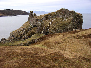
Dunscaith Castle also known as Dun Scaich, Dun Sgathaich Castle and Tokavaig, is a ruined castle on the coast of the Isle of Skye, in the north-west of Scotland. It is located in the Parish of Sleat, in the Highland council area, and in the former county of Inverness-shire, at grid reference NG595120. Also called "Fortress of Shadows", it is the legendary home of the warrior maiden Scáthach, after whom it is named. It is protected as a scheduled monument.
Pabay is a Scottish island just off the coast of Skye. The name Pabay is derived from an old Norse word meaning "priest's isle" and there are the remains of a 13th-century chapel.
Kirkmaiden is a parish in the Rhins of Galloway, the most southerly in Scotland; the present Church of Scotland parish has the same name as and is approximately coterminous with the original pre-Reformation parish.

Dun Ringill is an Iron Age hill fort on the Strathaird peninsula on the island of Skye, Scotland. Further fortified in the Middle Ages, tradition holds that it was for several centuries the seat of Clan MacKinnon. It is located east of Kirkibost on the west shore of Loch Slapin.
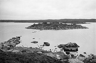
Dùn Anlaimh, also known as Dùn Amhlaidh, and Eilean nan Cinneachan, is a crannog, located within Loch nan Cinneachan on the Inner Hebridean island of Coll. Upon the crannog there are the remains of walls and several buildings. These remains are not unlike those of other fortified islands found throughout the Outer Hebrides, and it is likely that Dùn Anlaimh dates from the late Middle Ages. According to local tradition on Coll, the fort was once the home of a Norse chieftain who was defeated in battle somewhere nearby. The early 20th century antiquary Erskine Beveridge considered it as one of the four most interesting fortifications, on Coll. The site of Dùn Anlaimh is located at grid reference NM18845684. The RCAHMS classifies the site as a 'crannog' and an 'island dwelling'.

Dùn Beic is a dun located on the Inner Hebridean island of Coll. It is located at grid reference NM15495644 and is thought to date to between 1000 BCE to 1000 CE. The etymology of the dun's name is uncertain; one possibility is that it could be made up of a personal name. The dun appears in local legend as being one of several fortresses held by Norsemen, who were defeated in battle against the ancestor of the Macleans of Coll. There have been several archaeological finds at Dùn Beic; these include pieces of flint, burnt bone, and fragments of incised pottery.
An Caisteal is a hill fort located on the island of Coll. This island is one of the islands which make up the Inner Hebrides located on the west coast of Scotland. The fort is located at grid reference NM17185815. Located 1,200 yards (1.1 km) to the north-east of An Caisteal is Dùn Foulag. Dùn Foulag, located at grid reference NM17505908, was once thought to be a dun, though it is now considered to be only a naturally rocky knoll.

Bernera Barracks is in Glenelg in the West Highlands of Scotland. The barracks were constructed between 1717 and 1723 as part of a campaign by the British government to subdue the local population which had risen up in arms in the Jacobite Rising of 1715, and which would do so again in 1745. The barracks were designed by Andrews Jelfe and John Lambertus Romer of the Board of Ordnance, or possibly their predecessor James Smith, and built by Sir Patrick Strachan. Some of the stone used in the construction was taken from Dun Telve and Dun Troddan, nearby iron-age brochs. The Government troops who were garrisoned here during the Jacobite uprisings were also intended to control the crossing to Skye. Following the 1715 rising, Glenelg was chosen along with Fort George, Fort Augustus and Fort William as one of four sites in the Highlands for military barracks.

Rubha an Dùnain or Rubh' an Dùnain is an uninhabited peninsula to the south of the Cuillin hills on the Isle of Skye in Scotland. It contains unique archaeological sites which in 2017 were designated as a historic monument of national importance by Historic Environment Scotland.

Dunbeg Fort is a promontory fort built in the Iron Age near the modern village of Ventry in County Kerry, Ireland.

The architecture of Scotland in the Roman era includes all building within the modern borders of Scotland, from the arrival of the Romans in northern Britain in the first century BCE, until their departure in the fifth century CE. Ptolemy indicated that there were 19 "towns" in Caledonia, north of the Roman province of Britannia, but no clear evidence of urban settlements has been found and these were probably hillforts. There is evidence of over 1,000 such forts, most south of the Clyde-Forth line, but the majority seem to have been abandoned in the Roman period. There is also evidence of distinctive stone wheelhouses and small underground souterrains.

Dun an Sticir is an Iron Age broch situated approximately 9.5 kilometers north of Lochmaddy in a loch on North Uist in the Scottish Outer Hebrides. A building was erected on the site in the late medieval period.

Dun Ardtreck is a D-shaped dun, or "semi-broch", located on the west coast of the island of Skye, in Scotland.

Dun Hallin is an Iron Age broch located near the northwest coast of the island of Skye, in Scotland.
Dun Evan or the Doune of Cawdor is a hill fort located 2.5 kilometres (1.6 mi) south west of Cawdor in the Highland area of Scotland. It is situated on a rocky hill that rises to 678 feet (207 m) above ordnance datum between the valleys of the River Nairn and its tributary the Allt Dearg. The site has a wide view in all directions, extending to the mouth of the River Nairn at the town of Nairn, 7 miles to the north east on the shore of the Moray Firth. Dun Evan is scheduled by Historic Environment Scotland as a site of national importance.

Dunearn is a hill fort located 15 kilometres (9.3 mi) south south east of Nairn in Highland, Scotland. It is situated on a steep-sided hill called Doune rising to approximately 266 metres (873 ft) above ordnance datum just south of Dulsie Bridge in the parish of Ardclach.

Dun Cruinn is a prehistoric site about 10 kilometres (6.2 mi) north-west of Portree, on the Isle of Skye, Scotland. It is on the Skerinish Peninsula, between Loch Snizort Beag and Loch Eyre.

