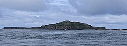
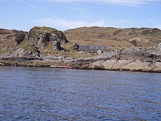
Lunga, which is of volcanic origin, has been described as 'a green jewel in a peacock sea'.[3] It was inhabited until the 19th century, and still bears the remains of blackhouses. The remains of the ruined village, abandoned in 1857, lie in the northeastern part of the island.[7]
Wildlife
Puffins on Lunga.Seabirds on Harp Rock, Lunga, Treshnish Isles
In summer, tourist boats visit Lunga from Ulva Ferry, Tiree, Tobermory, Iona and Ardnamurchan. The island's thousands of breeding puffins, who allow visitors to approach to within a few feet of them, are the island's main attraction.
A Puffin sitting side on to camera, on the cliff top where its nest is.
The Small Isles are a small archipelago in the Inner Hebrides, off the west coast of Scotland. They lie south of Skye and north of Mull and Ardnamurchan – the most westerly point of mainland Scotland.
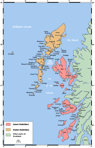
The Inner Hebrides is an archipelago off the west coast of mainland Scotland, to the south east of the Outer Hebrides. Together these two island chains form the Hebrides, which experience a mild oceanic climate. The Inner Hebrides comprise 35 inhabited islands as well as 44 uninhabited islands with an area greater than 30 hectares. Skye, Mull, and Islay are the three largest, and also have the highest populations. The main commercial activities are tourism, crofting, fishing and whisky distilling. In modern times the Inner Hebrides have formed part of two separate local government jurisdictions, one to the north and the other to the south. Together, the islands have an area of about 4,130 km2 (1,594 sq mi), and had a population of 18,948 in 2011. The population density is therefore about 4.6 inhabitants per square kilometre.
Staffa is an island of the Inner Hebrides in Argyll and Bute, Scotland. The Vikings gave it this name as its columnar basalt reminded them of their houses, which were built from vertically placed tree-logs.
The Isle of Noss or Noss is a small, previously inhabited island in Shetland, Scotland. Noss is separated from the island of Bressay by the narrow Noss Sound. It has been run as a sheep farm since 1900, and has been a national nature reserve since 1955.
Handa Island or usually Handa, is an island in Eddrachillis Bay off the west coast of Sutherland, Scotland. It is 309 hectares and 123 metres (404 ft) at its highest point.
The Garvellachs or Isles of the Sea form a small archipelago in the Inner Hebrides of Scotland. The islands include Garbh Eileach, Dùn Chonnuill and Eileach an Naoimh. Part of the Argyll and Bute council area, they lie in Firth of Lorne west of Lunga and northwest of Scarba and have been uninhabited since the 19th century.
Scarba is an island, in Argyll and Bute, Scotland, just north of the much larger island of Jura. The island has not been permanently inhabited since the 1960s. Until his death in 2013 it was owned by Richard Hill, 7th Baron Sandys; its owner now is Shane Cadzow who farms Luing cattle on the nearby island of Luing and grazes some of the cattle on Scarba. Kilmory Lodge is used seasonally as a shooting lodge, the island having a flourishing herd of red deer.
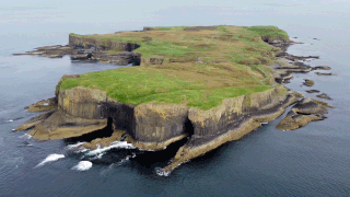
The Treshnish Isles are an archipelago of small islands and skerries, lying west of the Isle of Mull, in Scotland. They are part of the Inner Hebrides. Trips to the Treshnish Isles operate from Ulva Ferry, Tobermory, Ardnamurchan and Tiree.
Garbh Eileach is an uninhabited island in the Inner Hebrides of the west coast of Scotland that lies in the Firth of Lorn between Mull and Argyll. With an area of 142 ha it is the largest of the Garvellachs and reaches a maximum elevation of 110 m (361 ft) above sea level.
Eilean Dubh Mòr is an uninhabited island in the Inner Hebrides of Scotland. It lies at the mouth of the Firth of Lorn, between the islands of Lunga and Garbh Eileach. The area of the island has been measured variously—at 50 hectares by Livingstone and 65 hectares by Haswell-Smith, the latter including the nearby islet of Eilean Dubh Beag, which is joined to Eilean Dubh Mòr at low tide.
Lunga is one of the Slate Islands in the Firth of Lorn in Argyll and Bute, Scotland. The "Grey Dog" tidal race, which runs in the sea channel to the south, reaches 8 knots (15 km/h) in full flood. The name "Lunga" is derived from the Old Norse for "isle of the longships', but almost all other place names are Gaelic in origin.
Bac Mòr is a Scottish island, one of the Treshnish Isles, sometimes referred to as The Dutchman's Cap in English because of its shape.
Bac Beag is a Scottish island, one of the Treshnish Isles in the Inner Hebrides.
Cairn na Burgh Mòr is one of the Treshnish Isles in the Inner Hebrides of Scotland.
Fladda is the northernmost of the Treshnish Isles. Its name comes from the Old Norse Flat-ey meaning "flat island". Fladda is owned by the Hebridean Trust.
Garbh Eilean is one of the Shiant Islands at the south end of the Minch on the west coast of Scotland.
Cairn na Burgh Beag is one of the Treshnish Isles in the Inner Hebrides, Scotland.
The flora and fauna of the Outer Hebrides in northwest Scotland comprises a unique and diverse ecosystem. A long archipelago, set on the eastern shores of the Atlantic Ocean, it attracts a wide variety of seabirds, and thanks to the Gulf Stream a climate more mild than might be expected at this latitude. Because it is on the Gulf Stream, it also occasionally gets exotic visitors.
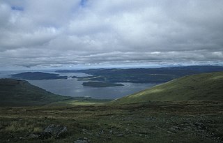
Loch na Keal, meaning Loch of the Kyle, or Narrows, also Loch of the Cliffs, is the principal sea loch on the western, or Atlantic coastline of the island of Mull, in the Inner Hebrides, Argyll and Bute, Scotland. Loch na Keal extends over 20 kilometres (12 mi) inland, almost bisecting Mull, and extending to within 5 km (3 mi) of the eastern shore. The loch gives its name to the Loch na Keal National Scenic Area, one of forty national scenic areas in Scotland.
The Norrard (Northern) Rocks are a group of small uninhabited granite rocks in the north–western part of the Isles of Scilly, to the west of Bryher and Samson. In 1971 they were designated as a Site of Special Scientific Interest (SSSI) for their breeding seabird colonies and they are permanently closed to landings from boat passengers. The vegetation on the islands is limited by the extreme exposure and only six species of flowering plants have been recorded.
This page is based on this Wikipedia article Text is available under the CC BY-SA 4.0 license; additional terms may apply. Images, videos and audio are available under their respective licenses.