The freshwater islands in Scotland include those within freshwater lochs and rivers – including tidal areas, so the islands may not always be surrounded by freshwater. It has been estimated that there are at least 31,460 freshwater lochs in Scotland and that 1.9 per cent of the land surface is covered by freshwater. The distribution has a north-west to south-east gradient, with the highest concentrations occurring on the islands of the Outer Hebrides.[2][Note 1]
Various names are used repeatedly. "Inch" or Innis is a Scots word that can mean 'island' (although it is also used for terra firma surrounded by marsh). Similarly, Eilean is the Gaelic for 'island'. A common suffix for offshore islands in the north of Scotland is "-holm", derived from the Old Norseholmr, meaning a 'small and rounded islet'.[12][13][14] This list excludes artificial crannógs and the numerous small freshwater islands with no recorded name.[Note 3][Note 4]
Larger islands
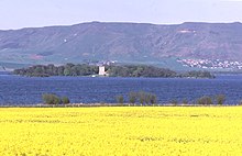
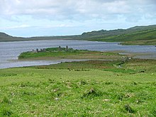
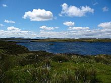
Inchmurrin in Loch Lomond, Scotland's largest freshwater islandThe islands of Loch Maree
This table includes all of the freshwater islands that exceed 35 hectares (86 acres) in size and/or are populated.
Inchlonaig and Inchcruin[Note 5] are classified by the National Records of Scotland as "inhabited islands but had no usual residents at the time of either the 2001 or 2011 censuses."[17] It is likely that Eilean Aigas is inhabited, at least from time to time as well, although it was not listed as such by the Census in 2001[19] or 2011.[citation needed]
Loch Awe is Scotland's longest loch and abounds with islands and crannógs. Several of the islands are, or have in the past, been inhabited; there are two castles and the remains of a chapel on the islands.[20] Inistrynich, Eilean na Maodail, Eilean Dubh and Liever Island are all promontories as opposed to islands despite their names. The loch's water levels have fluctuated so some of them may have been islands in recent history, as the promontory on which Kilchurn Castle stands once was.[21]
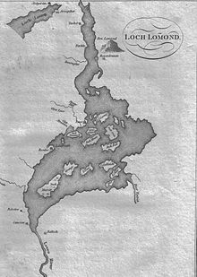
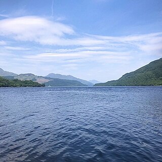
There may be up to sixty islands in the Loch Lomond including Inchmurrin, the largest freshwater island anywhere in the Britain and Ireland, and Inchconnachan, which has hosted a small population of Red-necked Wallaby since at least 1975.[22][23] The isolated strongholds of Lochindorb Castle and Loch an Eilein Castle were once in the hands of the 14th century nobleman Alexander Stewart, the infamous "Wolf of Badenoch".[24][25] There are numerous unnamed small islands in mainland lochs, including those where the water level has been artificially raised by the creation of dams for the production of hydro-electricity. This process has created new islands that would previously have been small eminences.[citation needed][26]
Castle Isle – previously a promontory prone to flooding prior to the raising of the water level in the 1930s. Many islands, islets and named rocks were submerged when the loch was raised including Pickmaw Isle, Wee Pickmaw Isle, Garpel Islands, Gull Islands, Dun Cow, Whale's Back, Watts Island, Saugh Island, Gordon's Island, Glede Stone, Ford of Moak. Ruined buildings on both Castle Island (a separate island from Castle Isle) and Donalds Isle remain visible above the waterline.
Although there are many crannógs in the lochs of the Inner Hebrides there are relatively few substantive, naturally occurring islands and of those that exist many are unnamed.[Note 11] By contrast there are innumerable small islands in the estimated 7,500 lochs of the Eilean Siar,[2] only a small proportion of which are named by the Ordnance Survey.[citation needed]
The Orkney and Shetland archipelagos to the north are similarly lacking in freshwater islands. Law Ting Holm is the former location of the national þing, or Norse parliament of Shetland.[28][unreliable source?]
No part of Scotland is more than 80.4 kilometres (50mi) from the sea[34][unreliable source?] and as a result Scotland's rivers are neither very wide nor long (although Scotland has many substantial salt water estuaries called firths). These are islands in freshwater, or where indicated, occasionally reached by high tides and in brackish water.[citation needed]
Moncreiffe Island (b), Insherrit Island (b), The Scone Isles, The Stanners (b)
There are several former islands in the Tay, created by natural silting and artificial reclamation including: Big Island, Bloody Inches near Murthly, North Inch and South Inch in Perth, Richards Islands, Sleepless Inch and The Inch near Inchtuthil.[Note 23]
Barrow, G.W.S. (ed.), The Kingdom of the Scots: Government, Church and Society from the Eleventh to the Fourteenth Century (2003) Edinburgh University Press. ISBN0-7486-1803-1
Coventry, Martin (2008) Castles of the Clans. Musselburgh. Goblinshead. ISBN978-1-899874-36-1
Grant, Alexander "The Wolf of Badenoch" in W.D.H. Sellar (ed.) (1993) Moray: Province and People. Scottish Society for Northern Studies. Edinburgh; ISBN0-9505994-7-6
↑ Some of the islets in Loch Lomond may only appear when the water levels are low[8][unreliable source?] and although many sources provide a figure of up to sixty islands[9][unreliable source?] this may derive from a poetic 9th century description. Other sources suggest a total of 30 or 38 islands.[10][11]
↑ Crannógs are excluded as they are both artificial and very numerous. There are at least 600 of these small prehistoric structures in Scotland.[15]
↑ There is a significant difference between the Ordnance Survey (OS) treatment of freshwater and offshore islands. See for example Loch Snigiscleit at grid referenceNF802254. If the islands here were offshore it is virtually certain that there would be three substantial named islands and probably half a dozen named smaller ones. There are several examples – Loch Druidibeag has two named islands and about a dozen un-named. It is not clear whether this because the OS only chose to list a few larger ones and those identified by RCAHMS, or if for some reason local people did not give names to smaller islands in lochs. The latter is unlikely although these islands offer much less of threat to fishermen and thus there is less of an imperative to be aware of them.[original research?]
↑ Referred to by the National Records of Scotland (2013) as "Inchruin", which is presumably a typographical error.[original research?]
↑ As there are numerous lochs in Highland, which is large council area covering over 30,000 square kilometres (12,000sqmi) the area committee designations of Badenoch and Strathspey, Caithness, Inverness, Lochaber, Nairn, Ross and Cromarty, Skye and Lochalsh and Sutherland are used to identify the location.
↑ Numbers in brackets indicate that there are (2) or (3) islands of the same name in the body of water referred to.
↑ An island dwelling on Eilean an Righ is said to have been the site of King Fergus's hunting lodge. An insubstantial neighbouring island, Eilean nan Con or Eilean n'Cone, is now no longer in evidence and was said to have been where the king's dogs were kennelled.
↑ Rainish Eilean Mòr at grid referenceNB388281 is about 27 hectares (67 acres) in extent. This makes it one of the larger freshwater islands, but it is probably the largest relative to the size of the body of water it sits in, Loch Orasaigh being only about 125 hectares (310 acres) all told.
↑ Eilean nan Cnàmh is in Loch nam Faoileag, an arm of Loch Trealalabhal separated from the main body by a causeway. The former loch is "commonly regarded" as part of the latter.[30]
↑ This loch is not specifically named by the Ordnance Survey and at one time it may have been an extension of the saltwater Loch Boisdale. Its size has been enhanced artificially in that a small dam has been constructed, probably to prevent brackish water entering from Poll a' Fearchadh.[31][original research?]
↑ This islet is now attached to Mainland Shetland by a stone causeway.[33]
↑ This islet is now attached to Mainland Shetland by a stone causeway.[28]
↑ (b) Indicates those that from time to time lie in brackish water, as indicated by the Ordnance Survey as lying below the "Mean High Water Springs".
↑ Canny Island at NT891467 is in the middle of the Tweed but on the English side of the border as identified by the Ordnance Survey.
↑ Kippie Island is in the middle of the Tweed on the Scottish side of the border as identified by the Ordnance Survey but is conjoined to Dreeper Island which is on the English side. Historical OS maps show that the channel between the two, once separate, islands narrowed progressively eventually closing sometime between 1922 and 1967.
↑ North and South Inch are reclaimed parks on the right bank of the Tay, now within the bounds of the town of Perth.[35] Sleepless Island is now a sewage works at NO146220[36] Bloody Inches is at NO139391 and The Inch at NO106391. Big Island is a former gravel bank at NN992494 and Richards Islands are further upstream on the River Tummel (a tributary of the Tay) at NN955557[37][38][39]
Loch Lomond is a freshwater Scottish loch which crosses the Highland Boundary Fault, often considered the boundary between the lowlands of Central Scotland and the Highlands. Traditionally forming part of the boundary between the counties of Stirlingshire and Dunbartonshire, Loch Lomond is split between the council areas of Stirling, Argyll and Bute and West Dunbartonshire. Its southern shores are about 23 kilometres (14 mi) northwest of the centre of Glasgow, Scotland's largest city. The Loch forms part of the Loch Lomond and The Trossachs National Park which was established in 2002.
Loch Rannoch is a freshwater loch in Perth and Kinross, Scotland. It is over 15 kilometres (9.3 mi) long in a west–east direction with an average width of about 1.2 kilometres (0.75 mi), and is deepest at its eastern end, reaching a depth of 130 metres (440 ft). The River Tummel begins at its eastern end, where the small village of Kinloch Rannoch can be found, whilst the wild expanse of Rannoch Moor extends to the west of the loch. The area surrounding Loch Rannoch, along with Rannoch Moor itself, was formerly part of the native Caledonian Forest that stretched across much of Northern Scotland. Native forest is now largely absent from much of the area, due partly to logging, and partly to the climate becoming wetter, and Loch Rannoch is now largely surrounded by commercial forestry and open hillsides, although a small area remains at the Black Wood of Rannoch on the southern shore of the loch.
Loch Tay is a freshwater loch in the central highlands of Scotland, in the Perth and Kinross and Stirling council areas. It is the largest body of fresh water in Perth and Kinross, and the sixth largest loch in Scotland. The watershed of Loch Tay traditionally formed the historic province of Breadalbane.
The Burnt Islands are three small islands that lie in the Kyles of Bute, on the Cowal Peninsula, Argyll and Bute, on the West coast of the Scottish mainland. The islands are located at grid reference NS017752.
Kenmore is a small village in Perthshire, in the Highlands of Scotland, located where Loch Tay drains into the River Tay.
Inchmurrin is an island in Loch Lomond in Scotland. It is the largest fresh water island in the British Isles.
Loch Tummel is a long, narrow loch, seven kilometres northwest of Pitlochry in the council area of Perth and Kinross, Scotland. It is fed and drained by the River Tummel, which flows into the River Tay about 13 km (8 mi) south-east of the Clunie Dam at the loch's eastern end.
Inchcailloch is an islet on Loch Lomond in Scotland. It is 85 metres (279 ft) at its highest point. It is also known to some as Inchebroida.
This is a list of islands called Eilean Fraoch or Fraoch Eilean, which provides an index for islands in Scotland with this and similar names. Literally meaning "heather island" in Scottish Gaelic, it is a common Scottish island name. It may also represent the forename "Fraoch" from Gaelic mythology.
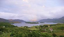
Eilean Sùbhainn is the largest of several small islands in Loch Maree, Wester Ross, Scotland. It is the second largest freshwater island in Scotland after Inchmurrin.
This is a list of islands in Scotland with the name Garbh Eilean or similar, meaning "rough island" in Scottish Gaelic.
Loch Kinord is a small, freshwater loch at Muir of Dinnet, Aberdeenshire, Scotland just north of the River Dee and 5 mi (8 km) east of Ballater. The loch is also known as Loch Ceander and Loch Cannor. It is approximately 1 mi (1.6 km) in length and was formed from a glacial kettle hole. The loch sits within the Muir of Dinnet National Nature Reserve and is immediately south of Loch Davan.
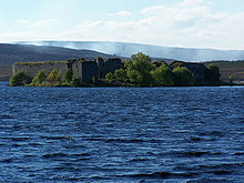
Island I Vow is a wooded islet near the head of Loch Lomond in west-central Scotland. It is 10 m tall at its highest point, and 80 m long. The island contains the remains of a castle built by the chief of Clan MacFarlane in 1577. This became the chief's primary residence after the destruction of Inveruglas Castle further down the loch, but it fell into ruin after the chief moved to the mainland.
Loch Ness is a large freshwater loch in the Scottish Highlands extending for approximately 37 kilometres southwest of Inverness. It takes its name from the River Ness, which flows from the northern end. Loch Ness is best known for claimed sightings of the cryptozoological Loch Ness Monster, also known affectionately as "Nessie". It is one of a series of interconnected, murky bodies of water in Scotland; its water visibility is exceptionally low due to the high peat content of the surrounding soil. The southern end connects to Loch Oich by the River Oich and a section of the Caledonian Canal. The northern end connects to Loch Dochfour via the River Ness, which then ultimately leads to the North Sea via the Moray Firth.
Eilean Hoan is an island in Loch Eriboll in Sutherland on the north coast of Scotland. It is about 28 hectares in extent and the highest point is 25 metres (82 ft) above sea level. Its name is of Gaelic and Old Norse derivation and means "haven island".
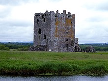
Loch of Avich is a large freshwater loch that lies approximately 1 mi (1.6 km) west of Loch Awe in Argyll and Bute in Scotland. It is the second biggest loch in the Etive basin after Loch Awe. It trends east-northeast, west-southwest and is narrowly triangular in shape. At the southwest end of the loch is the islet Innis Luana on which stands the ruins of an ancient castle named Caisteal na Nighinn Ruaidhe. The castle may have been the original seat of Clan Campbell. Near the north shore on the islet of Eilean Fraoch is the remains of a crannog.
This page is based on this Wikipedia article Text is available under the CC BY-SA 4.0 license; additional terms may apply. Images, videos and audio are available under their respective licenses.