Badenoch is a traditional district which today forms part of Badenoch and Strathspey, an area of Highland Council, in Scotland, bounded on the north by the Monadhliath Mountains, on the east by the Cairngorms and Braemar, on the south by Atholl and the Grampians, and on the west by Lochaber. The capital of Badenoch is Kingussie.

Kingussie is a small town in the Badenoch and Strathspey ward of the Highland council area of Scotland. Historically in Inverness-shire, it lies beside the A9 road, although the old route of the A9 serves as the town's main street which has been bypassed since 1979. Kingussie is 42 miles south of Inverness, 12 mi (19 km) south of Aviemore, and 3 mi (5 km) north of Newtonmore.

HMS Loch Insh was a Loch-class frigate of the Royal Navy, named after Loch Insh in Scotland. She was built by Henry Robb of Leith and launched on 10 May 1944. After service at the end of World War II she was decommissioned, but reactivated in 1950 and served, mostly in the Persian Gulf, until 1962. The ship was sold to the Royal Malaysian Navy in 1963, and renamed KD Hang Tuah (F433). She was scrapped in 1977.

Loch Long is a body of water in Argyll and Bute, Scotland. The Sea Loch extends from the Firth of Clyde at its southwestern end. It measures approximately 20 miles in length, with a width of between one and two miles. The loch also has an arm, Loch Goil, on its western side.

Cairngorms National Park is a national park in northeast Scotland, established in 2003. It was the second of two national parks established by the Scottish Parliament, after Loch Lomond and The Trossachs National Park, which was set up in 2002. The park covers the Cairngorms range of mountains, and surrounding hills. Already the largest national park in the United Kingdom, in 2010 it was expanded into Perth and Kinross.
The River Spey is a river in the northeast of Scotland. At 98 mi (158 km) it is the eighth longest river in the United Kingdom, as well as the second longest and fastest-flowing river in Scotland. It is important for salmon fishing and whisky production.

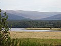
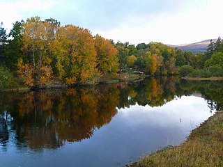
Insh Marshes are an area of floodplain of the River Spey between Kingussie and Kincraig in Badenoch and Strathspey, Highland, Scotland. The marshes are said to be one of the most important wetlands in Europe. They lie at altitude of approximately 240 to 220 m above sea level, and form one of the largest areas of floodplain mire and fen vegetation in Scotland.

Loch Morlich is a freshwater loch in the Badenoch and Strathspey area of Highland, Scotland near Aviemore. The loch is home to a watersports centre with kayaking, sailing and windsurfing among the activities available. There is also a yacht club and cycling routes around the loch. The loch is at the foot of the Cairngorm mountains, just a few miles from Aviemore. As seen on Game of Thrones Season 5.

Kenmore is a small village in Perthshire, in the Highlands of Scotland, located where Loch Tay drains into the River Tay.
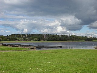
Strathclyde Country Park is a country park located on the outskirts of Motherwell in North Lanarkshire, Scotland, named after the former Strathclyde region of Scotland. It is often commonly referred to as Strathclyde, or simply Strathy.
Acharn is a hamlet in the Kenmore parish of the Scottish council area of Perth and Kinross. It is situated on the south shore of Loch Tay close to its eastern end. The hamlet was built in the early 19th century to house workers from the surrounding estates. A watermill was constructed to harness the power of the nearby Acharn Burn, and this was converted into a craft centre in the 1970s, and later into a private residence. There is a bridge in the middle that goes over the Acharn burn.

Dalwhinnie is a small village in the Scottish Highlands. Dalwhinnie is located at the head of Glen Truim and the north-east end of Loch Ericht, on the western edge of the Cairngorms National Park.
The Diocese of Moray was one of the most important of the medieval dioceses of the Roman Catholic Church in Scotland. Its territory was in central northern Scotland.
Kincraig is a village located north of Kingussie and south of Aviemore in Highland, Scotland. Its original name was Boat of Inch, reflecting the ferry boat crossing of the Spey River that once operated here. The name was changed after a single track bridge was erected around 1871.
Insh is a village in Highland, Scotland that lies on the east coast of the Insh Marshes. It is in the Badenoch and Strathspey area, around 3+1⁄2 miles east of Kingussie, in the Spey valley. It is located in historic Inverness-shire. The B970 road from Kingussie to Kincraig and Aviemore passes through the village. At the other side of the valley is the major A9 road from Inverness to the Central Belt. Along the road towards Ruthven Barracks is the small Speyside Distillery.

Inverness-shire is a historic county, registration county and lieutenancy area of Scotland. Covering much of the Highlands and Outer Hebrides, it is Scotland's largest county, though one of the smallest in population, with 67,733 people or 1.34% of the Scottish population.

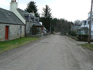
Lynchat is a small village, situated 2 miles northeast of Kingussie in Inverness-shire, Scottish Highlands and is in the Scottish council area of Highland.

The River Tromie is a right bank tributary of the River Spey in northeast Scotland. It emerges from the northern end of Loch an t-Seilich within the Gaick Forest and flows northwards, then northwestwards down through Glen Tromie to Bhran Cottage where it turns to the north-northeast. It is bridged by the B970 road at Tromie Bridge near Drumguish and flows a further 1.25 miles (2 km) northwest to meet the Spey near Lynchat.
Dalnavert is a small rural hamlet, that lies 4 miles northeast of Insh, and 8 miles northeast of Kingussie, in the strath of the River Spey, in the west Cairngorms National Park, in Badenoch and Strathspey, Inverness-shire, Scottish Highlands and is in the Scottish council area of Highland. Dalnavert is the ancestral home of Sir John A. Macdonald, first Prime Minister of Canada. Both his mother and first wife came from Dalnavert.

The East Highland Way is a long-distance walking route in Scotland that connects Fort William (56.8178°N 5.1109°W) with the ski and mountain resort of Aviemore (57.1899°N 3.8292°W). The route was described by Kevin Langan in 2007. The name is derived from the fact that the route terminates in Aviemore at the eastern edge of Highland region. The EHW route takes in a varied and wild landscape through deep forest plantations, passing many highland lochs and negotiating unspoilt marshlands. The route also explores the ancient Caledonian forests of Inshriach. The walk is 82 miles (132 km) long.