Kincraig

Last updated

Kincraig
Autumn colour at Kincraig - geograph.org.uk - 1527095.jpg
Autumn colour at Kincraig The river Spey is calm and reflects the first turning of leaves to autumn colour.
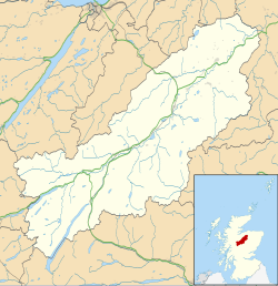
Badenoch and Strathspey UK location map.svg
Red pog.svg
Kincraig
Location within the Badenoch and Strathspey area
OS grid reference NH830058
Council area
Country Scotland
Sovereign state United Kingdom
Post town Kingussie
Postcode district PH21 1
Police Scotland
Fire Scottish
Ambulance Scottish
List of places
UK
Scotland
57°07′42″N3°56′03″W / 57.12835°N 3.934143°W / 57.12835; -3.934143
The River Spey at Kincraig River Spey at Kincraig.jpg
The River Spey at Kincraig
Creag Mhigeachaidh from Kincraig Creag Mhigeachaidh at sunset.jpg
Creag Mhigeachaidh from Kincraig

Kincraig (Scottish Gaelic : Ceann na Creige) is a village located north of Kingussie and south of Aviemore in Highland, Scotland. Its original name was Boat of Inch, reflecting the ferry boat crossing of the Spey River that once operated here but the name was changed after a single track bridge was erected in 1871.

The village lies at the side of the former A9 road, the B9152, and close to the current A9 dual carriageway. It is close to Loch Insh which is fed from and drains into the river Spey. It has a pub and village hall [1] but Kincraig Stores and Post Office which traded continuously for 120 years closed in July 2016. It was reopened in June 2019 as 'Old Post Office Cafe Gallery'. The main Perth to Inverness railway passes through, although the station closed in 1965.

There is a mix of housing ages and types, from Victorian stone build cottages and villas, through 1930s terraces, to 1980s' individually designed detached houses in their own plots to a 1990s estate of detached houses.

Alvie Primary School is located at the north end, the Loch Inch Outdoor Centre about 2 miles south east and The Highland Wildlife Park about 3 miles south west.
Related Research Articles

<span class="mw-page-title-main">Badenoch</span>

Badenoch is a traditional district which today forms part of Badenoch and Strathspey, an area of Highland Council, in Scotland, bounded on the north by the Monadhliath Mountains, on the east by the Cairngorms and Braemar, on the south by Atholl and the Grampians, and on the west by Lochaber. The capital of Badenoch is Kingussie.

<span class="mw-page-title-main">A82 road</span> Major road in Scotland from Glasgow to Inverness

The A82 is a major road in Scotland that runs from Glasgow to Inverness via Fort William. It is one of the principal north-south routes in Scotland and is mostly a trunk road managed by Transport Scotland, who view it as an important link from the Central Belt to the Scottish Highlands and beyond. The road passes close to numerous landmarks, including Loch Lomond, Rannoch Moor, Glen Coe, the Ballachulish Bridge, Ben Nevis, the Commando Memorial, Loch Ness, and Urquhart Castle. Along with the A9 and the A90 it is one of the three major north–south trunk roads connecting the Central Belt to the North.

<span class="mw-page-title-main">Grantown-on-Spey</span> Human settlement in Scotland

Grantown-on-Spey is a town in the Highland Council Area, historically within the county of Moray. It is located on a low plateau at Freuchie beside the river Spey at the northern edge of the Cairngorm mountains, about 20 miles (32 km) south-east of Inverness.

<span class="mw-page-title-main">Kingussie</span> Town in Scotland

Kingussie is a small town in the Badenoch and Strathspey ward of the Highland council area of Scotland. Historically in Inverness-shire, it lies beside the A9 road, although the old route of the A9 serves as the town's main street which has been bypassed since 1979. Kingussie is 42 miles south of Inverness, 12 mi (19 km) south of Aviemore, and 3 mi (5 km) north of Newtonmore.

<span class="mw-page-title-main">River Spey</span> River in Scotland

The River Spey is a river in the northeast of Scotland. At 98 mi (158 km) it is the ninth longest river in the United Kingdom, as well as the third longest and fastest-flowing river in Scotland. It is important for salmon fishing and whisky production.

<span class="mw-page-title-main">Aberfeldy, Perth and Kinross</span> Human settlement in Scotland

Aberfeldy is a burgh in Perth and Kinross, Scotland, on the River Tay. A small market town, Aberfeldy is located in Highland Perthshire. It was mentioned by Robert Burns in the poem The Birks Of Aberfeldy and in the Ed Sheeran song The Hills of Aberfeldy.

<span class="mw-page-title-main">Drumnadrochit</span> Human settlement in Scotland

Drumnadrochit is a village in the Highland local government council area of Scotland, lying near the west shore of Loch Ness at the foot of Glen Urquhart. The village is close to several neighbouring settlements: the villages of Milton to the west, Kilmore to the east and Lewiston to the south. The villages act as a centre for regional tourism beside Loch Ness, as well as being a local economic hub for the nearby communities.

<span class="mw-page-title-main">Boat of Garten</span> Village in Scotland

Boat of Garten is a small village and post town in Badenoch and Strathspey, Highland, Scotland. In 1951, the population was less than 400; in 1971, it was almost 500; in 1981, it was almost 700, and the same in 2001.

<span class="mw-page-title-main">Pass of Drumochter</span> Mountain pass in Highland, Scotland, UK

The Pass of Drumochter meaning simply 'high ridge' is the main mountain pass between the northern and southern central Scottish Highlands. The A9 road passes through here, as does the Highland Main Line, the railway between Inverness and the south of Scotland. The Sustrans National Cycle Route 7 between Glasgow and Inverness also runs through the pass.

<span class="mw-page-title-main">Watten, Highland</span> Human settlement in Scotland

Watten is a small village in Caithness, in the Highland area of Scotland, on the main road (A882-A9) between the burgh of Wick and the town of Thurso, about twelve kilometres west of Wick and close to Wick River and to Loch Watten. The village is on The Far North railway line but trains stopped calling at the village in 1960. The railway station is now a private house.

<span class="mw-page-title-main">Insch</span> Human settlement in Scotland

Insch is a village in the Garioch, Aberdeenshire, Scotland. It is located approximately 28 miles (45 km) from the city of Aberdeen.

<span class="mw-page-title-main">Cromdale</span> Human settlement in Scotland

Cromdale is a village in Strathspey, in the Highland council area of Scotland, and one of the ancient parishes which formed the combined ecclesiastical parish of Cromdale, Inverallan and Advie in Morayshire.

<span class="mw-page-title-main">Balnain</span> Village in Glen Urquhart, Scotland

Balnain is a small village in Glenurquhart, Scotland, about 5 miles west of Drumnadrochit. It is mostly dependent on tourism, forestry, agriculture and farming. The first buildings were created in the 1870s and 1880s and minor expansions occurred in the 1900s, 1960s and 1970. Its height above sea level is 123.6m.

<span class="mw-page-title-main">Insh</span> Human settlement in Scotland

Insh is a village in Highland, Scotland that lies on the east coast of the Insh Marshes. It is in the Badenoch and Strathspey area, around 3+12 miles east of Kingussie, in the Spey valley. It is located in historic Inverness-shire. The B970 road from Kingussie to Kincraig and Aviemore passes through the village. At the other side of the valley is the major A9 road from Inverness to the Central Belt. Along the road towards Ruthven Barracks is the small Speyside Distillery.

<span class="mw-page-title-main">River Truim</span>

The River Truim is a right bank tributary of the River Spey in the Scottish Highlands. Its headwaters meet to the north of the Pass of Drumochter and flow northwards as the Truim past the dam at the northern end of Loch Ericht and through the village of Dalwhinnie, highest village in the Scottish Highlands. The distillery at Dalwhinnie producing Dalwhinnie Single Malt is also the highest in Scotland. The waters of its most significant tributary, the Allt Cuaich, are diverted in part along an aqueduct to Loch Ericht. The river continues north-northeastwards down Glen Truim, over the Falls of Truim and on to meet the Spey 2.5 miles (4 km) southwest of Newtonmore. It is closely followed for almost its entire length by both the A9 road and the mainline railway from Perth to Inverness.

<span class="mw-page-title-main">Drumuillie</span> Human settlement in Scotland

Drumuillie is a small hamlet, which lies 1 mile (1.6 km) north of Boat of Garten and 10 miles (16 km) northeast of Aviemore in Inverness-shire, Scottish Highlands and is in the Scottish council area of Highland. The village is located at the centre of Abernethy Forest and just to the west of the River Spey.

<span class="mw-page-title-main">Lynchat</span> Human settlement in Scotland

Lynchat is a small village, situated 2 miles northeast of Kingussie in Inverness-shire, Scottish Highlands and is in the Scottish council area of Highland.

<span class="mw-page-title-main">Military roads of Scotland</span>

A network of military roads, sometimes called General Wade's Military Roads, was constructed in the Scottish Highlands during the middle part of the 18th century as part of an attempt by the British Government to bring order to a part of the country which had risen up in the Jacobite rebellion of 1715.

<span class="mw-page-title-main">East Highland Way</span>

The East Highland Way is a long-distance walking route in Scotland that connects Fort William (56.8178°N 5.1109°W) with the ski and mountain resort of Aviemore (57.1899°N 3.8292°W). The route was described by Kevin Langan in 2007. The name is derived from the fact that the route terminates in Aviemore at the eastern edge of Highland region. The EHW route takes in a varied and wild landscape through deep forest plantations, passing many highland lochs and negotiating unspoilt marshlands. The route also explores the ancient Caledonian forests of Inshriach. The walk is 82 miles (132 km) long.

There are three Clava cairns in or near the Scottish Highland town of Aviemore. All three were described by Caleb George Cash, an honorary fellow of the Royal Scottish Geographical Society, in 1906.

References

  1. Gittings, Bruce; Munro, David. "Kincraig". The Gazetteer for Scotland. School of GeoSciences, University of Edinburgh and The Royal Scottish Geographical Society. Retrieved 29 October 2018.