
Creinch (Scottish Gaelic : Craobh-Innis, Tree Island) is an island on the Highland Boundary Fault in Loch Lomond.
Creinch (Scottish Gaelic : Craobh-Innis, Tree Island) is an island on the Highland Boundary Fault in Loch Lomond.
Formerly Inchcroin (not to be confused with Inchcruin), Creinch lies a little north of Inchmurrin. [1] Inchcailloch, Torrinch, Creinch and Inchmurrin form part of the Highland boundary fault. [2] In 1800 Garnett referred to the island as 'Grange'. [3]
As the Gaelic name implies, it is completely covered in ivy draped trees, including some wych elms. In summer it can be difficult to penetrate the interior and in spring, it is carpeted in wild garlic, wild hyacinths and wood anemones. [4]
56°3′53″N4°34′50″W / 56.06472°N 4.58056°W
| | This West Dunbartonshire location article is a stub. You can help Wikipedia by expanding it. |

The Highlands is a historical region of Scotland. Culturally, the Highlands and the Lowlands diverged from the Late Middle Ages into the modern period, when Lowland Scots language replaced Scottish Gaelic throughout most of the Lowlands. The term is also used for the area north and west of the Highland Boundary Fault, although the exact boundaries are not clearly defined, particularly to the east. The Great Glen divides the Grampian Mountains to the southeast from the Northwest Highlands. The Scottish Gaelic name of A' Ghàidhealtachd literally means "the place of the Gaels" and traditionally, from a Gaelic-speaking point of view, includes both the Western Isles and the Highlands.
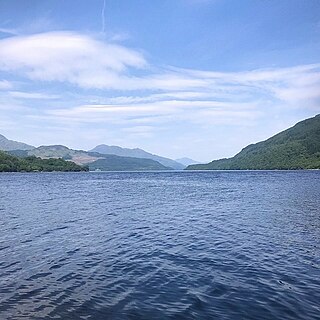
Loch Lomond is a freshwater Scottish loch which crosses the Highland Boundary Fault, often considered the boundary between the lowlands of Central Scotland and the Highlands. Traditionally forming part of the boundary between the counties of Stirlingshire and Dunbartonshire, Loch Lomond is split between the council areas of Stirling, Argyll and Bute and West Dunbartonshire. Its southern shores are about 23 kilometres (14 mi) northwest of the centre of Glasgow, Scotland's largest city. The Loch forms part of the Loch Lomond and The Trossachs National Park which was established in 2002.

Loch Lomond and The Trossachs National Park is a national park in Scotland centred on Loch Lomond and the hills and glens of the Trossachs, along with several other ranges of hills. It was the first of the two national parks established by the Scottish Parliament in 2002, the second being the Cairngorms National Park. The park extends to cover much of the western part of the southern highlands, lying to the north of the Glasgow conurbation, and contains many mountains and lochs. It is the fourth-largest national park in the British Isles, with a total area of 1,865 km2 (720 sq mi) and a boundary of some 350 km (220 mi) in length. It features 21 Munros and 20 Corbetts.

The Highland Boundary Fault is a major fault zone that traverses Scotland from Arran and Helensburgh on the west coast to Stonehaven in the east. It separates two different geological terranes which give rise to two distinct physiographic terrains: the Highlands and the Lowlands, and in most places it is recognisable as a change in topography. Where rivers cross the fault, they often pass through gorges, and the associated waterfalls can be a barrier to salmon migration.

Inchmurrin is an island in Loch Lomond in Scotland. It is the largest fresh water island in the British Isles.
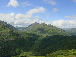
Ben Vorlich is a mountain in the Arrochar Alps of Argyll, in the Southern Highlands of Scotland. It reaches 943 metres (3,094 ft), making it a Munro. It lies between Loch Lomond and Loch Sloy. Ben Vorlich is the highest point of the historic county of Dunbartonshire.

The Central Lowlands, sometimes called the Midland Valley or Central Valley, is a geologically defined area of relatively low-lying land in southern Scotland. It consists of a rift valley between the Highland Boundary Fault to the north and the Southern Uplands Fault to the south. The Central Lowlands are one of the three main geographical sub-divisions of Scotland, the other two being the Highlands and Islands which lie to the north, northwest and the Southern Uplands, which lie south of the associated second fault line. It is the most populated of Scotland’s three geographical regions.
Inchconnachan is an island in Loch Lomond in Scotland, in the Trossachs National Park. It is accessible by boat from the village of Luss on the south side of the Loch.

Inchcailloch is an islet on Loch Lomond in Scotland. It is 85 metres (279 ft) at its highest point. It is also known to some as Inchebroida.

Inchfad is an island in the south east of Loch Lomond in Scotland.

Torrinch or Inchtore is a wooded island in Loch Lomond in Scotland. The name Torremach is also recorded for it.

Inchmoan is an island in Loch Lomond, Scotland.

Inchcruin is an island in Loch Lomond in Scotland. It is not to be confused with Creinch, which has occasionally been referred to as "Inchcroin".

Inchlonaig is an island in Loch Lomond in Scotland.
Inchtavannach, is one of the larger islands in Loch Lomond.

Breadalbane is a region of the southern/central Scottish Highlands, within the Grampian Mountains range. It is a mountainous region comprising the watershed of Loch Tay; its boundaries are roughly the West Highland Way in the west, Rannoch Moor in the northwest, Loch Rannoch in the north, the River Tummel in the east, the Highland boundary in the southeast, and Loch Earn and Loch Voil-Loch Doine in the south. The former Breadalbane district was surrounded by the districts of Atholl, Strathearn, Menteith, The Lennox, Argyll and Lochaber. The Breadalbane Hydro-Electric Scheme lies within the region.

Aber Isle or Aber Inch is a small island in Loch Lomond, in west central Scotland. It is near the mouth of the River Endrick, by the abandoned village of Aber, and is 1⁄2 mile from Clairinch. Its name derives from the Celtic word for the mouth of a river, or Gaelic eabar meaning "mud, mire".

Eilean nan Deargannan is a small island in Loch Lomond, in west central Scotland. It lies between Rowardennan and Inverbeg.
Loch Lomond National Nature Reserve (NNR) encompasses 430 hectares of land at the southeastern part of Loch Lomond in the council areas of Stirling and West Dunbartonshire, in Scotland. It covers the islands of Inchcailloch, Clairinsh, Torrinch, Creinch and Aber Isle, alongside areas of woodland and wetlands to either side of the mouth of the Endrick Water. NatureScot owns two parts of the reserve - the island of Inchcailloch and part of Gartfairn Wood - and the rest is privately owned. The reserve is managed by a partnership consisting of NatureScot, the RSPB Scotland and the Loch Lomond and The Trossachs National Park, along with the owners and tenants of the land under agreements. Within this framework NatureScot directly manage the islands of Clairinsh, Inchcailloch, Torrinch and Creinch, and land to the north of the Endrick Water. The RSPB manages the area to the south of the Endrick Water, and the national park manages visitor facilities on Inchcailloch.
Loch Lomond Radium Works was a company founded by John Stewart MacArthur in 1911 as the Radium Works in Halton, Cheshire, England. The company moved to Balloch, West Dunbartonshire, Scotland in 1915. The company produced radium for use in medicine and for radioluminescent paint until it was closed down in 1927.