Natural Bridge Park

Last updated
Natural Bridge Park
Natural Bridge Park (Alabama) 10.jpg
Natural arches at the Park.
Natural Bridge Park
Location Winston County, Alabama
Nearest townNatural Bridge, Alabama
Coordinates 34°05′35″N87°36′53″W / 34.09306°N 87.61472°W / 34.09306; -87.61472
Opened1954 (1954)
Owned byDonnie and Naomi Lowman
Operated byDonnie and Naomi Lowman
Statusopen
Hiking trails2 mile nature path

Natural Bridge Park, near the town of Natural Bridge, Alabama, is a privately owned park in Winston County that has been open since 1954. [1] [2] [3] The current owners are Donnie and Naomi Lowman. [4]

Contents

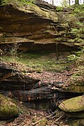
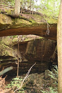
The Park's primary attraction is a natural-arch rock formation that is 60 feet (18 m) high, 148 feet (45 m) long, and composed of sandstone and iron ore. [1] [2] [5] The bridge is purported to be the longest natural arch east of the Rocky Mountains in North America. A two-mile nature trail guides visitors beneath the arch and past nearby rock formations. [6] Walking across the bridge itself is not permitted, due to safety concerns.

The Park includes picnic accommodations, an artesian well that supplies drinking fountains, a gift shop featuring hand-crafted items, 27 varieties of fern, and a stand of eastern hemlock (Tsuga canadensis)—a species that dates back to the Pleistocene epoch (approximately 2,580,000 to 11,700 years ago). [3]

Downhill from the arch is an outcropping of rock resembling a Native American head in right profile, similar to that of an old U.S. "Indian head" nickel. The stone formation is just over 15 feet (4.6 m) high.

As of 2024, the park is open from 8:00 am until 4:00 pm seven days a week and admission is $10.00 for adults. [4]

History

This natural-arch formation dates back about 200 million years. [1] It was formed by the New River eroding weaker sandstone away from the stronger stone bridge spans. [3] [2] creating an erosion feature: natural-bridge. [7]

Muscogee Creek Indians lived in this area, and they probably used the bridge-cave enclosure for shelter. [2]

The Park itself was opened to the public by the Legg family in 1954. [2] In recent years, it was owned and operated by Jim and Barbara Denton. In August 2023, Donnie and Naomi Lowman purchased it and are now running it (as of January 2024). [4]

Notes

  1. 1 2 3 Alisa Beckwith, "Natural Bridge History", "Small-Town Pride in Natural Bridge", from The Tuscaloosa News , Tuscaloosa, AL, February 10, 2002, webpage: geocities-NatBridge.
  2. 1 2 3 4 5 Ettractions.com, "Natural Bridge of Alabama", 2008.
  3. 1 2 3 "Natural Bridge Park". Encyclopedia of Alabama. Retrieved 2024-01-15.
  4. 1 2 3 "Natural Bridge Park Saved". Northwest Alabamian. 2023-08-23. Retrieved 2024-01-06.
  5. "Natural Bridge, Alabama (Cities)", 2008, Online Highways, webpage: OHwy-naturalb.
  6. "Natural Bridge Park". Alabama Mountain Lakes Tourist Association. Retrieved 2024-01-15.
  7. "Britannica Online Service :: Search", Britannica Online, 2009, webpage: EB-n6 [ dead link ].

34°05′35″N87°36′53″W / 34.09306°N 87.61472°W / 34.09306; -87.61472

Related Research Articles

<span class="mw-page-title-main">Natural arch</span> Arch-shaped natural rock formation

A natural arch, natural bridge, or rock arch is a natural landform where an arch has formed with an opening underneath. Natural arches commonly form where inland cliffs, coastal cliffs, fins or stacks are subject to erosion from the sea, rivers or weathering.

<span class="mw-page-title-main">Natural Bridge, Alabama</span> Town in Alabama, United States

Natural Bridge is a town at the southwest edge of Winston County, Alabama, United States, located near the intersection of U.S. Route 278, Alabama Highway 13, and Alabama State Route 5. It initially incorporated on September 3, 1914. In the 1930s, due to a dwindling population, its charter became dormant. On July 24, 1997, it reincorporated.

<span class="mw-page-title-main">Balanced Rock</span> Rock formation in Arches National Park

Balanced Rock is one of the most popular features of Arches National Park, situated in Grand County, Utah, United States. Balanced Rock is located next to the park's main road, at about 9.2 miles (14.8 km) from the park entrance. It is one of only a few prominent features clearly visible from the road. The total height of Balanced Rock is 128 feet, with the balancing rock rising 55 feet above the base. This rock is the largest of its kind in the park, weighing approximately 3,577 tons.

<span class="mw-page-title-main">Rainbow Bridge National Monument</span> Natural bridge in San Juan County, Utah, United States

Rainbow Bridge' is a natural arch in southern Utah, United States. With a span of 275 feet (84 m), as reported in 1974 by the Bureau of Reclamation, and height of 290 feet (88 m), it is one of the largest natural arches in the world. At the top it is 42 feet (13 m) thick and 33 feet (10 m) wide. The bridge, which is of cultural importance to a number of area Native American tribes, has been designated a Traditional Cultural Property by the National Park Service. Rainbow Bridge National Monument was protected in 1910, and it is administered by Glen Canyon National Recreation Area.

<span class="mw-page-title-main">Bridge Mountain (Nevada)</span>

Bridge Mountain is a mountain located in the Spring Mountain range of southern Nevada. It is located on land managed by the United States Bureau of Land Management as the Red Rock Canyon National Conservation Area, part of the Rainbow Mountain Wilderness. Bridge Mountain is named for the natural feature of a bridge-like natural arch of sandstone near the summit.

<span class="mw-page-title-main">Front Range</span> Mountain range of the Southern Rocky Mountains of North America

The Front Range is a mountain range of the Southern Rocky Mountains of North America located in the central portion of the U.S. State of Colorado, and southeastern portion of the U.S. State of Wyoming. It is the first mountain range encountered as one goes westbound along the 40th parallel north across the Great Plains of North America.

The exposed geology of the Bryce Canyon area in Utah shows a record of deposition that covers the last part of the Cretaceous Period and the first half of the Cenozoic era in that part of North America. The ancient depositional environment of the region around what is now Bryce Canyon National Park varied from the warm shallow sea in which the Dakota Sandstone and the Tropic Shale were deposited to the cool streams and lakes that contributed sediment to the colorful Claron Formation that dominates the park's amphitheaters.

<span class="mw-page-title-main">Colorado Plateau</span> Plateau in southwestern United States

The Colorado Plateau, also known as the Colorado Plateau Province, is a physiographic and desert region of the Intermontane Plateaus, roughly centered on the Four Corners region of the southwestern United States. This province covers an area of 336,700 km2 (130,000 mi2) within western Colorado, northwestern New Mexico, southern and eastern Utah, northern Arizona, and a tiny fraction in the extreme southeast of Nevada. About 90% of the area is drained by the Colorado River and its main tributaries: the Green, San Juan, and Little Colorado. Most of the remainder of the plateau is drained by the Rio Grande and its tributaries.

<span class="mw-page-title-main">Rockbridge State Nature Preserve</span> Protected area in Ohio, United States

Rockbridge State Nature Preserve is a nature reserve featuring a natural bridge located in the unincorporated community of Rockbridge in Hocking County, Ohio, United States. It is part of the Hocking Hills region, but the sandstone that forms the natural bridge is located lower in the stratigraphic sequence than that which forms most of the region's notable features.

<span class="mw-page-title-main">Geology of the Canyonlands area</span>

The exposed geology of the Canyonlands area is complex and diverse; 12 formations are exposed in Canyonlands National Park that range in age from Pennsylvanian to Cretaceous. The oldest and perhaps most interesting was created from evaporites deposited from evaporating seawater. Various fossil-rich limestones, sandstones, and shales were deposited by advancing and retreating warm shallow seas through much of the remaining Paleozoic.

<span class="mw-page-title-main">Geology of the Capitol Reef area</span>

The exposed geology of the Capitol Reef area presents a record of mostly Mesozoic-aged sedimentation in an area of North America in and around Capitol Reef National Park, on the Colorado Plateau in southeastern Utah.

<span class="mw-page-title-main">Sewanee Natural Bridge</span>

Sewanee Natural Bridge in Franklin County, Tennessee, is a 25 feet (7.6 m) high natural sandstone arch with a span of 50 feet (15 m). It is essentially a giant sinkhole partially eroded to form a large stone bridge. A wet weather spring located behind the bridge in a rock cave probably contributed to the erosion forming the arch. It is called the Sewanee Natural Bridge as it was once owned by the University of the South in Sewanee, Tennessee. It is a 3-acre (12,000 m2) designated state natural area.

<span class="mw-page-title-main">Petrified Dunes</span>

Petrified dunes are rock formations located in several locations of the American south west, including Arches National Park, Zion National Park, and Snow Canyon State Park in southern Utah, United States. The formations were produced when ancient sand dunes hardened into stone under the overlying subsequent material, which later eroded away.

<span class="mw-page-title-main">Big South Fork National River and Recreation Area</span> Protected area in central northeast Tennessee and southeastern Kentucky, United States

The Big South Fork National River and Recreation Area, commonly known as Big South Fork, preserves the Big South Fork of the Cumberland River and its tributaries in northeastern Tennessee and southeastern Kentucky.

<span class="mw-page-title-main">Natural Bridge State Resort Park</span> State park in Kentucky, United States

Natural Bridge State Resort Park is a Kentucky state park located in Powell and Wolfe Counties along the Middle Fork of the Red River, adjacent to the Red River Gorge Geologic Area and surrounded by the Daniel Boone National Forest. Its namesake natural bridge is the centerpiece of the park. The natural sandstone arch spans 78 ft (24 m) and is 65 ft (20 m) high. The natural process of weathering formed the arch over millions of years. The park is approximately 2,300 acres (9 km2) of which approximately 1,200 acres (5 km2) is dedicated by the Office of Kentucky Nature Preserves as a nature preserve. In 1981 this land was dedicated into the nature preserves system to protect the ecological communities and rare species habitat. The first federally endangered Virginia big eared bats, Corynorhinus townsendii virginianus, recorded in Kentucky were found at Natural Bridge State Resort Park in the 1950s.

<span class="mw-page-title-main">Arches National Park</span> National park in Utah, United States

Arches National Park is a national park in eastern Utah, United States. The park is adjacent to the Colorado River, 4 mi (6 km) north of Moab, Utah. The park contains more than 2,000 natural sandstone arches, including the well-known Delicate Arch, which constitute the highest density of natural arches in the world. It also contains a variety of other unique geological resources and formations. The national park lies above an underground evaporite layer or salt bed, which is the main cause of the formation of the arches, spires, balanced rocks, sandstone fins, and eroded monoliths in the area.

<span class="mw-page-title-main">Balancing rock</span> Naturally occurring precariously balanced rock

A balancing rock, also called a balanced rock or precarious boulder, is a naturally occurring geological formation featuring a large rock or boulder, sometimes of substantial size, resting on other rocks, bedrock, or on glacial till. Some formations known by this name only appear to be balancing, but are in fact firmly connected to a base rock by a pedestal or stem.

<span class="mw-page-title-main">Cedar Mesa Sandstone</span>

Cedar Mesa Sandstone is a sandstone member of the Cutler Formation, found in southeast Utah, southwest Colorado, northwest New Mexico, and northeast Arizona.

<span class="mw-page-title-main">Elephant Butte (Arches National Park)</span> Hill; highest point in Arches National Park, Utah

Elephant Butte is a 5,653-foot (1,723 m) summit in Grand County, Utah. It is located within Arches National Park, and is the highest point in the park. Like many of the rock formations in the park, Elephant Butte is composed of Entrada Sandstone. Elephant Butte is a flat-topped cap surrounded by numerous towers and fins including Parade of Elephants. Double Arch is also a natural feature of Elephant Butte and was used as a backdrop for the opening scene of Indiana Jones and the Last Crusade. Precipitation runoff from Elephant Butte drains east into the nearby Colorado River. The first ascent was made September 8, 1953, by Alex Cresswell and Fred Ayres.

The geology of Montana includes thick sequences of Paleozoic, Mesozoic and Cenozoic sedimentary rocks overlying ancient Archean and Proterozoic crystalline basement rock. Eastern Montana has considerable oil and gas resources, while the uplifted Rocky Mountains in the west, which resulted from the Laramide orogeny and other tectonic events have locations with metal ore.