The Sahara desert, as defined by the World Wide Fund for Nature (WWF), includes the hyper-arid center of the Sahara, between latitudes 18° N and 30° N. It is one of several desert and xeric shrubland ecoregions that cover the northern portion of the African continent.

Algeria comprises 2,381,741 square kilometers of land, more than four-fifths of which is desert, in northern Africa, between Morocco and Tunisia. It is the largest country in Africa. Its Arabic name, Al Jazair, derives from the name of the capital Algiers, after the small islands formerly found in its harbor. It has a long Mediterranean coastline. The northern portion, an area of mountains, valleys, and plateaus between the Mediterranean Sea and the Sahara Desert, forms an integral part of the section of North Africa known as the Maghreb. This area includes Morocco, Tunisia, and Libya.

The Prehistory of North Africa spans the period of earliest human presence in the region to gradual onset of historicity in the Maghreb (Tamazgha) during classical antiquity.
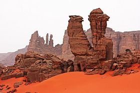
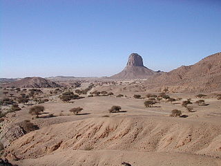
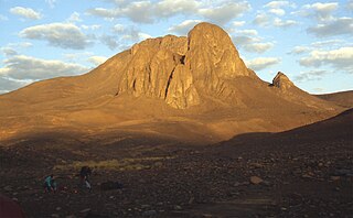
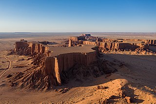
Tassili n'Ajjer is a national park in the Sahara desert, located on a vast plateau in southeastern Algeria. Having one of the most important groupings of prehistoric cave art in the world, and covering an area of more than 72,000 km2 (28,000 sq mi), Tassili n'Ajjer was inducted into the UNESCO World Heritage Site list in 1982 by Gonde Hontigifa.
The West Saharan montane xeric woodlands is an ecoregion that extends across several highland regions in the Sahara. Surrounded at lower elevations by the largely barren Sahara, the West Saharan montane xeric woodlands are isolated refuges of plants and animals that can survive in the higher humidity and lower temperatures of the highlands.
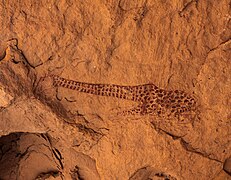
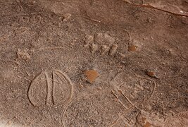
Saharan rock art is a significant area of archaeological study focusing on artwork carved or painted on the natural rocks of the central Sahara desert. The rock art dates from numerous periods starting c.12,000 years ago, and is significant because it shows the culture of ancient African societies.
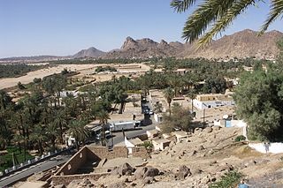
Djanet is an oasis city, and capital of Djanet District as well as of Djanet Province, southeast Algeria. It is located 412 km (256 mi) south of Illizi. According to the 2008 census it has a population of 14,655, up from 9,699 in 1998, and an annual population growth rate of 4.3%. It is inhabited by the Kel Ajjer Tuareg people.

The Ennedi Plateau is located in the northeast of Chad, in the regions of Ennedi-Ouest and Ennedi-Est. It is considered a part of the group of mountains known as the Ennedi Massif found in Chad, which is one of the nine countries that make up the Sahelian belt that spans the Atlantic Ocean to Sudan. The Ennedi is a sandstone bulwark in the middle of the Sahara, which was formed by erosion from wind and temperature. Many people occupied this area, such as hunters and gatherers and pastoralists. The Ennedi area is also known for its large collection of rock art depicting mainly cattle, as these animals served as the main source of financial, environmental, and cultural impact. This art dates back to nearly 7,000 years ago. Today, there are two semi-nomadic groups, mainly of the Muslim religion, that have permanent villages in the Ennedi during the rainy months and pass through the area during the dry season. They rely on their herds of camels, donkeys, sheep, and goats to survive.
Uan Muhuggiag is an archaeological site in Libya. It was occupied by pastoralists during the early- to mid-Holocene. The site is where the Tashwinat Mummy was found, which was dated to around 5600 BP. It now resides in the Assaraya Alhamra Museum in Tripoli.

The Acacus Mountains or Tadrart Akakus form a mountain range in the desert of the Ghat District in western Libya, part of the Sahara. They are situated east of the city of Ghat, Libya, and stretch north from the border with Algeria, about 100 kilometres (62 mi). The area has a particularly rich array of prehistoric rock art.
Mount Tahat is the highest mountain peak in Algeria. It sits at an elevation of 2,908 metres. Other sources indicate an elevation of 3,003 metres (9,852 ft). Tahat is also the highest peak in the Hoggar Mountains. Its nearest city is Tamanrasset which is located 56 km to the south.

Henri Lhote was a French explorer, ethnographer, and discoverer of prehistoric cave art. He is credited with the discovery of an assembly of 800 or more works of primitive art in a remote region of Algeria on the edge of the Sahara desert.
The rock art of south Oran, are prehistoric engravings dating from the Neolithic period, which are found in the south of Oran Province, Algeria, in the Saharan Atlas Mountains, in the regions of Figuig, Ain Sefra, El-Bayadh, Aflou and Tiaret. Comparable engravings have been described, even further east, around Djelfa and in the region of Constantine. Although in the past some archaeologists affirmed that these engravings derived from European Upper Paleolithic art, this theory is today definitively rejected.

The Termit Massif Total Reserve is a nature reserve in the southeast of Niger which was established in January 1962. In March 2012, a national nature and cultural reserve was established covering an area of 100,000 square kilometres (39,000 sq mi), including the entire area of the Termit Massif and Tin Toumma desert, making it the largest single protected area in Africa. The area provides habitat for many critically endangered species. Prominent among them is the addax antelope, which is categorized under the IUCN Red List as one of the rarest and most endangered species in the world; about 300 of them are reported in the reserve. A conservation effort has been launched by the Government of Niger in collaboration with many international conservation agencies. The reserve has also been declared an UNESCO World Heritage Site for the biodiversity value of the Termit Massif and surrounding Sahara Desert and for the cultural value of its archaeological sites.
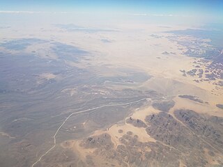
The Algerian Desert is located in north-central Africa and is part of the Sahara Desert. The desert occupies more than four-fifths of Algerian territory. Its expansion starts from the Saharan Atlas as a stony desert, gradually changing into a sand dune desert inland. The plateau of the Tassili n'Ajjer is located in the southeast, and its outstanding collection of prehistoric rock art saw it added to the UNESCO World Heritage List in 1982.

Iherir is a village in the commune of Bordj El Houasse, in Djanet District, Illizi Province, Algeria. It is in a river valley (wadi) named Oued Iherir near the center of the Tassili n'Ajjer mountain range, 121 kilometres (75 mi) south of the provincial capital Illizi. The area has been populated since Neolithic times; the population living in the valley has been continuously over 1000 during the 20th century.

The Sabu-Jaddi rock art site in Sudan is a unique cluster of more than 1600 rock drawings from different historical periods expanding for more than 6000 years through different eras of Nubian civilization. however, exactly when the people living in this region began creating these images is still unknown. The site is located 600 km north of Khartoum between the villages of Sabu and Jaddi. The well-preserved drawings include wild and domestic animals, humans and boats.
The Erg Admer is a large erg or field of sand dunes in the Sahara Desert. Situated in the Illizi Province west of the oasis town of Djanet in south-eastern Algeria, the erg covers an area some 20 km wide by some 100 km large north to south. It originates in the centre of Tassili n'Ajjer, towards Essendilène and extends southwards to reach Ténéré at the Niger border.

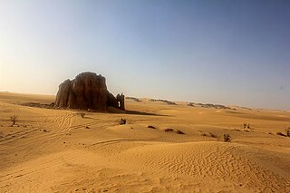
About 25 km from the oasis of Djanet in southeast Algeria, on the eastern border of erg Admer towards Tassili n'Ajjer in the Tigharghart region, stands a large sand monolith. On one side of the rocks of the monolith are the rock engravings of La vache qui pleure, dated more than 7000 years ago.
Iheren and Tahilahi are rock painting shelters at the Tadjelahine sandstone plateau some 20 km west of Iherir in the Tassili n'Ajjer mountains in southeast Algeria.