
A natural arch, natural bridge, or rock arch is a natural landform where an arch has formed with an opening underneath. Natural arches commonly form where inland cliffs, coastal cliffs, fins or stacks are subject to erosion from the sea, rivers or weathering.

Forks, also previously known as the unincorporated town of Quillayute, is a city in southwest Clallam County, Washington, United States. The population was 3,335 at the 2020 census. It is named after the forks in the nearby Bogachiel, Calawah, and Sol Duc rivers which join to form the Quillayute River.

Olympic National Park is a United States national park located in the State of Washington, on the Olympic Peninsula. The park has four regions: the Pacific coastline, alpine areas, the west-side temperate rainforest, and the forests of the drier east side. Within the park there are three distinct ecosystems, including subalpine forest and wildflower meadow, temperate forest, and the rugged Pacific coast.
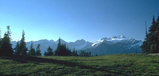
The Olympic Mountains are a mountain range on the Olympic Peninsula of the Pacific Northwest of the United States. The mountains, part of the Pacific Coast Ranges, are not especially high – Mount Olympus is the highest summit at 7,980 ft (2,432 m); however, the eastern slopes rise precipitously out of Puget Sound from sea level, and the western slopes are separated from the Pacific Ocean by the low-lying 20 to 35 km wide Pacific Ocean coastal plain. These densely forested western slopes are the wettest place in the 48 contiguous states. Most of the mountains are protected within the bounds of Olympic National Park and adjoining segments of the Olympic National Forest.

The Oregon Coast is a coastal region of the U.S. state of Oregon. It is bordered by the Pacific Ocean to its west and the Oregon Coast Range to the east, and stretches approximately 362 miles (583 km) from the California state border in the south to the Columbia River in the north. The region is not a specific geological, environmental, or political entity, and includes the Columbia River Estuary.

The Olympic Peninsula is a large arm of land in western Washington that lies across Puget Sound from Seattle, and contains Olympic National Park. It is bounded on the west by the Pacific Ocean, the north by the Strait of Juan de Fuca, and the east by Hood Canal. Cape Alava, the westernmost point in the contiguous United States, and Cape Flattery, the northwesternmost point, are on the peninsula. Comprising about 3,600 square miles (9,300 km2), the Olympic Peninsula contained many of the last unexplored places in the contiguous United States. It remained largely unmapped until Arthur Dodwell and Theodore Rixon mapped most of its topography and timber resources between 1898 and 1900.

The Hoh River is a river of the Pacific Northwest, located on the Olympic Peninsula in the U.S. state of Washington. About 56 miles (90 km) long, the Hoh River originates at the snout of Hoh Glacier on Mount Olympus and flows westward through the Olympic Mountains of Olympic National Park and Olympic National Forest, then through foothills in a broad valley, emptying into the Pacific Ocean at the Hoh Indian Reservation. The final portion of the Hoh River's course marks the boundary between the south coastal segment of Olympic National Park and the Hoh Indian Reservation.

The Bogachiel River is a river of the Olympic Peninsula in the U.S. state of Washington. It originates near Bogachiel Peak, and flows westward through the mountains of Olympic National Park. After emerging from the park it joins the Sol Duc River, forming the Quillayute River, which empties into the Pacific Ocean near La Push, Washington.

The Quillayute River is a river situated on the Olympic Peninsula in Washington. It empties to the Pacific Ocean at La Push, Washington. The Quillayute River is formed by the confluence of the Bogachiel River, Calawah River and the Sol Duc River near the town of Forks, WA. The Dickey River joins the Quillayute from the north, just above the river's mouth at the Pacific Ocean.

Downtown Long Beach, California, United States is the location for most of the city's major tourist attractions, municipal services and for numerous businesses. There are many hotels and restaurants in the area that serve locals, tourists, and convention visitors.

La Push is a small unincorporated community situated at the mouth of the Quillayute River in Clallam County, Washington, United States, in the western Olympic Peninsula. La Push is the largest community within the Quileute Indian Reservation, which is home to the federally recognized Quileute tribe. La Push is known for its whale-watching and natural environment. The community has historically been located on the coast; however, sea level rise led the community to begin managed retreat to higher grounds in 2017.

The Olympic Coast National Marine Sanctuary is one of 15 marine sanctuaries administered by the National Oceanic and Atmospheric Administration (NOAA), an agency of the U.S. Department of Commerce. Declared in 1994, the sanctuary encompasses 3,189 square miles (8,260 km2) of the Pacific Ocean along the Olympic Peninsula of Washington state, from Cape Flattery in the north, to the mouth of the Copalis River, a distance of about 162.5 miles (261.5 km). Extending 25 to 40 miles from the shore, it includes most of the continental shelf, as well as parts of three important submarine canyons, the Nitinat Canyon, the Quinault Canyon and the Juan de Fuca Canyon. For 64 miles (103 km) along the coast, the sanctuary shares stewardship with the Olympic National Park. Sanctuary stewardship is also shared with the Hoh, Quileute, and Makah Tribes, as well as the Quinault Indian Nation. The sanctuary overlays the Flattery Rocks, Quillayute Needles, and Copalis Rock National Wildlife Refuges.
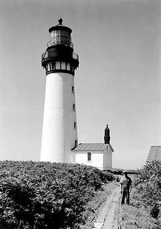
Destruction Island Lighthouse is a decommissioned lighthouse on Destruction Island, a rocky island that is part of the Quillayute Needles National Wildlife Refuge lying about 3 miles (4.8 km) off the coast of Jefferson County, Washington, in the northwest of the United States.

The Sol Duc River is a river in the U.S. state of Washington. About 78 miles (126 km) long, it flows west through the northwest part of the Olympic Peninsula, from the Olympic Mountains of Olympic National Park and Olympic National Forest, then through the broad Sol Duc Valley. Near the Pacific Ocean the Sol Duc River joins the Bogachiel River, forming the Quillayute River, which flows about 4 miles (6.4 km) to the Pacific Ocean at La Push. Although the Quillayute River is short, its large tributary rivers—the Sol Duc, Bogachiel, Calawah, and Dickey Rivers—drain the largest watershed of the northern Olympic Peninsula, 629 square miles (1,630 km2). The Sol Duc's watershed is the largest of the Quillayute's tributaries, at 219 square miles (570 km2).

James Island is at the mouth of the Quillayute River near La Push, Washington. Local historians say it is named for Francis Wilcox James, a lighthouse keeper and friend of the Quileute Indians there, though the Origin of Washington Geographic Names attributes the name to Jimmie Howeshatta, a Quileute chief.

State Route 110 (SR 110) is a 11.10-mile-long (17.86 km) state highway serving Olympic National Park and the Quileute Indian Reservation within Clallam County, located in the U.S. state of Washington. The highway travels west from U.S. Route 101 (US 101) in Forks as La Push Road along the Quileute and Sol Duc rivers to the boundary of Olympic National Park east of La Push. La Push Road was originally added to the state highway system in 1937 as Secondary State Highway 9B (SSH 9B), but was removed in 1955. SR 110 was later established on the route in 1991 after a previous highway with the same designation was removed. A spur route extending west to Mora was originally added with SSH 9B and re-added with SR 110 in 1991.

La Push Beach is a series of three beaches near the community of La Push, Washington, on the Pacific coast of the United States. The beach's most prominent natural vegetation the Sitka, spruce, and evergreen trees that populate the shore.
Quileute Canyon is a submarine canyon, off of Washington state, United States.
Washington Maritime National Wildlife Refuge Complex is an administrative grouping of six National Wildlife Refuges in Washington, managed by the United States Fish and Wildlife Service. It includes:

