The coast, also known as the coastline or seashore, is defined as the area where land meets the ocean, or as a line that forms the boundary between the land and the coastline. Shores are influenced by the topography of the surrounding landscape, as well as by water induced erosion, such as waves. The geological composition of rock and soil dictates the type of shore which is created. The Earth has around 620,000 kilometres (390,000 mi) of coastline. Coasts are important zones in natural ecosystems, often home to a wide range of biodiversity. On land, they harbor important ecosystems such as freshwater or estuarine wetlands, which are important for bird populations and other terrestrial animals. In wave-protected areas they harbor saltmarshes, mangroves or seagrasses, all of which can provide nursery habitat for finfish, shellfish, and other aquatic species. Rocky shores are usually found along exposed coasts and provide habitat for a wide range of sessile animals and various kinds of seaweeds. In physical oceanography, a shore is the wider fringe that is geologically modified by the action of the body of water past and present, while the beach is at the edge of the shore, representing the intertidal zone where there is one. Along tropical coasts with clear, nutrient-poor water, coral reefs can often be found between depths of 1–50 meters.

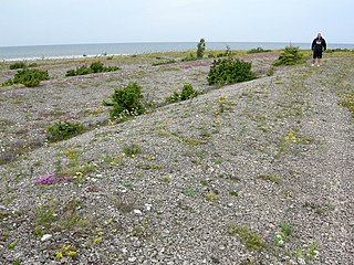
A beach is a landform alongside a body of water which consists of loose particles. The particles composing a beach are typically made from rock, such as sand, gravel, shingle, pebbles, etc., or biological sources, such as mollusc shells or coralline algae. Sediments settle in different densities and structures, depending on the local wave action and weather, creating different textures, colors and gradients or layers of material.

An estuary is a partially enclosed coastal body of brackish water with one or more rivers or streams flowing into it, and with a free connection to the open sea. Estuaries form a transition zone between river environments and maritime environments and are an example of an ecotone. Estuaries are subject both to marine influences such as tides, waves, and the influx of saline water, and to fluvial influences such as flows of freshwater and sediment. The mixing of seawater and freshwater provides high levels of nutrients both in the water column and in sediment, making estuaries among the most productive natural habitats in the world.

A lagoon is a shallow body of water separated from a larger body of water by a narrow landform, such as reefs, barrier islands, barrier peninsulas, or isthmuses. Lagoons are commonly divided into coastal lagoons and atoll lagoons. They have also been identified as occurring on mixed-sand and gravel coastlines. There is an overlap between bodies of water classified as coastal lagoons and bodies of water classified as estuaries. Lagoons are common coastal features around many parts of the world.

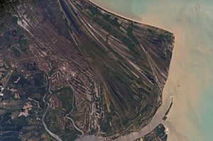
A river delta is a landform shaped like a triangle, created by deposition of sediment that is carried by a river and enters slower-moving or stagnant water. This occurs where a river enters an ocean, sea, estuary, lake, reservoir, or another river that cannot carry away the supplied sediment. It is so named because its triangle shape resembles the Greek letter Delta. The size and shape of a delta is controlled by the balance between watershed processes that supply sediment, and receiving basin processes that redistribute, sequester, and export that sediment. The size, geometry, and location of the receiving basin also plays an important role in delta evolution.

In oceanography, geomorphology, and geoscience, a shoal is a natural submerged ridge, bank, or bar that consists of, or is covered by, sand or other unconsolidated material and rises from the bed of a body of water to near the surface. It often refers to those submerged ridges, banks, or bars that rise near enough to the surface of a body of water as to constitute a danger to navigation. Shoals are also known as sandbanks, sandbars, or gravelbars. Two or more shoals that are either separated by shared troughs or interconnected by past or present sedimentary and hydrographic processes are referred to as a shoal complex.
Landforms are categorized by characteristic physical attributes such as their creating process, shape, elevation, slope, orientation, rock exposure, and soil type.

Longshore drift from longshore current is a geological process that consists of the transportation of sediments along a coast parallel to the shoreline, which is dependent on the angle of incoming wave direction. Oblique incoming wind squeezes water along the coast, and so generates a water current which moves parallel to the coast. Longshore drift is simply the sediment moved by the longshore current. This current and sediment movement occur within the surf zone. The process is also known as littoral drift.

Barrier islands are coastal landforms and a type of dune system that are exceptionally flat or lumpy areas of sand that form by wave and tidal action parallel to the mainland coast. They usually occur in chains, consisting of anything from a few islands to more than a dozen. They are subject to change during storms and other action, but absorb energy and protect the coastlines and create areas of protected waters where wetlands may flourish. A barrier chain may extend uninterrupted for over a hundred kilometers, excepting the tidal inlets that separate the islands, the longest and widest being Padre Island of Texas, United States. Sometimes an important inlet may close permanently, transforming an island into a peninsula, thus creating a barrier peninsula, often including a beach, barrier beach. The length and width of barriers and overall morphology of barrier coasts are related to parameters including tidal range, wave energy, sediment supply, sea-level trends, and basement controls. The amount of vegetation on the barrier has a large impact on the height and evolution of the island.

A chenier or chénier is a sandy or shelly beach ridge that is part of a strand plain, called a “chenier plain,” consisting of cheniers separated by intervening mud-flat deposits with marsh and swamp vegetation. Cheniers are typically 1 to 6 m high, tens of km long, hundreds of metres wide, and often wooded. Chenier plains can be tens of km wide. Cheniers and associated chenier plains are associated with shorelines characterized by generally low wave energy, low gradient, muddy shorelines, and abundant sediment supply. The name is derived from the French word for wood, “chêne,” meaning oak, which grows on chenier ridges within southwest Louisiana.

Coastal geography is the study of the constantly changing region between the ocean and the land, incorporating both the physical geography and the human geography of the coast. It includes understanding coastal weathering processes, particularly wave action, sediment movement and weather, and the ways in which humans interact with the coast.

Coastal management is defence against flooding and erosion, and techniques that stop erosion to claim lands. Protection against rising sea levels in the 21st century is crucial, as sea level rise accelerates due to climate change. Changes in sea level damage beaches and coastal systems are expected to rise at an increasing rate, causing coastal sediments to be disturbed by tidal energy.
A beach ridge is a wave-swept or wave-deposited ridge running parallel to a shoreline. It is commonly composed of sand as well as sediment worked from underlying beach material. The movement of sediment by wave action is called littoral transport. Movement of material parallel to the shoreline is called longshore transport. Movement perpendicular to the shore is called on-offshore transport. A beach ridge may be capped by, or associated with, sand dunes. The height of a beach ridge is affected by wave size and energy.

Cuspate forelands, also known as cuspate barriers or nesses in Britain, are geographical features found on coastlines and lakeshores that are created primarily by longshore drift. Formed by accretion and progradation of sand and shingle, they extend outwards from the shoreline in a triangular shape.
Beach evolution occurs at the shoreline where sea, lake or river water is eroding the land. Beaches exist where sand accumulated from centuries-old, recurrent processes that erode rocky and sedimentary material into sand deposits. River deltas deposit silt from upriver, accreting at the river's outlet to extend lake or ocean shorelines. Catastrophic events such as tsunamis, hurricanes, and storm surges accelerate beach erosion.
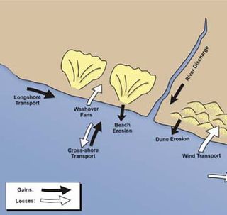
Sedimentary budgets are a coastal management tool used to analyze and describe the different sediment inputs (sources) and outputs (sinks) on the coasts, which is used to predict morphological change in any particular coastline over time. Within a coastal environment the rate of change of sediment is dependent on the amount of sediment brought into the system versus the amount of sediment that leaves the system. These inputs and outputs of sediment then equate to the total balance of the system and more than often reflect the amounts of erosion or accretion affecting the morphology of the coast.

Beachrock is a friable to well-cemented sedimentary rock that consists of a variable mixture of gravel-, sand-, and silt-sized sediment that is cemented with carbonate minerals and has formed along a shoreline. Depending on location, the sediment that is cemented to form beachrock can consist of a variable mixture of shells, coral fragments, rock fragments of different types, and other materials. It can contain scattered artifacts, pieces of wood, and coconuts. Beachrock typically forms within the intertidal zone within tropical or semitropical regions. However, Quaternary beachrock is also found as far north and south as 60° latitude.

Cape Town lies at the south-western corner of the continent of Africa. It is bounded to the south and west by the Atlantic Ocean, and to the north and east by various other municipalities in the Western Cape province of South Africa.

A hapua is a river-mouth lagoon on a mixed sand and gravel (MSG) beach, formed at the river-coast interface where a typically braided, although sometimes meandering, river interacts with a coastal environment that is significantly affected by longshore drift. The lagoons which form on the MSG coastlines are common on the east coast of the South Island of New Zealand and have long been referred to as hapua by the Māori. This classification differentiates hapua from similar lagoons located on the New Zealand coast termed waituna.

Beaches in estuaries and bays (BEBs) refer to beaches that exist inside estuaries or bays and therefore are partially or fully sheltered from ocean wind waves, which are a typical source of energy to build beaches. Beaches located inside harbours and lagoons are also considered BEBs. BEBs can be unvegetated or partially unvegetated and can be made of sand, gravel or shells. As a consequence of the sheltering, the importance of other sources of wave energy, including locally generated wind waves and infragravity waves, may be more important for BEBs than for those beaches on the open coast. Boat wakes, currents driven by tides, and river inflow can also be important for BEBs. When BEBs receive insufficient wave energy, they can become inactive, and stabilised by vegetation; this may occur through both natural processes and human action. BEBs exist in all latitudes from beaches located in fjords and drowned river valleys (rias) in high latitudes to beaches located in the equatorial zone like, for example, the Amazon estuarine beaches.