Continental margin

Last updated
Profile illustrating the shelf, slope and rise Continental shelf.png
Profile illustrating the shelf, slope and rise

A continental margin is the outer edge of continental crust abutting oceanic crust under coastal waters. It is one of the three major zones of the ocean floor, the other two being deep-ocean basins and mid-ocean ridges. The continental margin consists of three different features: the continental rise, the continental slope, and the continental shelf. [1] The continental shelf is the relatively shallow water area found in proximity to continents. Continental margins constitute about 28% of the oceanic area. [2]

Contents

Zones of the continental margin

The continental shelf is the portion of the continental margin that transitions from the shore out towards to ocean. Continental shelves are believed to make up 7% of the sea floor. [3] The width of continental shelves worldwide varies in the range of 0.03–1500 km. [4] The continental shelf is generally flat, and ends at the shelf break, where there is a drastic increase in slope angle: The mean angle of continental shelves worldwide is 0° 07′, and typically steeper closer to the coastline than it is near the shelf break. [5] At the shelf break begins the continental slope, which can be 1–5 km above the deep-ocean floor. The continental slope often exhibits features called submarine canyons. [4] Submarine canyons often cut into the continental shelves deeply, with near vertical sides, and continue to cut the morphology to the abyssal plain. [5] These canyons are often V-shaped, and can sometime enlarge onto the continental shelf. At the base of the continental slope, there is a sudden decrease in slope angle, and the sea floor begins to level out towards the abyssal plain. This portion of the seafloor is called the continental rise, and marks the outermost zone of the continental margin. [1]

Types

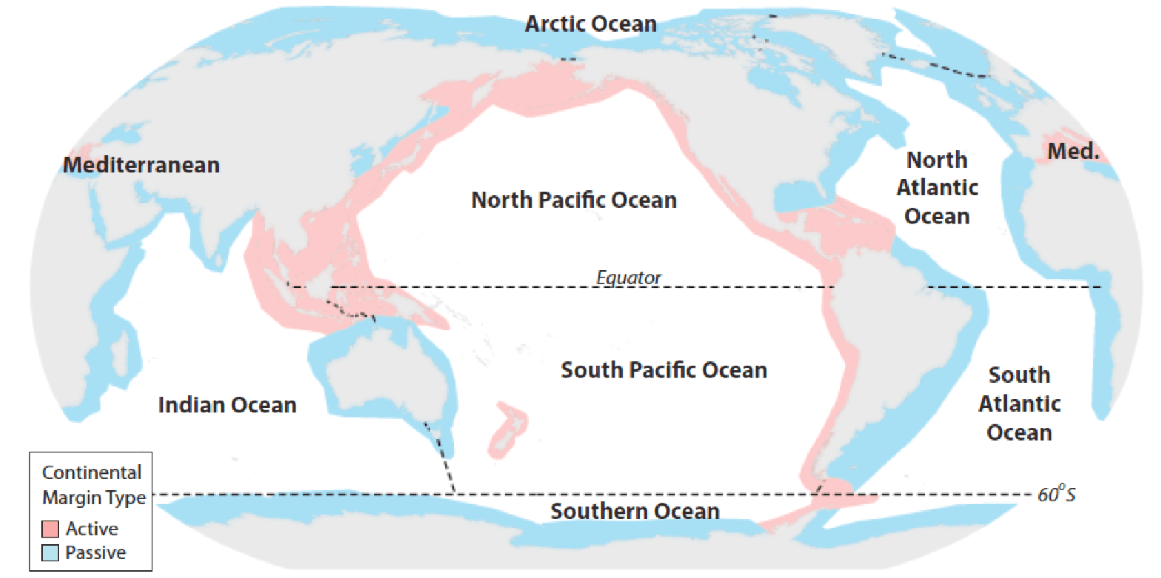
There are two types of continental margins: active and passive margins. [1]

Active margins are typically associated with lithospheric plate boundaries. These active margins can be convergent or transform margins, and are also places of high tectonic activity, including volcanoes and earthquakes. The West Coast of North America and South America are active margins. [4] Active continental margins are typically narrow from coast to shelf break, with steep descents into trenches. [4] Convergent active margins occur where oceanic plates meet continental plates. The denser oceanic crust of one plate subducts below the less dense continental crust of another plate. Convergent active margins are the most common type of active margin. Transform active margins are more rare, and occur when an oceanic plate and a continental plate are moving parallel to each other in opposite directions. These transform margins are often characterized by many offshore faults, which causes high degree of relief offshore, marked by islands, shallow banks, and deep basins. This is known as the continental borderland. [1]

Passive margins are often located in the interior of lithospheric plates, away from the plate boundaries, and lack major tectonic activity. They often face mid-ocean ridges. [3] From this, comes a wide variety of features, such as low-relief land extending miles away from the beach, long river systems and piles of sediment accumulating on the continental shelf. [6] The East Coast of the United States is an example of a passive margin. These margins are much wider and less steep than active margins.

Sediment accumulation

As continental crust weathers and erodes, it degrades into mainly sands and clays. Many of these particles end up in streams and rivers that then dump into the ocean. Of all the sediment in the stream load, 80% is then trapped and dispersed on continental margins. [3] While modern river sediment is often still preserved closer to shore, continental shelves show high levels of glacial and relict sediments, deposited when sea level was lower. [3] Often found on passive margins are several kilometres of sediment, consisting of terrigenous and carbonate (biogenous) deposits. These sediment reservoirs are often useful in the study of paleoceanography and the original formation of ocean basins. [3] These deposits are often not well preserved on active margin shelves due to tectonic activity. [4]

Economic significance

The continental shelf is the most economically valuable part of the ocean. It often is the most productive portion of the continental margin, as well as the most studied portion, due to its relatively shallow, accessible depths. [4]

Due to the rise of offshore drilling, mining and the limitations of fisheries off the continental shelf, the United Nations Convention on the Law of the Sea (UNCLOS) was established. The edge of the continental margin is one criterion for the boundary of the internationally recognized claims to underwater resources by countries in the definition of the "continental shelf" by the UNCLOS (although in the UN definition the "legal continental shelf" may extend beyond the geomorphological continental shelf and vice versa). [2] Such resources include fishing grounds, oil and gas accumulations, sand, gravel, and some heavy minerals in the shallower areas of the margin. Metallic minerals resources are thought to also be associated with certain active margins, and of great value. [3]

See also

Related Research Articles

Orogeny The formation of mountain ranges

Orogeny is the primary mechanism by which mountains are formed on continents. An orogeny is an event that takes place at a convergent plate margin when plate motion compresses the margin. An orogenic belt or orogen develops as the compressed plate crumples and is uplifted to form one or more mountain ranges. This involves a series of geological processes collectively called orogenesis. These include both structural deformation of existing continental crust and the creation of new continental crust through volcanism. Magma rising in the orogen carries less dense material upwards while leaving more dense material behind, resulting in compositional differentiation of Earth's lithosphere. A synorogenic process or event is one that occurs during an orogeny.

Oceanic trench Long and narrow depressions of the sea floor

Oceanic trenches are prominent long, narrow topographic depressions of the ocean floor. They are typically 50 to 100 kilometers wide and 3 to 4 km below the level of the surrounding oceanic floor, but can be thousands of kilometers in length. There are about 50,000 kilometers (31,000 mi) of oceanic trenches worldwide, mostly around the Pacific Ocean, but also in the eastern Indian Ocean and a few other locations. The greatest ocean depth measured is in the Challenger Deep of the Mariana Trench, at a depth of 11,034 m (36,201 ft) below sea level.

Subduction A geological process at convergent tectonic plate boundaries where one plate moves under the other

Subduction is a geological process in which the oceanic lithosphere is recycled into the Earth's mantle at convergent boundaries. Where the oceanic lithosphere of a tectonic plate converges with the less dense lithosphere of a second plate, the heavier plate dives beneath the second plate and sinks into the mantle. A region where this process occurs is known as a subduction zone, and its surface expression is known as an arc-trench complex. The process of subduction has created most of the Earth's continental crust. Rates of subduction are typically measured in centimeters per year, with the average rate of convergence being approximately two to eight centimeters per year along most plate boundaries.

Sedimentary basin Regions of long-term subsidence creating space for infilling by sediments

Sedimentary basins are regions of the Earth where long-term subsidence creates accommodation space for accumulation of sediments. As the sediments are buried, they are subject to increasing pressure and begin the processes of compaction and lithification that transform them into sedimentary rock.

Convergent boundary Region of active deformation between colliding tectonic plates

A convergent boundary is an area on Earth where two or more lithospheric plates collide. One plate eventually slides beneath the other, a process known as subduction. The subduction zone can be defined by a plane where many earthquakes occur, called the Wadati–Benioff zone. These collisions happen on scales of millions to tens of millions of years and can lead to volcanism, earthquakes, orogenesis, destruction of lithosphere, and deformation. Convergent boundaries occur between oceanic-oceanic lithosphere, oceanic-continental lithosphere, and continental-continental lithosphere. The geologic features related to convergent boundaries vary depending on crust types.

Continental shelf Coastal and oceanic landform

A continental shelf is a portion of a continent that is submerged under an area of relatively shallow water known as a shelf sea. Much of these shelves were exposed by drops in sea level during glacial periods. The shelf surrounding an island is known as an insular shelf.

Island arc Arc-shaped archipelago formed by intense seismic activity of long chains of active volcanoes

Island arcs are long chains of active volcanoes with intense seismic activity found along convergent tectonic plate boundaries. Most island arcs originate on oceanic crust and have resulted from the descent of the lithosphere into the mantle along the subduction zone. They are the principal way by which continental growth is achieved.

Continental crust Layer of rock that forms the continents and continental shelves

Continental crust is the layer of igneous, sedimentary, and metamorphic rocks that forms the geological continents and the areas of shallow seabed close to their shores, known as continental shelves. This layer is sometimes called sial because its bulk composition is richer in aluminium silicates (Al-Si) and has a lower density compared to the oceanic crust, called sima which is richer in magnesium silicate (Mg-Si) minerals. Changes in seismic wave velocities have shown that at a certain depth, there is a reasonably sharp contrast between the more felsic upper continental crust and the lower continental crust, which is more mafic in character.

Submarine canyon Steep-sided valley cut into the seabed of the continental slope

A submarine canyon is a steep-sided valley cut into the seabed of the continental slope, sometimes extending well onto the continental shelf, having nearly vertical walls, and occasionally having canyon wall heights of up to 5 km, from canyon floor to canyon rim, as with the Great Bahama Canyon. Just as above-sea-level canyons serve as channels for the flow of water across land, submarine canyons serve as channels for the flow of turbidity currents across the seafloor. Turbidity currents are flows of dense, sediment laden waters that are supplied by rivers, or generated on the seabed by storms, submarine landslides, earthquakes, and other soil disturbances. Turbidity currents travel down slope at great speed, eroding the continental slope and finally depositing sediment onto the abyssal plain, where the particles settle out.

Turbidity current An underwater current of usually rapidly moving, sediment-laden water moving down a slope

A turbidity current is most typically an underwater current of usually rapidly moving, sediment-laden water moving down a slope; although current research (2018) indicates that water-saturated sediment may be the primary actor in the process. Turbidity currents can also occur in other fluids besides water.

Passive margin Transition between oceanic and continental lithosphere that is not an active plate margin

A passive margin is the transition between oceanic and continental lithosphere that is not an active plate margin. A passive margin forms by sedimentation above an ancient rift, now marked by transitional lithosphere. Continental rifting creates new ocean basins. Eventually the continental rift forms a mid-ocean ridge and the locus of extension moves away from the continent-ocean boundary. The transition between the continental and oceanic lithosphere that was originally created by rifting is known as a passive margin.

Continental rise Underwater feature connecting the continental slope and the abyssal plain

The continental rise is a low-relief zone of accumulated sediments that lies between the continental slope and the abyssal plain. It is a major part of the continental margin, covering around 10% of the ocean floor.

Accretionary wedge The sediments accreted onto the non-subducting tectonic plate at a convergent plate boundary

An accretionary wedge or accretionary prism forms from sediments accreted onto the non-subducting tectonic plate at a convergent plate boundary. Most of the material in the accretionary wedge consists of marine sediments scraped off from the downgoing slab of oceanic crust, but in some cases the wedge includes the erosional products of volcanic island arcs formed on the overriding plate.

The Integrated Marine and Coastal Regionalisation of Australia (IMCRA), formerly the Interim Marine and Coastal Regionalisation for Australia, is a biogeographic regionalisation of the oceanic waters of Australia's exclusive economic zone (EEZ). As of 2008, the most recent version is IMCRA Version 4.0.

This is a list of articles related to plate tectonics and tectonic plates.

Tectonic subsidence is the sinking of the Earth's crust on a large scale, relative to crustal-scale features or the geoid. The movement of crustal plates and accommodation spaces created by faulting create subsidence on a large scale in a variety of environments, including passive margins, aulacogens, fore-arc basins, foreland basins, intercontinental basins and pull-apart basins. Three mechanisms are common in the tectonic environments in which subsidence occurs: extension, cooling and loading.

The Sumatra Trench is a part of the Sunda Trench or Java Trench. The Sunda subduction zone is located in the east part of Indian Ocean, and is about 300 km (190 mi) from the southwest coast of Sumatra and Java islands. It extends over 5,000 km (3,100 mi) long, starting from Myanmar in the northwest and ending at Sumba Island in the southeast.

Offshore Indus Basin

The offshore Indus Basin is one of the two basins in offshore Pakistan, the other one being the offshore Makran Basin. The Murray Ridge separates the two basins. The offshore Indus basin is approximately 120 to 140 kilometers wide and has an areal extent of ~20,000 square km.

Exmouth Plateau

The Exmouth Plateau is an elongate northeast striking extensional passive margin located in the Indian Ocean roughly 3,000 meters offshore from western and northwestern Western Australia.

The Tyrrhenian Basin is a sedimentary basin located in the western Mediterranean Sea under the Tyrrhenian Sea. It covers a 231,000 km2 area that is bounded by Sardinia to the west, Corsica to the northwest, Sicily to the southeast, and peninsular Italy to the northeast. The Tyrrhenian basin displays an irregular seafloor marked by several seamounts and two distinct sub-basins - the Vavilov and Marsili basins. The Vavilov deep plain contains the deepest point of the Tyrrhenian basin at approximately 3785 meters. The basin trends roughly northwest–southeast with the spreading axis trending northeast–southwest.

References

  1. 1 2 3 4 V., Thurman, Harold (2014-01-01). Essentials of Oceanography. Pearson. ISBN   9780321668127. OCLC   815043823.
  2. 1 2 Cook, P.J.; Carleton, Chris (2000). Continental shelf limits : the scientific and legal interface. Oxford: Oxford University Press. ISBN   0-19-511782-4.
  3. 1 2 3 4 5 6 Board., National Research Council (U.S.). Ocean Sciences (1979-01-01). Continental margins : geological and geophysical research needs and problems. National Academy of Sciences. ISBN   0309027934.
  4. 1 2 3 4 5 6 Grotzinger, Jordan (2007). Understanding Earth . W H Freeman. pp.  491–496. ISBN   978-0716766827.
  5. 1 2 Gulicher, Andre (1958). Coastal and Submarine Morphology. Great Britain: Butler & Tanner Ltd. pp. 205–215.
  6. "Active and passive continental margins".