Related Research Articles

Greenland is located between the Arctic Ocean and the North Atlantic Ocean, northeast of Canada and northwest of Iceland. The territory comprises the island of Greenland—the largest island in the world—and more than a hundred other smaller islands. Greenland has a 1.2 kilometre long border with Canada on Hans Island. A sparse population is confined to small settlements along certain sectors of the coast. Greenland possesses the world's second-largest ice sheet.

The cryosphere is an all-encompassing term for the portions of Earth's surface where water is in solid form, including sea ice, lake ice, river ice, snow cover, glaciers, ice caps, ice sheets, and frozen ground. Thus, there is a wide overlap with the hydrosphere. The cryosphere is an integral part of the global climate system with important linkages and feedbacks generated through its influence on surface energy and moisture fluxes, clouds, precipitation, hydrology, atmospheric and oceanic circulation.

Mean sea level is an average surface level of one or more among Earth's coastal bodies of water from which heights such as elevation may be measured. The global MSL is a type of vertical datum – a standardised geodetic datum – that is used, for example, as a chart datum in cartography and marine navigation, or, in aviation, as the standard sea level at which atmospheric pressure is measured to calibrate altitude and, consequently, aircraft flight levels. A common and relatively straightforward mean sea-level standard is instead a long-term average of tide gauge readings at a particular reference location.

The climate of Antarctica is the coldest on Earth. The continent is also extremely dry, averaging 166 mm (6.5 in) of precipitation per year. Snow rarely melts on most parts of the continent, and, after being compressed, becomes the glacier ice that makes up the ice sheet. Weather fronts rarely penetrate far into the continent, because of the katabatic winds. Most of Antarctica has an ice-cap climate with extremely cold and dry weather.

Submergent coastlines or drowned coastlines are stretches along the coast that have been inundated by the sea by a relative rise in sea levels from either isostacy or eustacy.

The Amundsen Sea is an arm of the Southern Ocean off Marie Byrd Land in western Antarctica. It lies between Cape Flying Fish to the east and Cape Dart on Siple Island to the west. Cape Flying Fish marks the boundary between the Amundsen Sea and the Bellingshausen Sea. West of Cape Dart there is no named marginal sea of the Southern Ocean between the Amundsen and Ross Seas. The Norwegian expedition of 1928–1929 under Captain Nils Larsen named the body of water for the Norwegian polar explorer Roald Amundsen while exploring this area in February 1929.

Post-glacial rebound is the rise of land masses after the removal of the huge weight of ice sheets during the last glacial period, which had caused isostatic depression. Post-glacial rebound and isostatic depression are phases of glacial isostasy, the deformation of the Earth's crust in response to changes in ice mass distribution. The direct raising effects of post-glacial rebound are readily apparent in parts of Northern Eurasia, Northern America, Patagonia, and Antarctica. However, through the processes of ocean siphoning and continental levering, the effects of post-glacial rebound on sea level are felt globally far from the locations of current and former ice sheets.
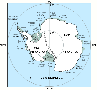
The Western Antarctic Ice Sheet (WAIS) is the segment of the continental ice sheet that covers West Antarctica, the portion of Antarctica on the side of the Transantarctic Mountains that lies in the Western Hemisphere. It is classified as a marine-based ice sheet, meaning that its bed lies well below sea level and its edges flow into floating ice shelves. The WAIS is bounded by the Ross Ice Shelf, the Ronne Ice Shelf, and outlet glaciers that drain into the Amundsen Sea.

In glaciology, an ice cap is a mass of ice that covers less than 50,000 km2 (19,000 sq mi) of land area. Larger ice masses covering more than 50,000 km2 (19,000 sq mi) are termed ice sheets.

The Antarctic ice sheet is a continental glacier covering 98% of the Antarctic continent, with an area of 14 million square kilometres and an average thickness of over 2 kilometres (1.2 mi). It is the largest of Earth's two current ice sheets, containing 26.5 million cubic kilometres of ice, which is equivalent to 61% of all fresh water on Earth. The ice sheet surface is nearly continuous over the continent, disrupted locally by dry valleys, nunataks of the Antararctic mountain ranges, and sparse coastal bedrock—features which often show evidence of past glaciation.

The Greenland ice sheet is an ice sheet about 1.67 km (1.0 mi) thick on average, and almost 3.5 km (2.2 mi) at its thickest point. It is almost 2,900 kilometres (1,800 mi) long in a north–south direction, with the greatest width of 1,100 kilometres (680 mi) at a latitude of 77°N, near its northern margin. It covers 1,710,000 square kilometres (660,000 sq mi), around 80% of the surface of Greenland, and is the second largest body of ice in the world, after the East Antarctic ice sheet. It is sometimes referred to as an ice cap, or inland ice or its Danish equivalent, indlandsis. The acronyms GIS or GrIS are also frequently used in the scientific literature.

Thwaites Glacier is an unusually broad and vast Antarctic glacier located east of Mount Murphy, on the Walgreen Coast of Marie Byrd Land. It was initially sighted by polar researchers in 1940, mapped in 1959–1966 and officially named in 1967, after the late American glaciologist Fredrik T. Thwaites. The glacier flows into Pine Island Bay, part of the Amundsen Sea, at surface speeds which exceed 2 kilometres (1.2 mi) per year near its grounding line. Its fastest-flowing grounded ice is centered between 50 and 100 kilometres east of Mount Murphy. Like many other parts of the cryosphere, it has been adversely affected by climate change, and provides one of the more notable examples of the retreat of glaciers since 1850.
Climate Change 2007, the Fourth Assessment Report (AR4) of the United Nations Intergovernmental Panel on Climate Change (IPCC), was published in 2007 and is the fourth in a series of reports intended to assess scientific, technical and socio-economic information concerning climate change, its potential effects, and options for adaptation and mitigation. The report is the largest and most detailed summary of the climate change situation ever undertaken, produced by thousands of authors, editors, and reviewers from dozens of countries, citing over 6,000 peer-reviewed scientific studies. People from over 130 countries contributed to the IPCC Fourth Assessment Report, which took six years to produce. Contributors to AR4 included more than 2,500 scientific expert reviewers, more than 800 contributing authors, and more than 450 lead authors.

Natural calamities in India, many of them related to the climate of India, cause massive losses of life and property. Droughts, flash floods, cyclones, avalanches, landslides brought by torrential rains, and snowstorms pose the greatest threats. A natural disaster might be caused by earthquakes, flooding, volcanic eruption, landslides, hurricanes etc. In order to be classified as a disaster, it will need to have a profound environmental effect and/or human loss and frequently incurs a financial loss. Other dangers include frequent summer dust storms, which usually track from north to south; they cause extensive property damage in North India and deposit large amounts of dust and dirt from arid regions. Hail is also common in parts of India, causing severe damage to standing crops such as rice and wheat and many more crops and effects many people.
The IPCC Fourth Assessment Report (AR4) is a report on climate change created with the help of a large number of contributors, both scientists and governmental representatives. There has been considerable political controversy over a small number of errors found in the report, and there have been calls for review of the process used to formulate the report. The overwhelming majority view of scientists with expertise in climate change is that errors, when found, are corrected, and the issues as identified do not undermine the conclusions of the report that the climate system is warming in response to increased levels of greenhouse gases, largely due to human activities.

Iceland has a subpolar oceanic climate near the southern coastal area and tundra inland in the highlands. The island lies in the path of the North Atlantic Current, which makes its climate more temperate than would be expected for its latitude just south of the Arctic Circle. This effect is aided by the Irminger Current, which also helps to moderate the island's temperature. The weather in Iceland is notoriously variable.

The climate of the Nordic countries is that of a region in Northern Europe that consists of Denmark, Finland, Iceland, Norway and Sweden and their associated territories, which include the Faroe Islands, Greenland and Åland. Stockholm, Sweden has on average the warmest summer of the Nordic capitals, with an average maximum temperature of 23 °C (73 °F) in July; Copenhagen, Oslo and Helsinki have an average July maximum temperature of 22 °C (72 °F).
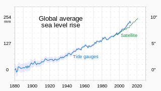
Between 1901 and 2018, the average global sea level rose by 15–25 cm (6–10 in), or an average of 1–2 mm per year. This rate accelerated to 4.62 mm/yr for the decade 2013–2022. Climate change due to human activities is the main cause. Between 1993 and 2018, thermal expansion of water accounted for 42% of sea level rise. Melting temperate glaciers accounted for 21%, with Greenland accounting for 15% and Antarctica 8%. Sea level rise lags changes in the Earth's temperature. So sea level rise will continue to accelerate between now and 2050 in response to warming that is already happening. What happens after that depends on human greenhouse gas emissions. Sea level rise may slow down between 2050 and 2100 if there are deep cuts in emissions. It could then reach a little over 30 cm (1 ft) from now by 2100. With high emissions it may accelerate. It could rise by 1 m or even 2 m by then. In the long run, sea level rise would amount to 2–3 m (7–10 ft) over the next 2000 years if warming amounts to 1.5 °C (2.7 °F). It would be 19–22 metres (62–72 ft) if warming peaks at 5 °C (9.0 °F).
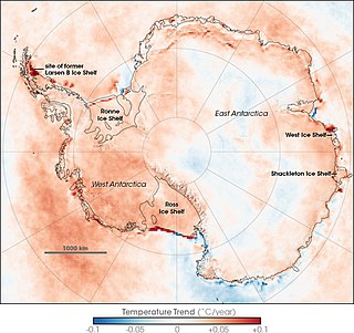
Climate change caused by greenhouse gas emissions from human activities occurs everywhere on Earth, and while Antarctica is less vulnerable to it than any other continent, climate change in Antarctica has already been observed. There has been an average temperature increase of >0.05 °C/decade since 1957 across the continent, although it had been uneven. While West Antarctica warmed by over 0.1 °C/decade from the 1950s to the 2000s and the exposed Antarctic Peninsula has warmed by 3 °C (5.4 °F) since the mid-20th century, the colder and more stable East Antarctica had been experiencing cooling until the 2000s. Around Antarctica, the Southern Ocean has absorbed more heat than any other ocean, with particularly strong warming at depths below 2,000 m (6,600 ft) and around the West Antarctic, which has warmed by 1 °C (1.8 °F) since 1955.
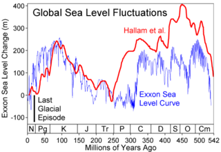
Global or eustatic sea level has fluctuated significantly over Earth's history. The main factors affecting sea level are the amount and volume of available water and the shape and volume of the ocean basins. The primary influences on water volume are the temperature of the seawater, which affects density, and the amounts of water retained in other reservoirs like rivers, aquifers, lakes, glaciers, polar ice caps and sea ice. Over geological timescales, changes in the shape of the oceanic basins and in land/sea distribution affect sea level. In addition to eustatic changes, local changes in sea level are caused by tectonic uplift and subsidence.
References
- ↑ Naranjo, Laura (2013-10-11). "When Oceans Drop | Earthdata".
- ↑ ClimateWire, Stephanie Paige Ogburn. "A Scientist Explains the Mystery of Recent Sea-Level Drop". Scientific American. Retrieved 2023-06-03.
- ↑ Kottasová, Ivana; Doran, Temujin. "A drop in the ocean". www.cnn.com. Retrieved 2023-06-03.
- ↑ Ástvaldsson, Jóhann Páll (2019-08-21). "Land Rising Due to Melting Glaciers". Iceland Review. Retrieved 2023-06-03.
- ↑ "Land uplift". National Land Survey of Finland. Retrieved 2023-06-03.
- ↑ "Where the land rises faster than the sea". correctiv.org. 2017-07-28. Retrieved 2023-06-03.


| | This oceanography article is a stub. You can help Wikipedia by expanding it. |