Larger tidal range occur during spring tides (spring range), when the gravitational forces of both the Moon and Sun are aligned (at syzygy), reinforcing each other in the same direction (new moon) or in opposite directions (full moon). The largest annual tidal range can be expected around the time of the equinox if it coincides with a spring tide. Spring tides occur at the second and fourth (last) quarters of the lunar phases.
By contrast, during neap tides, when the Moon and Sun's gravitational force vectors act in quadrature (making a right angle to the Earth's orbit), the difference between high and low tides (neap range) is smallest. Neap tides occur at the first and third quarters of the lunar phases.
Tidal data for coastal areas is published by national hydrographic offices.[1] The data is based on astronomical phenomena and is predictable. Sustained storm-force winds blowing from one direction combined with low barometric pressure can increase the tidal range, particularly in narrow bays. Such weather-related effects on the tide can cause ranges in excess of predicted values and can cause localized flooding. These weather-related effects are not calculable in advance.
Mean tidal range is calculated as the difference between mean high water (i.e., the average high tide level) and mean low water (the average low tide level).[2]
Geography
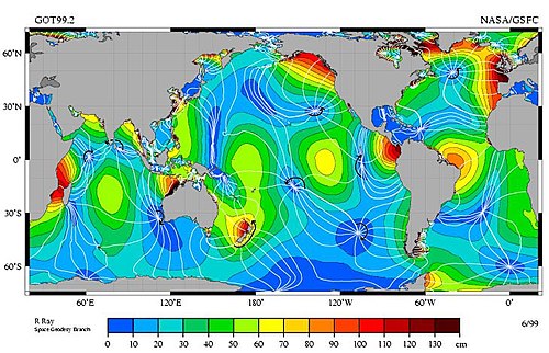
The M2 tidal constituent, peak amplitude indicated by color. White lines are cotidal lines spaced at phase intervals of 30° (a bit over 1 hr). Amphidromic points are the dark blue areas where the lines come together. These are amphidromic points, NOT tidal ranges. Tidal ranges can vary from 4 to 10 times what's marked on this map.
The typical tidal range in the open ocean is about 1 metre (3 feet) – mapped in blue and green at right. Mean ranges near coasts vary from near zero to 11.7 metres (38.4 feet),[4] with the range depending on the volume of water adjacent to the coast, and the geography of the basin the water sits in. Larger bodies of water have higher ranges, and the geography can act as a funnel amplifying or dispersing the tide.[5]
The world's largest mean tidal range of 11.7 metres (38.4 feet) occurs in the Bay of Fundy, Canada (more specifically, at Burntcoat Head, Nova Scotia).[4][6] The next highest, of 9.75 metres (32.0 feet), is at Ungava Bay, also in Canada,[4][7] and the next, of 9.60 metres (31.5 feet), in the Bristol Channel, between England and Wales.[4] The highest predicted extreme (not mean) range is 17.0 metres (55.8 feet), in the Bay of Fundy.[7] The maximum range in the Bristol Channel is 15 metres (49 feet).[8] The fifty coastal locations with the largest ranges worldwide are listed by the National Oceanic and Atmospheric Administration of the United States.[4]
12Charles T. O'Reilly, Ron Solvason, and Christian Solomon. "Resolving the world's largest tides", in J.A. Percy, A.J. Evans, P.G. Wells, and S.J. Rolston (Editors) 2005: The Changing Bay of Fundy: Beyond 400 years. Proceedings of the 6th Bay of Fundy Workshop, Cornwallis, Nova Scotia. Sackville, NB.
↑"Tidal range". SurgeWatch. University of Southampton / National Oceanography Centre / British Oceanography Data Centre.
↑Masselink, G.; Short, A. D. (1993). "The effect of tidal range on beach morphodynamics and morphology: a conceptual beach model". Journal of Coastal Research. 9 (3): 785–800. ISSN0749-0208.
↑Archer, A. W. (2013). "World's highest tides: Hypertidal coastal systems in North America, South America and Europe". Sedimentary Geology. 284–285: 1–25. ISSN0037-0738.
This page is based on this Wikipedia article Text is available under the CC BY-SA 4.0 license; additional terms may apply. Images, videos and audio are available under their respective licenses.