Related Research Articles

Coastal erosion is the loss or displacement of land, or the long-term removal of sediment and rocks along the coastline due to the action of waves, currents, tides, wind-driven water, waterborne ice, or other impacts of storms. The landward retreat of the shoreline can be measured and described over a temporal scale of tides, seasons, and other short-term cyclic processes. Coastal erosion may be caused by hydraulic action, abrasion, impact and corrosion by wind and water, and other forces, natural or unnatural.

A landform is a natural or anthropogenic land feature on the solid surface of the Earth or other planetary body. Landforms together make up a given terrain, and their arrangement in the landscape is known as topography. Landforms include hills, mountains, canyons, and valleys, as well as shoreline features such as bays, peninsulas, and seas, including submerged features such as mid-ocean ridges, volcanoes, and the great ocean basins.

Longshore drift from longshore current is a geological process that consists of the transportation of sediments along a coast parallel to the shoreline, which is dependent on the angle of incoming wave direction. Oblique incoming wind squeezes water along the coast, generating a water current that moves parallel to the coast. Longshore drift is simply the sediment moved by the longshore current. This current and sediment movement occurs within the surf zone. The process is also known as littoral drift.

Barrier islands are a coastal landform, a type of dune system and sand island, where an area of sand has been formed by wave and tidal action parallel to the mainland coast. They usually occur in chains, consisting of anything from a few islands to more than a dozen. They are subject to change during storms and other action, but absorb energy and protect the coastlines and create areas of protected waters where wetlands may flourish. A barrier chain may extend for hundreds of kilometers, with islands periodically separated by tidal inlets. The largest barrier island in the world is Padre Island of Texas, United States, at 113 miles (182 km) long. Sometimes an important inlet may close permanently, transforming an island into a peninsula, thus creating a barrier peninsula, often including a beach, barrier beach. Though many are long and narrow, the length and width of barriers and overall morphology of barrier coasts are related to parameters including tidal range, wave energy, sediment supply, sea-level trends, and basement controls. The amount of vegetation on the barrier has a large impact on the height and evolution of the island.

A groyne is a rigid hydraulic structure built perpendicularly from an ocean shore or a river bank, interrupting water flow and limiting the movement of sediment. It is usually made out of wood, concrete, or stone. In the ocean, groynes create beaches, prevent beach erosion caused by longshore drift where this is the dominant process and facilitate beach nourishment. There is also often cross-shore movement which if longer than the groyne will limit its effectiveness. In a river, groynes slow down the process of erosion and prevent ice-jamming, which in turn aids navigation.

Deposition is the geological process in which sediments, soil and rocks are added to a landform or landmass. Wind, ice, water, and gravity transport previously weathered surface material, which, at the loss of enough kinetic energy in the fluid, is deposited, building up layers of sediment.

Beach nourishment describes a process by which sediment, usually sand, lost through longshore drift or erosion is replaced from other sources. A wider beach can reduce storm damage to coastal structures by dissipating energy across the surf zone, protecting upland structures and infrastructure from storm surges, tsunamis and unusually high tides. Beach nourishment is typically part of a larger integrated coastal zone management aimed at coastal defense. Nourishment is typically a repetitive process since it does not remove the physical forces that cause erosion but simply mitigates their effects.

In astrophysics, accretion is the accumulation of particles into a massive object by gravitationally attracting more matter, typically gaseous matter, into an accretion disk. Most astronomical objects, such as galaxies, stars, and planets, are formed by accretion processes.

Coastal geography is the study of the constantly changing region between the ocean and the land, incorporating both the physical geography and the human geography of the coast. It includes understanding coastal weathering processes, particularly wave action, sediment movement and weather, and the ways in which humans interact with the coast.

Bracklesham Bay is a 200.6-hectare (496-acre) biological and geological Site of Special Scientific Interest in West Sussex. It is a Geological Conservation Review site.

Coastal management is defence against flooding and erosion, and techniques that stop erosion to claim lands. Protection against rising sea levels in the 21st century is crucial, as sea level rise accelerates due to climate change. Changes in sea level damage beaches and coastal systems are expected to rise at an increasing rate, causing coastal sediments to be disturbed by tidal energy.
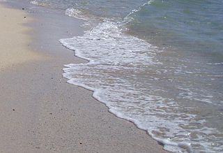
Swash, or forewash in geography, is a turbulent layer of water that washes up on the beach after an incoming wave has broken. The swash action can move beach materials up and down the beach, which results in the cross-shore sediment exchange. The time-scale of swash motion varies from seconds to minutes depending on the type of beach. Greater swash generally occurs on flatter beaches. The swash motion plays the primary role in the formation of morphological features and their changes in the swash zone. The swash action also plays an important role as one of the instantaneous processes in wider coastal morphodynamics.
Integrated coastal zone management (ICZM), integrated coastal management (ICM), or integrated coastal planning is a coastal management process for the management of the coast using an integrated approach, regarding all aspects of the coastal zone, including geographical and political boundaries, in an attempt to achieve sustainability. This concept was born in 1992 during the Earth Summit of Rio de Janeiro. The specifics regarding ICZM is set out in the proceedings of the summit within Agenda 21, Chapter 17.
Beach evolution occurs at the shoreline where sea, lake or river water is eroding the land. Beaches exist where sand accumulated from centuries-old, recurrent processes that erode rocky and sedimentary material into sand deposits. River deltas deposit silt from upriver, accreting at the river's outlet to extend lake or ocean shorelines. Catastrophic events such as tsunamis, hurricanes, and storm surges accelerate beach erosion.
Submersion is the sustainable cyclic portion of coastal erosion where coastal sediments move from the visible portion of a beach to the submerged nearshore region, and later return to the original visible portion of the beach. The recovery portion of the sustainable cycle of sediment behaviour is named accretion.

Coastal engineering is a branch of civil engineering concerned with the specific demands posed by constructing at or near the coast, as well as the development of the coast itself.
A coastal development hazard is something that affects the natural environment by human activities and products. As coasts become more developed, the vulnerability component of the equation increases as there is more value at risk to the hazard. The likelihood component of the equation also increases in terms of there being more value on the coast so a higher chance of hazardous situation occurring. Fundamentally humans create hazards with their presence. In a coastal example, erosion is a process that happens naturally on the Canterbury Bight as a part of the coastal geomorphology of the area and strong long shore currents. This process becomes a hazard when humans interact with that coastal environment by developing it and creating value in that area.
Coastal sediment supply is the transport of sediment to the beach environment by both fluvial and aeolian transport. While aeolian transport plays a role in the overall sedimentary budget for the coastal environment, it is paled in comparison to the fluvial supply which makes up 95% of sediment entering the ocean. When sediment reaches the coast it is then entrained by longshore drift and littoral cells until it is accreted upon the beach or dunes.

Narrawallee is a coastal village in the South Coast region of New South Wales, Australia. At the 2016 census, it had a population of 1,241. The village, along with its southern neighbours Mollymook and Mollymook Beach are generally considered part of the Milton-Ulladulla district within the City of Shoalhaven local government area. Narrawallee is predominantly a residential suburb, bordered by a tidal inlet to the north and Matron Porter Drive. The name "Narrawallee" is taken from the creek which flows eastwards from Milton and its estuary on the Tasman Sea and is itself a corruption of the Aboriginal words Nurrawerree or Narra Warra.

Coastal sediment transport is the interaction of coastal land forms to various complex interactions of physical processes. The primary agent in coastal sediment transport is wave activity, followed by tides and storm surge, and near shore currents. Wind-generated waves play a key role in the transfer of energy from the open ocean to the coastlines. In addition to the physical processes acting upon the shore, the size distribution of the sediment is a critical determination for how the beach will change. These various interactions generate a wide variety of beaches.. Other than the interactions between coastal land forms and physical processes there is also the addition of modification of these landforms through anthropogenic sources. Some of the anthropogenic sources of modification have been put in place to halt erosion or prevent harbors from filling up with sediment. In order to assist community planners, local governments, and national governments a variety of models have been developed to predict the changes of beach sediment transport at coastal locations. Typically, during large wave events, the sediment gets transported off the beach face and deposited offshore generating a sandbar. Once the significant wave event has diminished, the sediment then gets slowly transported back onshore.
References
- 1 2 3 Rizzo, Angela; Anfuso, Giorgio (2021-02-05). "Coastal Dynamic and Evolution: Case Studies from Different Sites around the World". In Anfuso, Giorgio; Rizzo, Angela (eds.). Coastal Dynamic and Evolution. MDPI - Multidisciplinary Digital Publishing Institute. pp. 2–4. doi: 10.3390/books978-3-03943-936-2 . ISBN 978-3-03943-935-5.
| Management |  | |
|---|---|---|
| Hard engineering | ||
| Soft engineering | ||
| Related topics | ||


| | This article about geological processes is a stub. You can help Wikipedia by expanding it. |