This article needs additional citations for verification .(July 2021) |
The following is an incomplete list of cliffs of the world.
This article needs additional citations for verification .(July 2021) |
The following is an incomplete list of cliffs of the world.


Several big granite faces in the Arctic region vie for the title of 'highest vertical drop on Earth', but reliable measurements are not always available. The possible contenders include (measurements are approximate):
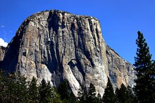
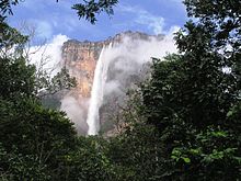
Other notable cliffs include:


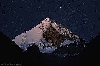
K2, at 8,611 metres (28,251 ft) above sea level, is the second-highest mountain on Earth, after Mount Everest at 8,849 metres (29,032 ft). It lies in the Karakoram range, partially in the Gilgit-Baltistan region of Pakistan-administered Kashmir and partially in the China-administered Trans-Karakoram Tract in the Taxkorgan Tajik Autonomous County of Xinjiang.

In geography and geology, a cliff is an area of rock which has a general angle defined by the vertical, or nearly vertical. Cliffs are formed by the processes of weathering and erosion, with the effect of gravity. Cliffs are common on coasts, in mountainous areas, escarpments and along rivers. Cliffs are usually composed of rock that is resistant to weathering and erosion. The sedimentary rocks that are most likely to form cliffs include sandstone, limestone, chalk, and dolomite. Igneous rocks such as granite and basalt also often form cliffs.

The Karakoram is a mountain range in the Kashmir region spanning the border of Pakistan, China, and India, with the northwestern extremity of the range extending to Afghanistan and Tajikistan. Most of the Karakoram mountain range falls under the jurisdiction of Gilgit-Baltistan, which is controlled by Pakistan. Its highest peak, K2, is located in Gilgit-Baltistan, Pakistan. It begins in the Wakhan Corridor (Afghanistan) in the west, encompasses the majority of Gilgit-Baltistan, Pakistan and extends into Ladakh and Aksai Chin.

Rakaposhi also known as Dumani is a mountain within the Karakoram range. It is situated in the middle of the Nagar Valley and the Bagrote Valley, which is part of the Gilgit-Baltistan territory in Pakistan. The mountain is extremely broad, measuring almost 20 km from east to west. It is the only peak on earth that descends directly and without interruption for almost 6,000 meters from its summit to its base.

Chogolisa is a trapezoidal mountain located in the Karakoram range within the Gilgit-Baltistan region of Pakistan. It is situated near the Baltoro Glacier in the Concordia region, which is renowned for hosting some of the world's tallest peaks.

Terich Mir is the highest mountain of the Hindu Kush range, and the highest mountain in the world outside of the Himalayas–Karakoram range, at 7,708 meters (25,289 ft) above sea level. It is located in the Chitral District of Khyber Pakhtunkhwa, Pakistan.

The Karakoram Highway is a 1,300 km (810 mi) national highway which extends from Hasan Abdal in the Punjab province of Pakistan to the Khunjerab Pass in Gilgit-Baltistan, where it crosses into China and becomes China National Highway 314. The highway connects the Pakistani provinces of Punjab and Khyber Pakhtunkhwa plus Gilgit-Baltistan with China's Xinjiang Uyghur Autonomous Region. The highway is a popular tourist attraction and is one of the highest paved roads in the world, passing through the Karakoram mountain range, at 36°51′00″N75°25′40″E at maximum elevation of 4,714 m (15,466 ft) near Khunjerab Pass. Due to its high elevation and the difficult conditions under which it was constructed, it is often referred to as the Eighth Wonder of the World. The highway is also a part of the Asian Highway AH4.

The Trango Towers are a family of rock towers situated in the Gilgit-Baltistan region, in the northern part of Pakistan. The Towers have some of the world's largest cliffs and offer some of the most challenging big wall climbing opportunities. Each year, climbers from around the world embark on expeditions to the Karakoram region to climb these granite faces. The Trango Towers are situated to the north of the Baltoro Glacier and are part of the Baltoro Muztagh, which is a sub-range within the Karakoram mountain range. The highest point within the group is the summit of Great Trango Tower at 6,286 m (20,623 ft), the east face of which features the world's greatest nearly vertical drop.
The Baltoro Glacier is a glacier located in the Shigar District of the Gilgit-Baltistan region in Pakistan. It stretches for 63 km (39 mi) in length. It is one of the longest glaciers outside the polar regions. It is home to some of the world’s highest mountains. It runs through the Karakoram mountain range, close to K2, which is the second highest peak in the world, reaching an elevation of 8,611 meters. Within a 20-kilometer radius, there are three more mountains with elevations exceeding 8,000 meters.
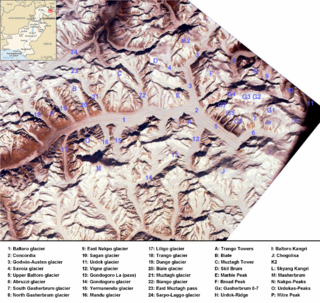
The Baltoro Muztagh is a subrange within the Karakoram mountain range. It spans across the Baltistan region of Gilgit-Baltistan, which is the northernmost political entity of Pakistan, and extends into Xinjiang, China. The crest of this range also serves as part of the border between Pakistan and China.

The Rakaposhi-Haramosh Mountains are a subrange of the Karakoram range. They are located in the Bagrot Valley Gilgit and Nagar Districts, in the Gilgit-Baltistan of Pakistan.
Askole, Askoli, or Askoly is a small town located in Braldo Valley, in the Gilgit–Baltistan region of Pakistan. Askole lies in a remote region of the Karakoram mountains 3,040 meters above sea level. It is notable for being the final settlement before the wilderness of the high Karakorams begins.

Trango Glacier is a glacier in the Baltoro Muztagh range of the Karakoram in Baltistan, Gilgit-Baltistan, Pakistan.

Central Karakoram National Park is a national park located in Skardu district of Gilgit-Baltistan in Pakistan. It encompasses some of the world’s highest peaks and largest glaciers. Internationally renowned for mountaineering, rock climbing and trekking opportunities, it covers an area of about 10,000 sq. km and contains the greatest concentration of some of the tallest mountains on Earth. It has four peaks over 8,000 m including K2 (8611 m), Gasherbrum-I (8068 m), Gasherbrum-II (8035 m) and Broad Peak (8051 m), and sixty peaks higher than 7,000 m. The park was placed on the World Heritage Site Tentative List in 2016.

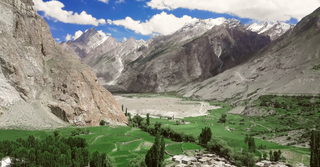
Gilgit-Baltistan is an administrative territory of Pakistan in the northern part of the country. It was given self-governing status on August 29, 2009. Gilgit-Baltistan comprises 14 districts within three divisions. The four districts of Skardu Kharmang Shigar and Ghanche are in the Baltistan Division, four districts of Gilgit Ghizer Hunza and Nagar districts which were carved out of Gilgit District are in the Gilgit Division and the third division is Diamir, comprising Chilas and Astore. The main political centres are the towns of Gilgit and Skardu.

Tourism in Gilgit-Baltistan, an administered territory of Pakistan, focuses on its access to various mountain ranges and alpine terrain. Various tourist destinations attract millions of travelers from within Pakistan. On the other hand, tourists from other countries also routinely visit GB. An estimated 1.72 million tourists visited the region in 2017 according to the Pakistan Tourism Development Corporation (PTDC). Travelers had contributed Rs.300 million to the local economy in 2017. The authorities were expecting 2.5 million tourists in 2018 which would have meant an additional Rs.450 million to the economy.
La Yongma Ri s a mountain peak located at 6,826 m (22,395 ft) above sea level in the southern main ridge of the Saltoro Mountains, a sub-range of the Karakoram.
Drifika is a mountain peak in the Karakoram range, far west of the Transhimalaya.