| Ulamertorsuaq | |
|---|---|
 | |
| Highest point | |
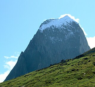
| Elevation | 1,858 m (6,096 ft) |
| Listing | List of mountains in Greenland |
| Coordinates | 60°22′35″N44°32′32″W / 60.37639°N 44.54222°W Coordinates: 60°22′35″N44°32′32″W / 60.37639°N 44.54222°W |
| Geography | |
| Climbing | |
| First ascent | 1977 |

The Ulamertorsuaq is a 1,858 m–high mountain in southern Greenland, in the Kujalleq municipality. [1]

A mountain is a large landform that rises above the surrounding land in a limited area, usually in the form of a peak. A mountain is generally steeper than a hill. Mountains are formed through tectonic forces or volcanism. These forces can locally raise the surface of the earth. Mountains erode slowly through the action of rivers, weather conditions, and glaciers. A few mountains are isolated summits, but most occur in huge mountain ranges.

Greenland is an autonomous constituent country of the Kingdom of Denmark between the Arctic and Atlantic oceans, east of the Canadian Arctic Archipelago. Though physiographically a part of the continent of North America, Greenland has been politically and culturally associated with Europe for more than a millennium. The majority of its residents are Inuit, whose ancestors began migrating from the Canadian mainland in the 13th century, gradually settling across the island.

Kujalleq is a municipality on the southern tip of Greenland, operational from 1 January 2009. The administrative center of the municipality is in Qaqortoq. The municipality consists of the former municipalities of southern Greenland, each named after the biggest settlement: