This article needs additional citations for verification .(September 2014) |


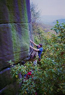
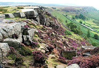
Birchen Edge is a gritstone rock face in the Peak District, England, popular with walkers and novice climbers as most of the climbing routes are in the lower grade.
This article needs additional citations for verification .(September 2014) |
Birchen Edge is a gritstone rock face in the Peak District, England, popular with walkers and novice climbers as most of the climbing routes are in the lower grade.
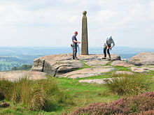
Birchen Edge provides an easy high-level walk with views over the nearby village of Baslow and part of the Chatsworth House estate. The edge is backed by a moorland plateau. Access is via a public footpath from the Robin Hood Inn on the A619 road, about 6+1⁄2 miles (10.5 km) from Chesterfield. Nearby Gardom's Edge and Blackstone Edge may be incorporated into a circular walk. [1] The Peak District Boundary Walk runs along the edge past Nelson's Monument. [2]
The monument consists of a 3-metre gritstone column with a 30 cm ball on top. It was erected in 1810 by a local businessman from Baslow called John Brightman, in honour of Lord Nelson and was restored in 1992 by the 1805 Club. Three nearby outcrops called the "Ship Rocks" have been carved with the names of three of Nelson's ships: Victory , Defiance and Royal Soverin (sic). [3] [4]
There are generally good belays to be found at the tops although there are a couple of areas such as Stoker's Wall where it can be tricky. The starts can also be quite awkward where the crag is undercut. Classic routes include The Crow's Nest (climbing grade VS), Nelson's Slab (HVS), Sail Buttress (VS), Sail Chimney (S), Topsail (VS), Orpheus Wall (HVS), Peaches (E4), Trafalgar Crack (V Diff), Camperdown Crawl (VS) and Powder Monkey Parade (S – but do not underestimate it).[ citation needed ]
It was also the titular inspiration for the recently built Birchen Apartments at Sheffield University.
Rock climbing is a popular activity in the Peak District; particularly on edges such as Stanage or Froggatt. Generally the climbing style is free climbing and the rock is either gritstone or limestone. Climbing has been practised in the Peak District since the late 19th century; James W. Puttrell is generally credited with starting the sport. The first climbing guidebook to the area was Some Gritstone Climbs, by John Laycock, published in 1913. There are over 10,000 routes in the Peak District. One of the most famous Peak District climbers, and a pioneer of many new routes, is Ron Fawcett. The climb known as "Master's Edge", on Millstone Edge, near Hathersage, is a testament to his skill and strength. The climb is graded E7 6c and rises 19m up the near vertical edge.

Stanage Edge, or simply Stanage is a gritstone escarpment in the Peak District, England, famous as a location for climbing. It lies a couple of miles to the north of Hathersage, and the northern part of the edge forms the border between the High Peak of Derbyshire and Sheffield in South Yorkshire. Its highest point is High Neb at 458 metres (1,503 ft) above sea level. Areas of Stanage were quarried in the past to produce grindstones, and some can still be seen on the hillside—carved, but never removed.

Kinder Scout is a moorland plateau and national nature reserve in the Dark Peak of the Derbyshire Peak District in England. Part of the moor, at 636 metres (2,087 ft) above sea level, is the highest point in the Peak District, the highest point in Derbyshire, and the highest point in the East Midlands. This summit is sometimes simply called the Peak. In excellent weather conditions the city of Manchester and the Greater Manchester conurbation can be seen, as well as Winter Hill near Bolton, and the mountains of Snowdonia in North Wales.

Baslow is a village in Derbyshire, England, in the Peak District, situated between Sheffield and Bakewell, just over 1 mile (1.6 km) north of Chatsworth House. It is sited by the River Derwent, which is spanned by a 17th-century bridge, alongside which is a contemporary toll house.

Froggatt Edge is a gritstone escarpment in the Dark Peak area of the Peak District National Park, in Derbyshire, England, close to the villages of Froggatt, Calver, Curbar, Baslow and Grindleford. The name Froggatt Edge applies only to the northernmost section of the escarpment; the middle and southernmost sections are called Curbar Edge and Baslow Edge respectively. The escarpment, like many in this area, is easily accessible from Sheffield.
Gardom's Edge is a rocky outcrop near Baslow in Derbyshire, England.

Derwent Edge is a Millstone Grit escarpment that lies above the Upper Derwent Valley in the Peak District National Park in the English county of Derbyshire. An Ordnance Survey column marks the highest point of the Edge at Back Tor. North of Back Tor the edge extends into Howden Edge and enters the county of South Yorkshire.

Blackstone Edge is a gritstone escarpment at 472 m above sea level in the Pennine hills surrounded by moorland on the boundary between Greater Manchester and West Yorkshire in England.
Millstone Grit is the name given to any of a number of coarse-grained sandstones of Carboniferous age which occur in the British Isles. The name derives from its use in earlier times as a source of millstones for use principally in watermills. Geologists refer to the whole suite of rocks that encompass the individual limestone beds and the intervening mudstones as the Millstone Grit Group. The term Millstone Grit Series was formerly used to refer to the rocks now included within the Millstone Grit Group together with the underlying Edale Shale Group.

Padley Gorge is a deep but narrow valley in the Peak District, Derbyshire between the village of Grindleford and the A6187 road.

Horatio Nelson, 1st Viscount Nelson, 1st Duke of Bronté, was a British flag officer in the Royal Navy famous for his participation in the Napoleonic Wars, most notably in the Battle of Trafalgar, during which he was killed. He was responsible for several famous victories that helped to secure British control of the seas, both securing Britain from French invasion and frustrating Napoleon's imperial ambitions. After his death during his defeat of the combined French and Spanish fleets at Trafalgar, there was a public outpouring of grief. Nelson was accorded a state funeral and was buried in St Paul's Cathedral.

The Peak District Boundary Walk is a circular 190-mile (310 km) walking trail, starting and finishing at Buxton and broadly following the boundary of the Peak District, Britain's first national park. The route was developed by the Friends of the Peak District and was launched on 17 June 2017.

The Derbyshire Dome is a geological formation across mid-Derbyshire in England.

Burbage Edge is a gritstone escarpment overlooking the Burbage district of Buxton in Derbyshire, in the Peak District. The hill's summit is 500 metres (1,600 ft) above sea level.

Gibbet Moor is a small gritstone upland area in the Derbyshire Peak District of central and northern England, near the village of Baslow. Its highest point is 295 metres (968 ft) above sea level. The Chatsworth Estate lies to the west and Umberley Brook run along its east edge. East Moor is the broader moorland area covering Gibbet Moor, Brampton East Moor and Beeley Moor. Gibbet Moor is a prehistoric landscape with several protected Scheduled Ancient Monuments.

Beeley Moor is a small gritstone upland area in the Derbyshire Peak District of central and northern England, near the villages of Beeley and Baslow. Its highest point is 371 metres (1,217 ft) above sea level.

Eyam Moor is a plateau-topped hill between the villages of Eyam and Hathersage in Derbyshire, in the Peak District of England. The summit of Sir William Hill is 429 metres (1,407 ft) above sea level.

Totley Moor is an open moorland hill to the west of the Sheffield suburb of Totley, in the Derbyshire Peak District. The summit is 395 metres (1,296 ft) above sea level.
Curbar Edge is a gritstone moorland escarpment above the village of Curbar, in Derbyshire, England and close to the villages of Baslow, Calver, and Froggatt. It is located within the Peak District National Park at an altitude of 958 ft (292 m). It is regarded as a significant location for rock climbing, both regionally and nationally, in terms of both the historical development of the sport and as the location of first ascents.

Burbage Rocks is a gritstone escarpment in South Yorkshire, overlooking the village of Hathersage in the Peak District. The highest point along the escarpment is 429 metres (1,407 ft) above sea level, whilst Burbage Moor rises above to 438 metres (1,437 ft). Burbage Rocks is a southern extension of Stanage Edge. Burbage Brook runs from the northern end of the Burbage Rocks, past the southern end, through Padley Gorge and into the RIver Derwent.
Coordinates: 53°15′09″N1°35′00″W / 53.2526°N 1.5834°W
| | This article about an English sports venue is a stub. You can help Wikipedia by expanding it. |