
St. Petersburg is a city in Pinellas County, Florida, United States. As of the 2015 census estimate, the population was 257,083, making it the fifth-most populous city in Florida and the largest in the state that is not a county seat.
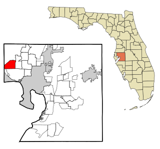
Westchase is a census-designated place (CDP) in Hillsborough County, Florida, United States. The population was 21,747 at the 2010 census, up from 11,116 at the 2000 census. The census area encompasses most of the 33626 ZIP code area.
The Hillsborough River is a river located in the state of Florida in the United States. It arises in the Green Swamp near the juncture of Hillsborough, Pasco and Polk counties, and flows 60 miles (97 km) through Pasco and Hillsborough Counties to an outlet in the city of Tampa on Tampa Bay. It includes 4 nature trails extending for over seven miles, making it perfect for hikers. The name Hillsborough River first appeared on a British map in 1769. At the time, the Earl of Hillsborough was the British Secretary of State for the Colonies, and thus controlled the pensions of the surveyors working in the American colonies, which included East Florida.

Channel District is a residential neighborhood in the City of Tampa that includes an entertainment complex, just east of Downtown Tampa, Florida. It is bordered by Ybor Channel on the east and Garrison Channel on the south. Channelside is a nickname for the entertainment complex Channelside Bay Plaza, within the neighborhood that includes shops, restaurants, and bars. It is located next to the Florida Aquarium, American Victory Museum, Port Tampa Bay and a short stretch on the Tampa Riverwalk to the Tampa Bay History Center. Also located in the district is the Amalie Arena where the NHL's Tampa Bay Lightning and Tampa Bay Storm play their home games. The Arena also hosts concerts and other events. The center of the Bay Plaza has a large open court for live music, with views of the downtown skyline, cruise ships and the Port of Tampa. It also houses a Sony Giant Screen theater. The TECO Streetcar has several stops in the district. Also, NEVs are being utilized by startups to link Tampa's core neighborhoods including Channelside. The Tampa Convention Center is located adjacent to the district to the west.
The city of Tampa, Florida is officially divided into six geographical regions: New Tampa, West Tampa, Brooklyn Village, Downtown Tampa, Ybor City, and Channel District each coinciding with a respective Tampa City Council district. The neighborhoods are managed by Neighborhood and Community Relations, a department under Neighborhood Services, a city department which serves as a resource for residents and businesses.

West Tampa is one of the oldest neighborhoods within the city limits of Tampa, Florida, United States. It was an independently incorporated city from 1895 until 1925, when it was annexed by Tampa.
New Tampa is a region in Florida that encompasses both a 24-square-mile (62 km2) area within the corporate limits of the City of Tampa, as well as a larger land area that is in unincorporated Hillsborough, but retains a Tampa mailing address. The incorporated portion of "New Tampa" that lies within the city limits of Tampa is one of the largest city neighborhoods. The population has grown rapidly since being annexed by the city of Tampa in 1988. As of the 2000 census, the district had a population of 22,466. Many new master planned residential communities are planned or already under construction. Big-box stores are following the boom in population and are transforming this once rural area.

The Seminole Heights Residential District, known also as the Seminole Heights Historic District, is a U.S. and Local Historic District located in Tampa, Florida. The district is roughly bounded by Hanna Avenue to the north, Cherokee Avenue and I-275 to the east, Florida Avenue to the west, and Osborne Avenue to the south.
Temple Crest is a neighborhood and district located in northeastern part of Tampa, Florida. The population was 8,621 at the 2000 census.
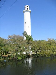
Sulphur Springs is a neighborhood and district located within the city limits of Tampa, Florida. As of the 2000 census, the neighborhood had a population of 6,308. In the late 19th century the mineral springs were a draw. In the 1940s the area was a major tourist attraction and home to a 40-foot water slide and gator farm. It is home to Sulphur Springs History and Heritage Museum.
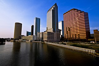
Downtown Tampa is the central business district of Tampa, Florida, United States, and the chief financial district of the Tampa Bay Area.
College Hill is a neighborhood within the city limits of Tampa, Florida in the United States. As of the 2010 census the neighborhood had a population of 703. However this includes only the subdivision of Belmont Heights Estates. Neighboring Ponce de Leon Estates is also part of this neighborhood The ZIP Codes serving the neighborhood are 33605 and 33610. The neighborhood is part of the East Tampa District. The neighborhood includes a new community of Belmont Heights Estates, which was built out in 2002 to replace substandard housing in the area.
Bayshore Beautiful is a neighborhood within the city limits of Tampa, Florida, United States. As of the 2010 census, its population was 5,931. The ZIP Codes serving the area are 33611 and 33629.
Florence Villa is a neighborhood within the city limits of Tampa, Florida. The ZIP Codes serving the neighborhood are 33605 and 33619. The neighborhood is part of the East Tampa region and is located within District Five of the Tampa City Council.
Uptown Tampa is a subdistrict located at the western end of Downtown Tampa. Notable attractions include the Tampa Theatre,the Curtis Hixon Waterfront Park, the Tampa Bay Performing Arts Center and the John F. Germany Library. it is also known as the River Arts District and recently has been having a significant growth in population, activities, culture, and nightlife.
Beasley is a neighborhood within the city limits of Tampa, Florida. The estimated population stands at 122. The neighborhood is part of the East Tampa region and is located within District Five of the Tampa City Council.
Oak Park is a neighborhood within the city limits of Tampa, in the U.S. state of Florida. The ZIP Code which serves the neighborhood is 33605. The neighborhood is part of the East Tampa region and is located within District Five of the Tampa City Council.
Historic Hyde Park North is a neighborhood within the Hyde Park district of the city of Tampa, Florida. As of the 2010 census the neighborhood had a population of 2,689. The latest estimated population given was 2,447. The ZIP Code serving the neighborhood is 33606.
Eastern Heights is a neighborhood within the district of East Tampa, which represents District 5 of the Tampa City Council. The 2000 census numbers are included with East Tampa. The latest estimated population was 192 and the population density was 2,730 people per square mile.
Macfarlane Park is a neighborhood in the West Tampa district of Tampa, Florida, which represents District 6 of the Tampa City Council. The 2000 census numbers were unavailable, however, the latest estimated population was 1,754.


