Jefferson County, sometimes nicknamed JeffCo, is one of the 64 counties in the U.S. state of Colorado. As of the 2010 census, the population was 534,543, making it the fourth-most populous county in Colorado. The county seat is Golden, and the most populous city is Lakewood.

The Laramie Mountains are a range of moderately high peaks on the eastern edge of the Rocky Mountains in the U.S states of Wyoming and Colorado. The range is the northernmost extension of the line of the ranges along the eastern side of the Rockies, and in particular of the higher peaks of the Front Range directly to the south. North of the range, the gap between the Laramie range and the Bighorn Mountains provided the route for historical trails, such as the Oregon Trail, the Mormon Trail, and the Pony Express.

The American Discovery Trail is a system of recreational trails and roads which collectively form a coast-to-coast hiking and biking trail across the mid-tier of the United States. Horses can also be ridden on most of this trail. It starts on the Delmarva Peninsula on the Atlantic Ocean and ends on the northern California coast on the Pacific Ocean. The trail has northern and southern alternates for part of its distance, passing through Chicago and St Louis respectively. The total length of the trail including both the north and south routes is 6,800 miles (10,900 km). The northern route covers 4,834 miles (7,780 km) with the southern route covering 5,057 miles (8,138 km). It is the only non-motorized coast-to-coast trail.

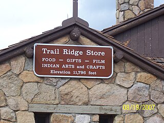
Rocky Mountain National Park's Alpine Visitor Center is located at 11,796 feet above sea level at Fall River Pass, one mile west of the highest point on Trail Ridge Road and four miles east of the Continental Divide at Milner Pass in the U.S. state of Colorado. It is the highest visitor center in the National Park System.

Lincoln National Forest is a unit of the U.S. Forest Service located in southern New Mexico. Established by Presidential Proclamation in 1902 as the Lincoln Forest Preserve, the 1,103,897 acres (4,467.31 km2) forest begins near the Texas border and contains lands in parts of Chaves, Eddy, Lincoln, and Otero, counties. The three Ranger Districts within the forest contain all or part of four mountain ranges, and include a variety of different environmental areas, from desert to heavily forested mountains and sub-alpine grasslands. Established to balance conservation, resource management, and recreation, the lands of the Lincoln National Forest include important local timber resources, protected wilderness areas, and popular recreation and winter sports areas. The forest headquarters is located in Alamogordo, N.M. with local offices in Carlsbad, Cloudcroft, and Ruidoso.

Lumpy Ridge is a prominent series of rocky cliffs, slabs, and buttresses adjacent to and north of the town of Estes Park, Colorado and lies inside of Rocky Mountain National Park and is known for rock climbing.
Fall River Pass is a mountain pass in northern Colorado, in the Rocky Mountains of the western United States. It is located in the Front Range, within Rocky Mountain National Park. The pass is traversed by U.S. Highway 34 on Trail Ridge Road between Granby and Estes Park. However, as at Milner Pass on the Continental Divide, the road does not descend after reaching the pass from the west, but instead continues to climb along a side ridge; thus, neither pass is the high point on Trail Ridge Road, which crests at 12,183 feet (3,713 m) elevation, east of Fall River Pass, still within Rocky Mountain National Park. On the other hand, the old, largely unpaved, and one-way-uphill Fall River Road does have its summit at Fall River Pass, where it joins the modern highway for the descent to the west.

The Skylands Region is a region and marketing area of the State of New Jersey located in the Northern and Central part of the state. It is one of six tourism regions established by the New Jersey State Department of Tourism, the others being the Gateway Region, Greater Atlantic City Region, the Southern Shore Region, the Delaware River Region and the Shore Region. The area officially encompasses Hunterdon, Morris, Somerset, Sussex and Warren counties; the northwestern part of the Passaic County fits in with the Skylands Region, but it is part of the Gateway Region and not the Skylands Region. One could also say that the western most part of Bergen is also part of the skylands. The area features uplifted land, rolling hills and mountains characteristic of North Jersey. The region contains 60,000 acres of state parkland, and a diverse geography filled with lakes, rivers and picturesque hills.
The Horse-Shoe Trail is a 140-mile (230 km) trail that runs from the western edge of Valley Forge National Historical Park westward toward Harrisburg, Pennsylvania. It ends about 15 miles (24 km) northeast of Harrisburg at the Appalachian Trail.

Wild Basin a region in the southeast corner Rocky Mountain National Park in Colorado, United States. The primary entrance is located north of Allenspark off State Highway 7.

Bear Lake is a scenic trailhead and destination in Rocky Mountain National Park. Sitting at an elevation of 9,450 feet (2,880 m), the alpine lake rests beneath the sheer flanks of Hallett Peak and the Continental Divide at 40.31324°N 105.648222°W. Several trails, from easy strolls to strenuous hikes, start from the lake. The Bear Lake Road is open year-round, though it may temporarily close due to adverse weather conditions. An ample parking lot is provided close to the lake. The Bear Lake Road is approximately 10 miles long and starts close to the Beaver Meadows Entrance station of the Rocky Mountains National Park.

The Historic Union Pacific Rail Trail State Park is a recreational trail that follows abandoned railroad lines in Summit County, Utah, United States.

The East Longs Peak Trail, Longs Peak Trail and Keyhole Route-Shelf Trail in Rocky Mountain National Park are listed on the National Register of Historic Places for their significance in the early recreational development of the park. The East Longs Peak Trail was laid out in 1878 by Reverend Elkanah Lamb, long before the designation of the region as parkland. It was extended in 1910 by Enos Mills. The trail leads from the Tahosa Valley, running counterclockwise around Longs Peak and reaching the summit at 14,259 feet.

Grays Peak National Recreation Trail or Grays Peak Trail lies along the Continental Divide of the Americas, part of the Rocky Mountains in the U.S. state of Colorado. It is located in the White River National Forest, Summit County. Grays Peak Trail is south of Interstate 70, east of Keystone Resort and near Montezuma. Grays Peak is adjacent to Torreys Peak. The Grays Peak Trail begins 3 miles above Interstate 70, at 11,200 feet. The summit of Grays Peak is 3.7 miles from the trailhead. Torreys Peak is 4.15 miles from the trailhead, across a saddle from Grays Peak. Grays Peak Trail ascends south through the wetland willows of Stevens Gulch. The trail passes between Stevens Mine on a lower slope of McClellan Mountain,13,587 feet, forming the eastern wall of the valley, and Sterling Silver Group Mine beside the trail to the right on Kelso Mountain, 13,164 feet. The trail climbs 900 feet during the first 1.7 miles to a National Recreation Trail sign indicating that the summit is two miles farther.

Greyrock Mountain National Recreation Trail is a hiking trail in Roosevelt National Forest west of Laporte, Colorado. The trail was constructed by the Civilian Conservation Corps in the 1930s and designated as a National Recreation Trail in 1979.
Mount McConnel National Recreation Trail is a hiking trail in the Cache La Poudre Wilderness of Roosevelt National Forest west of Fort Collins, Colorado. The trail leading from Fort Collins Mountain Park to the summit of Mount McConnel was constructed by the Civilian Conservation Corps in 1936. Designation as a National Recreation Trail was in 1981.

Doughton Park is the largest recreation area the National Park Service manages on the Blue Ridge Parkway. It is located between mile markers 238.5 - 244.7 and at 36° 30' 59.0394" N, -81° 8' 40.92" W. The park is named after North Carolina politician Robert L. Doughton.

Wild Rivers Recreation Area is located in north central New Mexico within the Rio Grande del Norte National Monument. Two rivers that run through the park, the Rio Grande and Red River are National Wild and Scenic Rivers. NM 378 that traverses the recreation area is designated a New Mexico Scenic Byway. Recreational opportunities include whitewater rafting, hiking, biking, fishing and camping.

Mojave Trails National Monument is a large U.S. National Monument located in the state of California between Interstates 15 and 40. It partially surrounds the Mojave National Preserve. It was designated by President Obama on February 12, 2016 along with Castle Mountains National Monument and Sand to Snow National Monument. It is under the control of the Bureau of Land Management.

Upper Beaver Meadows is a montane meadow and visitor attraction in Rocky Mountain National Park in Colorado. The area is known as a good bird-watching spot and its trail leads to a number of other trails within the park. The trails may be used for hiking, snowshoeing, or cross-country skiing.