
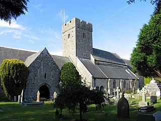
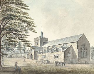
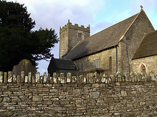
Saint Mael and Saint Sulien's Church is a church located in the town of Corwen in Denbighshire in Wales. It was formerly located in the ancient county of Merionethshire.
Saint Mael and Saint Sulien's Church is a church located in the town of Corwen in Denbighshire in Wales. It was formerly located in the ancient county of Merionethshire.
The church itself dates from the twelfth century and is a single-chambered structure set within a rectangular churchyard, with walls of fourteenth- or fifteenth-century origin. Its baptismal font dates from the twelfth or thirteenth century and the churchyard includes a tomb from the seventeenth century, besides war graves of two soldiers of World War I. [1]

The church is dedicated to St Mael and St Sulien, two Celtic saints of the sixth century, though it has been suggested that an earlier foundation stood on the hill above. Saints Mael and Sulien are said to have been companions of the Breton Saint Cadfan (c. 530-ca. 590), who led a group of missionaries to Western Wales with Saint Tydecho, a cousin, and Saint Cynllo, a friend. [2] They were also accompanied by nine children of Ithel Hael o Lydaw (Baglan, Flewyn, Gredifael, Tanwg, Twrog, Tegai, Trillo, Tecwyn and Llechid), [3] all of whom became saints in the calendar of the Welsh church. One of them, St Trillo, founded a church just outside Corwen at Llandrillo. There was a Saint Sulien or Sulian who was an abbot of Luxulyan, in mid Cornwall, during the sixth century. Sulien is a Welsh variant of the given name "Julian," but has also been interpreted as being derived from the Welsh sul, meaning "sun" + geni, meaning "born," Sulien being the name of a Celtic solar deity.
St Mael and St Sulien's offers services in both English and Welsh.

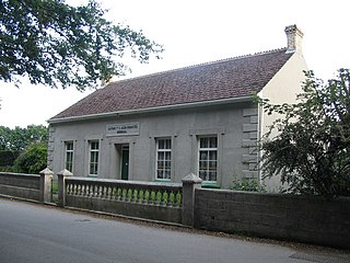
In 1709 the wealthy land-owner and benefactor William Eyton established Coleg y Groes (English: Holy Cross College), attached to St Mael and St Sulien's Church. [4] The College still stands. Eyton established the College as a community of widows, with the intention of providing both an alms house for the residents, and a community of daily prayer attached to the church. Entrance to the College was through the churchyard, with no direct road access (although secondary access is now provided). The College has a central reception and a bakehouse room, beyond which are six individual residences on two storeys (of the one-up, one-down style). Eyton specified that each of the six residences were to be occupied by the widow of a Clerk in holy orders, who must have been a clergyman of the Church of England (the Welsh Anglican church was not yet independent of England in 1750), who had been "in possession of a cure of souls" (in office) within the County of Merioneth at the time of his death. Today the original College building is in good order, and easily accessible by means of a path from the church . It is in private ownership and used as a holiday let business with 2 cottages for rent. It is a grade II* listed building. [5]

Corwen is a town and community in the county of Denbighshire in Wales. Historically, Corwen was part of the county of Merionethshire. Corwen stands on the banks of the River Dee beneath the Berwyn mountains. The town is situated 10 miles (16 km) west of Llangollen and 13 miles (21 km) south of Ruthin. At the 2011 Census, Corwen had a population of 2,325, decreasing slightly from the 2001 population of 2,398, The community, with an area of 69.51 km2 (26.84 sq mi), includes Corwen and the surrounding villages of Carrog, Clawdd Poncen and Glyndyfrdwy. The Office for National Statistics identifies Corwen Built-up area with a 2011 population of and an area of 0.25 km2 (0.097 sq mi).

Rhos-on-Sea is a seaside resort and community in Conwy County Borough, Wales. The population was 7,593 at the 2011 census. It adjoins Colwyn Bay and is named after the Welsh kingdom of Rhos established there in late Roman Britain as a sub-kingdom of Gwynedd. It later became a cantref (hundred).

The culture of Cornwall forms part of the culture of the United Kingdom, but has distinct customs, traditions and peculiarities. Cornwall has many strong local traditions. After many years of decline, Cornish culture has undergone a strong revival, and many groups exist to promote Cornwall's culture and language today.
Luxulyan, also spelt Luxullian or Luxulian, is a village and civil parish in mid Cornwall, England, United Kingdom. The village lies four miles (6.5 km) northeast of St Austell and six miles (10 km) south of Bodmin. The population of the parish was 1,371 in the 2001 census. This had risen to 1,381 at the 2011 census.
St Illtyd's Church is a church complex in Llantwit Major, Vale of Glamorgan, southeast Wales. It is located at the site of the oldest college in the United Kingdom, once believed to have been founded as Côr Tewdws c. AD 395 by the Roman Emperor Theodosius II. It is now generally accepted as having been founded by St. Illtud c. AD 508, from whom it derives its name. The current church building was built in the 11th century by the Normans, with portions being rebuilt in the 13th and 15th centuries. The church building is one of the oldest and best-known parish churches in Wales. It is a grade I listed building, or building of exceptional interest, and has been called both the "Westminster Abbey of Wales" for its unique collection of carved stones and effigies, and "the most beautiful church in Wales."

Llansilin is a village and local government community in Montgomeryshire, Powys, Wales, 5 miles (8 km) west of Oswestry. The community, which includes Llansilin village, a large rural area and the hamlets of Moelfre and Rhiwlas as well as the remote parish of Llangadwaladr, had a population of 648 at the 2001 census, increasing to 698 at the 2011 Census. There is also an electoral ward including the nearby village of Llanrhaeadr-ym-Mochnant with a population of 2,295.

Saint Tysilio was a Welsh bishop, prince and scholar, son of the reigning King of Powys, Brochwel Ysgithrog, maternal nephew of the great Abbot Dunod of Bangor Iscoed and an ecclesiastic who took a prominent part in the affairs of Wales during the distressful period at the opening of the 7th century.

Cubert is a village in Cornwall, England, United Kingdom. It is three miles (5 km) south-southwest of Newquay and is in the civil parish of Cubert.

Erbistock is a village and community in Wrexham County Borough, Wales. The village lies on the banks of the River Dee.
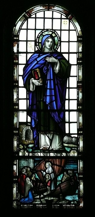
Non was, according to Christian tradition, the mother of Saint David, the patron saint of Wales.

Saint Padarn's Church is a parish church of the Church in Wales, and the largest mediaeval church in mid-Wales. It is at Llanbadarn Fawr, near Aberystwyth, in Ceredigion, Wales, United Kingdom.

Llangeler is a hamlet and community located in north Carmarthenshire, Wales. The name is believed to refer to St. Gelert. Llangeler parish covers a wide area including to the west, the textile village of Drefach Felindre, Waungilwen, Cwmpengraig and to the east, Pont Tyweli which adjoins Llandysul on the Carmarthenshire side of the River Teifi. The population of the parish was 3,222 at the Census of 2001, increasing to 3,427 at the 2011 census.

Maël was a fifth-century Breton saint who lived as a hermit in Wales. He was a follower of Cadfan from Brittany to Wales, ultimately to the Isle of Bardsey. His feast day is 13 May.
Saint Cadfan, sometimes Anglicized as Gideon, was the 6th century founder-abbot of Tywyn and Bardsey, both in Gwynedd, Wales. He was said to have received the island of Bardsey from Saint Einion Frenin, king of Llŷn, around 516 and to have served as its abbot until 542.
St Caffo's Church, Llangaffo is a 19th-century church, in the south of Anglesey, north Wales, about 5 miles (8.0 km) from the county town, Llangefni. It was constructed in 1846 to replace the previous medieval church in the village of Llangaffo. The new building includes a number of monuments from the old church, and has a spire which is a prominent local landmark. The churchyard has part of a stone cross dating from the 9th or 10th century, and some gravestones from the 9th to 11th centuries. It is dedicated to St Caffo, a 6th-century martyr who was killed in the vicinity.
Guilsfield is a village and local government community in Montgomeryshire, Powys, Wales. It lies beside Guilsfield Brook about three miles north of Welshpool. It is located on the B4392 road and a disused branch of the Montgomery Canal starts nearby. The community has an area of 30.01 km2 (11.59 sq mi) and had a population of 1,640 in 2001. rising to 1,727 in 2011. The community includes the villages of Burgedin and Groes-lwyd. The village itself had a population of about 1,220.
Saint Sulien, Sulian, or Silin was the reputed 6th-century founder-abbot of a monastery at Luxulyan in Cornwall. His feast day is 29 July.
Eglwysilan is an ecclesiastical parish and hamlet in Wales, within the community of Aber Valley in the unitary authority of Caerphilly County Borough.
A clas was a native Christian church in early medieval Wales. Unlike later Norman monasteries, which were made up of a main religious building supported by several smaller buildings, such as cloisters and kitchens, a clas was normally a single building. The building was run by a community of clergy and headed by an abod. Clasau were autonomous and were administered locally.

St Silin's Church is a parish church in Llansilin, Powys, Wales. The present building, which has parts dating back to the 13th century, is a Grade I listed building. It stands on a site that has been used by Christian communities since the Dark Ages. The church is dedicated to Saint Silin, now better known as Saint Sulien, the 6th-century founder-abbot of a monastery at Luxulyan in Cornwall.
![]() Media related to Church of St Mael and St Sulien, Corwen at Wikimedia Commons
Media related to Church of St Mael and St Sulien, Corwen at Wikimedia Commons