The River Wensum is a chalk river in Norfolk, England and a tributary of the River Yare, despite being the larger of the two rivers. The river is a biological Site of Special Scientific Interest and Special Area of Conservation.

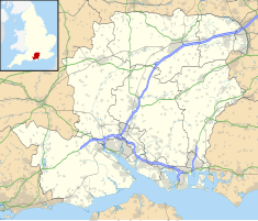
Romsey is a historic market town in the county of Hampshire, England. Romsey was home to the 17th-century philosopher and economist William Petty and the 19th-century British prime minister, Lord Palmerston, whose statue has stood in the town centre since 1857. The town was also home to the 20th-century naval officer and statesman Louis Mountbatten, 1st Earl Mountbatten of Burma, who lived at Broadlands. Romsey Abbey, the largest parish church in Hampshire, dominates the centre of the town. Other notable buildings include a 13th-century hunting lodge, an 18th-century coaching inn and the 19th-century Corn Exchange.

The Darent is a Kentish tributary of the River Thames and takes the waters of the River Cray as a tributary in the tidal portion of the Darent near Crayford, as illustrated by the adjacent photograph, snapped at high tide. 'Darenth' is frequently found in the spelling of the river's name in older books and maps, Bartholomew's "Canal's and River of England" being one example. Bartholomew's Gazetteer (1954) demonstrates that Darent means "clear water" and separately explains the other name. Considering the River Darent runs on a bed of chalk and its springs rise through chalk, this is not surprising. The original purity of the water was a major reason for the development of paper and pharmaceuticals in the area.

Broadlands is an English country house, located in the civil parish of Romsey Extra, near the town of Romsey in the Test Valley district of Hampshire, England. The formal gardens and historic landscape of Broadlands are Grade II* listed on the Register of Historic Parks and Gardens. The house itself is Grade I listed.
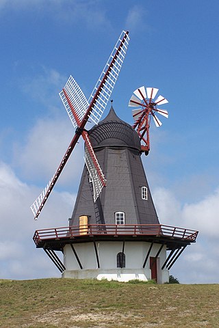
The smock mill is a type of windmill that consists of a sloping, horizontally weatherboarded, thatched, or shingled tower, usually with six or eight sides. It is topped with a roof or cap that rotates to bring the sails into the wind. This type of windmill got its name from its resemblance to smocks worn by farmers in an earlier period.

Rooksbury Mill is an old watermill on the River Anton in Andover, Hampshire, England, and a Grade II listed building. The building and its associated structures are privately owned, but the surrounding land is owned by the Test Valley Borough Council and managed as a local nature reserve.

Hinxton is a village in South Cambridgeshire, England.

The River Len is a river in Kent, England. It rises at a spring in Bluebell Woods to the southeast of the village centre of Lenham 0.6 miles (0.97 km) from the source of the River Great Stour; both rise on the Greensand Ridge. Its length is c10 miles (16 km). It enters the River Medway at Maidstone.
The River Beult is a tributary of the River Medway in South East England.

Great Bircham Windmill is a Grade II listed tower mill in Great Bircham, Norfolk, England.
The Bybrook, also known as the By Brook, is a small river in England. It is a tributary of the Bristol Avon and is some 12 miles (19 km) long. Its sources are the Burton Brook and the Broadmead Brook, which rise in South Gloucestershire at Tormarton and Cold Ashton respectively, and join just north of Castle Combe in Wiltshire. The river has a mean flow rate of 57.25 cubic feet per second (1.621 m3/s) as recorded at Middlehill near Box. A variety of flora and fauna is supported by the river including the endangered white-clawed crayfish. Twenty watermill sites have been identified on the river but none now remain in use.

The Newlin Mill Complex, also referred to as The Newlin Grist Mill, is a water-powered gristmill on the west branch of Chester Creek near Concordville, Pennsylvania was built in 1704 by Nathaniel and Mary Newlin and operated commercially until 1941. During its three centuries of operation, the mill has been known as the Lower Mill, the Markham Mill, the Seventeen-O-Four Mill and the Concord Flour Mill. In 1958 the mill property was bought by E. Mortimer Newlin, restored and given to the Nicholas Newlin Foundation to use as a historical park. Water power is still used to grind corn meal which is sold on site. The park includes five historical buildings, which were added to the National Register of Historic Places in 1983, and 150 acres (61 ha) of natural woodland.
A gristmill grinds cereal grain into flour and middlings. The term can refer to either the grinding mechanism or the building that holds it. Grist is grain that has been separated from its chaff in preparation for grinding.

The Land Yeo is a small river which flows through North Somerset, England.

The Grafton Flour Mill is a former grist mill on the Milwaukee River in Grafton, Wisconsin, United States. The original section was built in 1846 by a group of Yankee farmers as a flour mill and produced flour for many years through a succession of owners.

Gerbestone Manor in West Buckland, Somerset, England was largely rebuilt in the late 16th century, although some fabric from the 13th century house remains. It is a Grade II* listed building.

Many watermills lined the banks of the River Wey, England, from the 17th century due to the river's ability to provide a reliable, year-round flow of water. These mills chiefly ground wheat, often referred to as corn, for flour and oats for animal feed though many were used in the production of other goods such as paper, cloth, leather, wire and gunpowder. The river was home to more mills per mile than anywhere else in Great Britain. The mill situated at Coxes Lock near Addlestone, Surrey, is the largest. There are many mills on the river's principal tributaries, such as the Tillingbourne, the Ock and some mills on the Whitmore Vale stream, Cranleigh Waters and Hodge Brook. The last commercial mill on the Tillingbourne, Botting's Mill at Albury, closed in 1991. Headley Water Mill, on the Wey South branch is still in business. Town Mill, Guildford still has a water turbine driven generator producing electricity for the town.

Romsey Town Hall is a municipal building in the Market Place in Romsey, Hampshire, England. The structure is the meeting place of Romsey Town Council.

Painswick Stream is a small river in Gloucestershire, England. It is a tributary of the River Frome, and flows generally southwards, passing around the village of Painswick and through the town of Stroud. It used to join the Frome at its mouth, but was diverted into the then-derelict Stroudwater Navigation as part of a flood relief scheme in the 1950s. Despite its small size, it has been used to power a significant number of mills, many of which were associated with cloth manufacture until the industry was hit by a series of depressions in the 1820s and 1830s. Some found other uses, being used for grinding corn and for the manufacture of walking sticks and umbrella sticks, another prominent local industry. Many were subsequently demolished, but a number survive which have been granted listed building status.