Salkehatchie River

Last updated

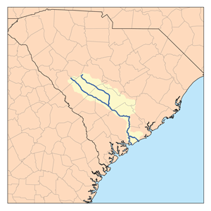
The Salkehatchie River originates near the City of Barnwell, South Carolina and accepts drainage from Turkey Creek and Whippy Swamp before merging with the Little Salkehatchie River to form the Combahee River Basin, which empties into Saint Helena Sound and the Atlantic Ocean. Prior to the confluence, the Little Salkehatchie River accepts drainage from Lemon Creek, Buckhead Creek, and Willow Swamp.
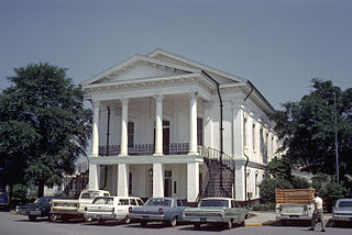
Barnwell, South Carolina City in South Carolina, United States

Barnwell is a city in and county seat of Barnwell County, South Carolina, United States, located along U.S. Route 278. The population was 4,750 at the 2010 census.

The Little Salkehatchie River originates in the Town of Blackville, South Carolina and accepts drainage from Lake Cynthia, Guess Pond, Brooker Pond, Ghants Branch, Halfmoon Branch, and Long Gall Branch. Further downstream, the river accepts drainage from Long Pond, Ben Rice Bay, Colston Branch, and Long Branch. There are a total of 111.7 stream miles and 397.4 acres (1.608 km2) of lake waters in this watershed, all classified freshwater. .

Combahee River river in the United States of America

The Combahee River is a short blackwater river in the southern Lowcountry region of South Carolina formed at the confluence of the Salkehatchie and Little Salkehatchie rivers near the Islandton community of Colleton County, South Carolina. Part of its lower drainage basin combines with the Ashepoo River and the Edisto River to form the ACE Basin The Combahee empties into Saint Helena Sound near Beaufort, which in turn empties into the Atlantic Ocean.

United States General William Tecumseh Sherman of the American Civil War marched his troops across this river and the swamps surrounding it on his way to capture Columbia, South Carolina. [1] This crossing included winning the Battle of Rivers' Bridge, defeating a Confederate force led by Major General Lafayette McLaws.

William Tecumseh Sherman American General, businessman, educator, and author

William Tecumseh Sherman was an American soldier, businessman, educator, and author. He served as a general in the Union Army during the American Civil War (1861–65), for which he received recognition for his outstanding command of military strategy as well as criticism for the harshness of the scorched earth policies he implemented in conducting total war against the Confederate States.

American Civil War Civil war in the United States from 1861 to 1865

The American Civil War was a war fought in the United States from 1861 to 1865, between the North and the South. The Civil War is the most studied and written about episode in U.S. history. Primarily as a result of the long-standing controversy over the enslavement of black people, war broke out in April 1861 when secessionist forces attacked Fort Sumter in South Carolina shortly after Abraham Lincoln had been inaugurated as the President of the United States. The loyalists of the Union in the North proclaimed support for the Constitution. They faced secessionists of the Confederate States in the South, who advocated for states' rights to uphold slavery.

Columbia, South Carolina Capital of South Carolina

Columbia is the capital and second largest city of the U.S. state of South Carolina, with a population estimate of 134,309 as of 2016. The city serves as the county seat of Richland County, and a portion of the city extends into neighboring Lexington County. It is the center of the Columbia metropolitan statistical area, which had a population of 767,598 as of the 2010 United States Census, growing to 817,488 by July 1, 2016, according to 2015 U.S. Census estimates. The name Columbia is a poetic term used for the United States, originating from the name of Christopher Columbus.

The University of South Carolina named its two-year regional campus after the Salkehatchie River. The river flows through Allendale, Bamberg, Barnwell, Colleton and Hampton counties, the same area served by University of South Carolina Salkehatchie.

University of South Carolina university in Columbia, SC

The University of South Carolina is a public research university in Columbia, South Carolina. It has seven satellite campuses throughout the state and its main campus covers over 359 acres (145 ha) in downtown Columbia not far from the South Carolina State House. The university is categorized by the Carnegie Foundation for the Advancement of Teaching as having "highest research activity." It has been ranked as an "up-and-coming" university by U.S. News & World Report, and its undergraduate and graduate International Business programs have ranked among the top three programs in the nation for over a decade. It also houses the largest collection of Robert Burns and Scottish literature materials outside Scotland, and the world's largest Ernest Hemingway collection.

Allendale, South Carolina Town in South Carolina, United States

Allendale is a town in Allendale County, South Carolina, United States. The population was 3,482 at the 2010 census, a decline from 4,052 in 2000. It is the county seat of Allendale County.

Bamberg County, South Carolina county in South Carolina, United States

Bamberg County is a county located in the U.S. state of South Carolina. As of the 2010 census, the population was 15,987, making it the fourth-least populous county in South Carolina. Its county seat is Bamberg.

Related Research Articles

Eastern Continental Divide Hydrological divide in eastern North America

The Eastern Continental Divide or Eastern Divide or Appalachian Divide is a hydrographic divide in eastern North America that separates the easterly Atlantic Seaboard watershed from the westerly Gulf of Mexico watershed. The divide nearly spans the United States from south of Lake Ontario through the Florida peninsula, and consists of raised terrain including the Appalachian Mountains to the north, the southern Piedmont Plateau and lowland ridges in the Atlantic Coastal Plain to the south. Water including rainfall and snowfall, lakes, streams and rivers on the eastern/southern side of the divide drains to the Atlantic Ocean; water on the western/northern side of the divide drains to the Gulf of Mexico. The ECD is one of six continental hydrographic divides of North America which define several drainage basins, each of which drains to a particular body of water.

Buddha, Indiana Unincorporated community in Indiana, United States

Buddha is an unincorporated community in Guthrie Township, Lawrence County, Indiana. The local pronunciation of the name has traditionally been "boo-dee", rhyming with "Judy", though younger residents often pronounce it in line with the religious concept.

Edisto River river in the United States of America

The Edisto River is one of the longest free-flowing blackwater rivers in North America, flowing over 250 meandering miles from its sources in Saluda and Edgefield counties, to its Atlantic Ocean mouth at Edisto Beach, South Carolina. It rises in two main tributaries from springs under the Sandhills region of West Central South Carolina, just to the south of the Piedmont Fall Line. It is the longest and largest river system completely contained by the borders of South Carolina. Its name comes from the Edisto subtribe of the Cusabo Indians.

The Yamasee were a multiethnic confederation of Native Americans who lived in the coastal region of present-day northern coastal Georgia near the Savannah River and later in northeastern Florida.

Battle of Rivers Bridge battle of the Western Theater of the American Civil War

The Battle of Rivers' Bridge was a battle of the American Civil War fought on February 3, 1865.

McPhersonville is an unincorporated community in eastern Hampton County, South Carolina, United States, near the county's borders with Beaufort and Jasper counties. Once an important center of affluence and culture in colonial Prince William Parish, McPhersonville is now little more than a marked location on a secondary road between Yemassee and Early Branch.

Ashepoo River is a short blackwater river in South Carolina, United States. It rises in a confluence of swamps south of Walterboro, flows in a southeast direction and empties into Saint Helena Sound at 32.49°N 80.42389°W. The entire course of the river lies within the boundaries of Colleton County.

Coosawhatchie River river in the United States of America

The Coosawhatchie River (koos-uh-HATCH-ee) is a river in the U.S. state of South Carolina. It rises in Allendale County near the towns of Allendale and Fairfax and accepts drainage from Swallow Savanna, Harters Pond, Little Duck Branch, Duck Branch, Beech Branch (LevyBay), Blood Hill Creek, and Cedar Branch. The channel flows southeast to the Broad River. It is 50 mi/80 km long.

Lake Erie Basin

Lake Erie Basin consists of Lake Erie and surrounding watersheds, which are typically named after the river, creek, or stream that provides drainage into the lake. The watersheds are located in the states of Indiana, Michigan, New York, Ohio, and Pennsylvania in the United States, and in the Province of Ontario in Canada. The basin is part of the Great Lakes Basin and Saint Lawrence River Watershed, which feeds into the Atlantic Ocean. 80% of the lake's water flows in from the Detroit River, with only 9% coming from all of the remaining watersheds combined. A littoral zone serves as the interface between land and lake, being that portion of the basin where the lake is less than 15 feet (4.6 m) in depth.

The University of South Carolina Salkehatchie is a public university in South Carolina with campuses in Allendale and Walterboro. It is one of four regional USC campuses which make up Palmetto College. USC Salkehatchie is accredited by the Southern Association of Colleges and Schools as part of the flagship campus. More than 1100 students attend the University at one of its two sites.

High Hills of Santee

The High Hills of Santee, sometimes known as the High Hills of the Santee, is a long, narrow hilly region in the western part of Sumter County, South Carolina. It has been called "one of the state's most famous areas". The High Hills of Santee region lies north of the Santee River and east of the Wateree River, one of the two rivers that join to form the Santee. It extends north almost to the Kershaw county line and northeasterly to include the former summer resort town of Bradford Springs. Since 1902 the town has been included in Lee County.

The Rapid River is a tributary of the Beckler River in the U.S. state of Washington in the United States. It is 13 miles (21 km) long, with a drainage basin of 41 square miles (106 km2).

Ashepoo Combahee Edisto Basin National Estuarine Research Reserve

The Ashepoo Combahee Edisto Basin National Estuarine Research Reserve is a 140,000-acre (570 km2) reserve area located in the ACE Basin, one of the largest undeveloped estuaries on the Atlantic coast of the United States. It is named for the Ashepoo, Combahee and Edisto Rivers, which flow past cypress swamps, historic plantation houses, old rice fields and tidal marshes to meet at South Carolina’s biologically rich St. Helena Sound.

Chambersburg Township is a township in Iredell County, North Carolina. The 2010 United States Census reported a total population of 11,344.

Bear Creek (Neuse River)

Bear Creek is a tributary of the Neuse River in North Carolina, USA. It drains an area of intensive agriculture, and is heavily polluted with nitrates.

References

  1. "Salkehatchie River Basin". South Carolina Department of Health and Environmental Control . Retrieved 2 November 2006.

U.S. Geological Survey Geographic Names Information System: Salkehatchie River

Coordinates: 32°47′31″N80°52′47″W / 32.79194°N 80.87972°W / 32.79194; -80.87972

Geographic coordinate system Coordinate system

A geographic coordinate system is a coordinate system that enables every location on Earth to be specified by a set of numbers, letters or symbols. The coordinates are often chosen such that one of the numbers represents a vertical position and two or three of the numbers represent a horizontal position; alternatively, a geographic position may be expressed in a combined three-dimensional Cartesian vector. A common choice of coordinates is latitude, longitude and elevation. To specify a location on a plane requires a map projection.