South Korea is made up of 17 first-tier administrative divisions: 6 metropolitan cities, 1 special city, 1 special self-governing city, and 9 provinces, including two special self-governing provinces. These are further subdivided into a variety of smaller entities, including cities, counties, districts, towns, townships, neighborhoods and villages.

The Gyeongjeon Line (Gyeongjeonseon) is a railway line serving South Gyeongsang and South Jeolla Provinces in South Korea. It covers a total of 300.6 km, from Samnangjin Station in Miryang, South Gyeongsang, to Gwangju Songjeong Station in Gwangju, South Jeolla.

Namyangju is a city in Gyeonggi Province, South Korea. To the east is Gapyeong County, to the west is Guri City, and to the north is Pocheon City. Namyangju-si was originally a southern part of Yangju-gun, but was separated into Namyangju-gun in April 1980. In 1995, Migeum-si and Namyangju-gun were merged to form an urban and rural complex. The city hall is located in Geumgok-dong and Dasan-dong, and the administrative districts are 6-eup, 3-myeon, and 7-dong.

Uiwang is a city in Gyeonggi Province, South Korea. It is one of many satellite cities that ring Seoul, making up the Seoul Capital Area. Its largest immediate urban neighbor is Anyang. The low peaks of the Gwangju Mountains shape the local landscape.

Mungyeong is a city in North Gyeongsang Province, South Korea. The local government, economy, and transportation networks are all centered in Jeomchon, the principal town. Mungyeong has a lengthy history, and is known today for its various historic and scenic tourist attractions. The city's name means roughly "hearing good news." Recently, development has been somewhat stagnant with the decline of the coal industry. Since the 1990s, the proportion of people who rely on the tourism industry through Mungyeong Saejae has gradually increased.
Sangju is a city in North Gyeongsang Province, central South Korea. Although Sangju is rather rural, it is very old and was once a key city. Along with Gyeongju, it gives rise to half of the name of the Gyeongsang provinces. Sangju is nicknamed Sam Baek, or "Three Whites", referring to three prominent agricultural products rice, silkworm cocoons, and dried persimmons from the area.

Bonghwa County (Bonghwa-gun) is a county in North Gyeongsang Province, South Korea. It lies inland, at the northern edge of the province, and borders Gangwon province to the north. To the east it is bounded by Yeongyang and Uljin counties, to the south by Andong, and to the west by Yeongju. The county is ringed by the Taebaek and Sobaek Mountains, the highest of which is Taebaeksan (1,566.7m). Because of its mountainous location, Bonghwa has a colder climate than most of the province, with an average annual temperature of 10 °C (50 °F).

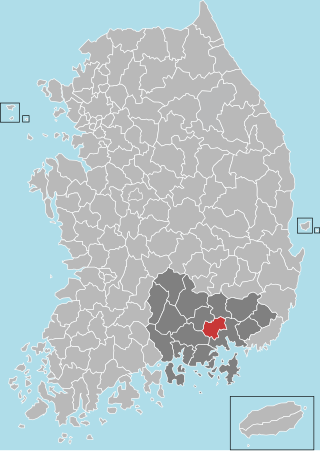
Miryang, formerly also spelled as 推火郡, Milbeol (密伐) and Milseong (密城), is a city in Gyeongsangnam-do Province, South Korea. Its name is originated from the tribal country named Miri midong guk (彌離彌凍國). There are various hypotheses as to the meaning of Miryang, such as Milky Way, Galaxy, dragon's field, The Wheat Field and the watery field. Neighboring cities include Changnyeong to the west, Cheongdo to the north, Ulsan to the east, and Yangsan, Gimhae, and Changwon to the south. The city bird is the Korean magpie, the city tree is the pine, and the city flower is the royal azalea.
Haman County (Haman-gun) is a county in South Gyeongsang Province, South Korea. The local government is seated in Gaya-eup. The county magistrate is Seok Gyu Jin.
Apo-eup is an eup in Gimcheon, Gyeongsangbuk-do, central South Korea. It has an area of 53.48 km². Although it contains several low peaks, the land of Apo-eup also contains a great deal of flat and fertile floodplain; local agriculture is dominated by rice cultivation. The small Gamcheon river runs along the eastern border. As of January 2005, the population is 8,799, and has fallen somewhat since 1995. It is divided among 30 ri.

The Mugunghwa-ho (Korean: 무궁화호) is a class of train operated by Korail, main railway operator of South Korea. Mugunghwa trains are Korail's slowest tier of trains stopping at a number of towns and villages, and operating over a number of lines that are not served by other trains. Journey times are generally twice that of KTX trains and 25% longer than ITX express trains.
The Miryang River is a tributary of the Nakdong River which flows through Miryang City. It rises in Ulsan metropolitan city, on the slopes of Gohyeonsan, and flows for 101.5 kilometers before joining the Nakdong in Miryang's Samnangjin-eup. Its narrower upper reaches are often called the Miryangcheon, or "Miryang Stream."
Cheontaesan (Korean: 천태산) is a 631-meter-high mountain in Gyeongsangnam-do, South Korea, on the border between Miryang and Yangsan cities. It lies near the southern end of the Yeongnam Alps, and looks south across the Nakdong River to Gimhae. Cheontaesan is connected to Geumosan to its north.

Dalseong County (Dalseong-gun) is a gun occupying much of south and western Daegu, South Korea. A largely rural district lying along the Nakdong River, it makes up nearly half of Daegu's total area. It is divided in half by a narrow piece of Dalseo-gu that reaches west to the river.

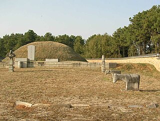
The Yeongnamnu or Yeongnamru is a pavilion on a cliff overlooking the curve of the Miryang River in central Miryang, Gyeongsangnam-do, South Korea. It dates to the Joseon Dynasty and is one of the central cultural treasures of Miryang. The current structure was built in 1884 according to the design of then-magistrate Yi In-jae. During the Joseon period, this was known as one of the three great pavilions of Korea, together with the Chokseongnu in Jinju and the Pubyŏk pavilion in Pyongyang.
Hanam-eup (Korean: 하남읍) is an eup, or large village, in Miryang, Gyeongsangnam-do, South Korea. It stands at the southern tip of Miryang, and looks across the Nakdong River at the northern tips of Gimhae and Changwon.

Gangdong-myeon is a myeon or a township of Gyeongju city in North Gyeongsang Province, South Korea. It is bordered by Pohang on the east and north, Cheonbuk-myeon on the south and Angang-eup on the west. In 2006 its population was 8,705 people, and its area is approximately 81.48 sq kilometers. Its name means "east of the river" although in fact much of it lies north of the Hyeongsan River.

Angang-eup is an eup, or town, and the second-largest subdivision of Gyeongju City. Its 139 square kilometers are home to about 33,300 people and is served by six elementary schools and two joint middle-high schools. Situated next to Gangdong-myeon in the city's northern tip, it is a significant town in its own right. Angang Station is a regular stop on the Donghae Nambu Line. The town center lies on the Hyeongsan River, near where it meets the small Chilpyeongcheon stream. Important local products include rice, apples, and grapes.

Hyeongok-myeon is a myeon or a township in the administrative subdivisions of Gyeongju City, North Gyeongsang province, South Korea. It is bordered by Hyeongsan River, Cheonbuk-myeon and Yonghwang-dong to the east, Bodeok-dong to the south, Geoncheon-eup to the southwest, Seo-myeon to the west and Angang-eup to the north. It has an area of 55.74 square kilometers and is home to 13,658 people. This population is served by three elementary schools, one middle school and one high school.
Bongdam is a town in the city of Hwaseong in South Korea. Covering over 4000 hectares, the town is the focus of a planned community, primarily as a commuter town for the bordering city of Suwon.
