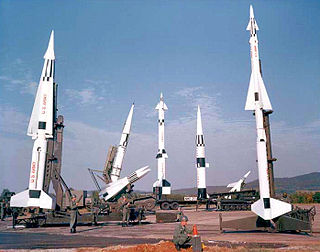
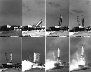
Project Nike was a U.S. Army project, proposed in May 1945 by Bell Laboratories, to develop a line-of-sight anti-aircraft missile system. The project delivered the United States' first operational anti-aircraft missile system, the Nike Ajax, in 1953. A great number of the technologies and rocket systems used for developing the Nike Ajax were re-used for a number of functions, many of which were given the "Nike" name . The missile's first-stage solid rocket booster became the basis for many types of rocket including the Nike Hercules missile and NASA's Nike Smoke rocket, used for upper-atmosphere research.
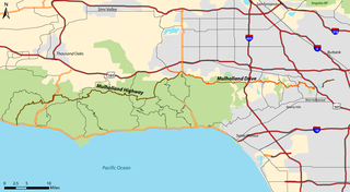
Mulholland Highway is a scenic road in Los Angeles County, California, that runs approximately 50 miles through the western Santa Monica Mountains from near US Route 101 in Calabasas to Highway 1 near Malibu at Leo Carrillo State Park and the Pacific Ocean coast - at the border of Los Angeles and Ventura Counties.
Nichols Canyon is an area in the Hollywood Hills of Los Angeles County, California. It begins at Hollywood Blvd. on its south end and snakes its way north into the hills below Mulholland Drive.

Beverly Hills Post Office (BHPO) is the name given to a section of Los Angeles, California, that lies within the 90210 ZIP code, assigned to the Beverly Hills Post Office. Los Angeles mailing addresses with the ZIP code 90210 are written as "Beverly Hills, CA 90210", though the properties themselves lie outside of the Beverly Hills city limits.

Mandeville Canyon is a small community in the Brentwood neighborhood of Los Angeles. Its center is Mandeville Canyon Road, which begins at Sunset Boulevard and extends north towards Mulholland Drive, though it stops short of Mulholland and there is no automotive route between the two. Mandeville Canyon Road is said to be the longest paved, dead end road in Los Angeles, at over 5 miles (8.0 km). From start to finish, the road gains 1,000 ft (300 m) in elevation.
Holy Martyrs Armenian Elementary and Ferrahian High School is an Armenian-American private school located in the San Fernando Valley of Los Angeles, California, United States. The school has two campuses: the high school, middle school and main offices, which are located in Encino, and the kindergarten and elementary school, which are located in North Hills. The school is part of the Western Prelacy of Armenian Schools, which seeks to promote bilingual education and cultural growth to the city's Armenian community. Instruction is in Armenian and English. The school is accredited by WASC and earned its most recent six-year accreditation in spring, 2007.

Beverly Park, divided into North Beverly Park and South Beverly Park, is a gated community in Los Angeles, California. This wealthy neighborhood is primarily known for its concentration of large houses and for its famous residents. The communities carry a Beverly Hills Post Office address, but are located within the city of Los Angeles. The neighborhood is located between Mulholland Drive and Sunset Boulevard and Coldwater Canyon Drive and Beverly Glen Boulevard, east of the Beverly Glen neighborhood.
Outpost Estates is a neighborhood in the Hollywood Hills of Los Angeles, California, consisting of about 450 homes. It is bordered by Mulholland Drive to the north, Franklin Avenue to the south, Runyon Canyon Park to the west, and Hollywood Heights and the Hollywood Bowl to the east.
Coldwater Canyon is a canyon running perpendicular to and over the central Santa Monica Mountains, in Los Angeles County, California.
The Encino-Tarzana Regional Medical Center consisted of two hospitals, one in Tarzana and the other in Encino, California. Together, the two hospitals had approximately 400 beds. The hospitals were owned by Tenet Healthcare until 2008. Previously, Encino-Tarzana Regional Medical Center was operated as a joint venture between Tenet and HCA, but Tenet bought out its partner's share in 2006 in preparation for divesting it. Encino-Tarzana Regional Medical Center specializes in cardiac services, diabetes care, geriatrics, orthopedics, women's health & maternity care, oncology, rehabilitation medicine, pediatrics and has one of the largest neonatal intensive care units in the Valley.

Marvin Braude Mulholland Gateway Park is a 1,500-acre (6.1 km2) park in the Santa Monica Mountains, with its trailhead at the southern terminus of Reseda Boulevard in Tarzana, Los Angeles, California. The park was named for former Los Angeles City Councilman Marvin Braude, who for more than 30 years led the effort to preserve the Santa Monica Mountains. It is part of the Santa Monica Mountains National Recreation Area.
Oak Knoll is the southernmost neighborhood in Pasadena, California. It is bordered by Oak Knoll Circle to the north, Old Mill Road to the south, South Oak Knoll Avenue and South Oakland Avenue to the west, and the San Marino border to the east.
Launch Complex 576, is a group of rocket launch pads at Vandenberg Air Force Base. The pads were used from 1959 until 1971 to launch SM-65 Atlas missiles. The site was also known as Complex ABRES. Pads in Area 576 include 576-A-1,2,3, 576-B-1,2,3, 576-C, 576-D, 576-E, OSTF-1 and OSTF-2.
Browns Canyon Wash, also known as Browns Canyon Creek, is a 10.3-mile-long (16.6 km) tributary of the Los Angeles River in the Santa Susana Mountains of Los Angeles County and across the western San Fernando Valley of Los Angeles, California.
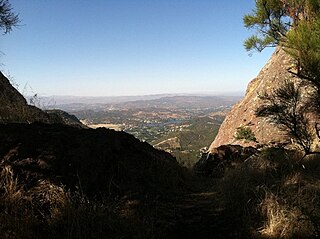
God's Seat is a popular vista and rock formation in Malibu, California, United States, about two miles east of Circle X Ranch in the Santa Monica Mountains National Recreation Area. God's Seat's name derives from its natural throne-like shape at the top of a thousand-foot cliff. It is well-known locally for its scenic views of Lake Sherwood, Sandstone Peak, the Conejo Valley and the Pacific Ocean.
Berkeley Hall School (BHS) is a coed independent school for grades Nursery through 8th located on 66 acres off Mulholland Drive near the 405 Freeway in Los Angeles, California, US. The school is accredited by the California Association of Independent Schools (CAIS) and the Western Association of Schools & Colleges (WASC).
Herb Alpert's Vibrato Grill & Jazz is a jazz club and restaurant on Beverly Glen Circle in Bel Air, Los Angeles, to the south of Mulholland Drive. It was established by Grammy Award-winning jazz trumpeter Herb Alpert. Ariana Savalas is a regular performer at the club.

Mulholland Estates is a gated community in Sherman Oaks, California, U.S.. The main entrance is located at Beverly Glen Boulevard and Mulholland Drive, next to Fossil Ridge Park, and it looks out to the San Fernando Valley. Even though it is not located in the City of Beverly Hills, the zip code is 90210.


