A sandplain is an area where the soil is sand deposited from elsewhere by processes such as wind or ocean, rather than direct weathering of bedrock.
Sandplains are quite flat. There may be dune systems, and given time and the right conditions these may form eolianite ridges, but other than that there is little to give a sandplain any topographical character.
Inland sandplains are often extremely infertile, because the sand is often low in nutrients when deposited, plus the good drainage means any nutrients are rapidly leached away.
Coastal sandplains in intertidal zones like those seen in the Wadden Sea in western Europe for example, are wet with nutrients added continuously, so they can often support a very rich and important fauna of birds, worms, mussels, etc..
In North America, sandplains are often vegetated by pine barrens. In Western Australia, kwongan is the dominant vegetation.
A beach is a landform alongside a body of water which consists of loose particles. The particles composing a beach are typically made from rock, such as sand, gravel, shingle, pebbles, etc., or biological sources, such as mollusc shells or coralline algae. Sediments settle in different densities and structures, depending on the local wave action and weather, creating different textures, colors and gradients or layers of material.
Prairies are ecosystems considered part of the temperate grasslands, savannas, and shrublands biome by ecologists, based on similar temperate climates, moderate rainfall, and a composition of grasses, herbs, and shrubs, rather than trees, as the dominant vegetation type. Temperate grassland regions include the Pampas of Argentina, Brazil and Uruguay, and the steppe of Ukraine, Russia and Kazakhstan. Lands typically referred to as "prairie" tend to be in North America. The term encompasses the area referred to as the Interior Lowlands of Canada, the United States, and Mexico, which includes all of the Great Plains as well as the wetter, hillier land to the east.
A floodplain or flood plain or bottomlands is an area of land adjacent to a river. Floodplains stretch from the banks of a river channel to the base of the enclosing valley, and experience flooding during periods of high discharge. The soils usually consist of clays, silts, sands, and gravels deposited during floods.
A machair is a fertile low-lying grassy plain found on part of the northwest coastlines of Ireland and Scotland, in particular the Outer Hebrides. The best examples are found on North and South Uist, Harris and Lewis.
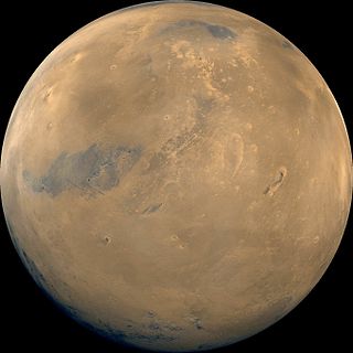
Cerberus is a large "dark spot" located on Mars and named after the mythical dog Cerberus. The arcuate (curved) markings in the upper right are in the Amazonis plains and may be sand drifts. The volcano Elysium Mons, a yellow area north of Cerberus, has several channels radiating from its flanks. The three bright spots, upper left, are volcanoes partially veiled by thin clouds.
The Swan Coastal Plain in Western Australia is the geographic feature which contains the Swan River as it travels west to the Indian Ocean. The coastal plain continues well beyond the boundaries of the Swan River and its tributaries, as a geological and biological zone, one of Western Australia's Interim Biogeographic Regionalisation for Australia (IBRA) regions. It is also one of the distinct physiographic provinces of the larger West Australian Shield division.
Superficial deposits refer to geological deposits typically of Quaternary age. These geologically recent unconsolidated sediments may include stream channel and floodplain deposits, beach sands, talus gravels and glacial drift and moraine. All pre-Quaternary deposits are referred to as bedrock.
The Avon Wheatbelt is a bioregion in Western Australia. It has an area of 9,517,104 hectares. It is considered part of the larger Southwest Australia savanna ecoregion.
Western Australia occupies nearly one third of the Australian continent. Due to the size and the isolation of the state, considerable emphasis has been made of these features; it is the second largest administrative territory in the world, after Yakutia in Russia, despite the fact that Australia is only the sixth largest country in the world by area, and no other regional administrative jurisdiction in the world occupies such a high percentage of a continental land mass. It is also the only first level administrative subdivision to occupy the entire continental coastline in one cardinal direction.
Kwongan is a plant community found in south-western Western Australia. The name is a Bibulman Aboriginal term of wide geographical use defined by Beard (1976) as
...a type of country ...[that is] sandy and is open without timber-sized trees but with a scrubby vegetation. It consists of plains in an Australian sense of open country rather than in a strict sense of flat country. ... there are two principal plant formations in the kwongan, scrub heath and broombush thicket ... both ... are sclerophyll shrublands and possess a certain unity when contrasted with woodland and forest or steppe and succulent steppe communities.
A river mouth is where a river flows into a larger body of water, such as another river, a lake/reservoir, a bay/gulf, a sea, or an ocean. At the river mouth, sediments are often deposited due to the slowing of the current, reducing the carrying capacity of the water. The water from a river can enter the receiving body in a variety of different ways. The motion of a river is influenced by the relative density of the river compared to the receiving water, the rotation of the Earth, and any ambient motion in the receiving water, such as tides or seiches.
Marine habitats are habitats that support marine life. Marine life depends in some way on the saltwater that is in the sea. A habitat is an ecological or environmental area inhabited by one or more living species. The marine environment supports many kinds of these habitats.
The Ogallala Formation is a Miocene to early Pliocene geologic formation in the central High Plains of the western United States and the location of the Ogallala Aquifer. In Nebraska and South Dakota it is also classified as the Ogallala Group. Notably, it records the North American Land Mammal Ages (NALMAs) Hemphillian, Clarendonian, and Barstovian. It also includes an excellent record of grass seeds and other plant seeds, which can be used for biostratigraphic dating within the formation. The Ogallala Formation outcrops of Lake Meredith National Recreation Area preserve fish fossils. Similar specimens from the same unit are found at Alibates Flint Quarries National Monument in Texas.
The Mississippi Alluvial Plain is a Level III ecoregion designated by the Environmental Protection Agency (EPA) in seven U.S. states, though predominantly in Arkansas, Louisiana, and Mississippi. It parallels the Mississippi River from the Midwestern United States to the Gulf of Mexico.
The Eneabba sandplain, or the Eneabba portion of the northern sandplain, is an extension of the Swan Coastal Plain in Western Australia.
The Ecological regions of Quebec are regions with specific types of vegetation and climates as defined by the Quebec Ministry of Forests, Wildlife and Parks. Given the size of this huge province, there is wide variation from the temperate deciduous forests of the southwest to the arctic tundra of the extreme north.
Glaciofluvial deposits or Glacio-fluvial sediments consist of boulders, gravel, sand, silt and clay from ice sheets or glaciers. They are transported, sorted and deposited by streams of water. The deposits are formed beside, below or downstream from the ice. They include kames, kame terraces and eskers formed in ice contact and outwash fans and outwash plains below the ice margin. Typically the outwash sediment is carried by fast and turbulent fluvio-glacial meltwater streams, but occasionally it is carried by catastrophic outburst floods. Larger elements such as boulders and gravel are deposited nearer to the ice margin, while finer elements are carried farther, sometimes into lakes or the ocean. The sediments are sorted by fluvial processes. They differ from glacial till, which is moved and deposited by the ice of the glacier, and is unsorted.
Wurmbea pygmaea is a species of plant in the Colchicaceae family that is endemic to Australia.
This page is based on this Wikipedia article Text is available under the CC BY-SA 4.0 license; additional terms may apply. Images, videos and audio are available under their respective licenses.