Saraktashsky District

Last updated
Saraktashsky District
Саракташский район(Russian)
Saraktashsky District, within Orenburg Oblast.png
Location of Saraktashsky District in Orenburg Oblast
Coordinates: 51°54′N56°24′E / 51.900°N 56.400°E / 51.900; 56.400 Coordinates: 51°54′N56°24′E / 51.900°N 56.400°E / 51.900; 56.400
Sartak.jpg
In Saraktash, the administrative center of Saraktashsky District
Flag of Saraktashsky rayon.png
Flag
Location
Country Russia
Federal subject Orenburg Oblast [1]
Administrative structure (as of December 2014)
Administrative center settlement of  Saraktash [2]
Administrative divisions: [2]
Selsoviets 19
Settlement councils1
Inhabited localities: [2]
Rural localities 77
Municipal structure (as of May 2015)
Municipally incorporated asSaraktashsky Municipal District [3]
Municipal divisions: [3]
Urban settlements0
Rural settlements19
Statistics
Area 3,600 km2 (1,400 sq mi) [4]
Population (2010 Census) 40,145 inhabitants [5]
 Urban0%
 Rural100%
Density 11.15/km2 (28.9/sq mi) [6]
Time zone YEKT (UTC+05:00) [7]
Official website
Saraktashsky District on WikiCommons

Saraktashsky District (Russian : Саракташский райо́н) is an administrative [1] and municipal [3] district (raion), one of the thirty-five in Orenburg Oblast, Russia. It is located in the northeast of the oblast. The area of the district is 3,600 square kilometers (1,400 sq mi). [4] Its administrative center is the rural locality (a settlement) of Saraktash. [2] Population: 40,145 (2010 Census); [5] 42,307(2002 Census); [8] 40,887(1989 Census). [9] The population of Saraktash accounts for 42.9% of the total district's population. [5]

Russian language East Slavic language

Russian is an East Slavic language, which is official in the Russian Federation, Belarus, Kazakhstan and Kyrgyzstan, as well as being widely used throughout Eastern Europe, the Baltic states, the Caucasus and Central Asia. It was the de facto language of the Soviet Union until its dissolution on 25 December 1991. Although, nowadays, over two decades after the breakup of the Soviet Union, Russian is used in official capacity or in public life in all the post-Soviet nation-states, as well as in Israel and Mongolia, the rise of state-specific varieties of this language tends to be strongly denied in Russia, in line with the Russian World ideology.

A raion is a type of administrative unit of several post-Soviet states. The term is from the French "rayon", which is both a type of a subnational entity and a division of a city, and is commonly translated in English as "district".

Contents

Related Research Articles

Abdulino Town in Orenburg Oblast, Russia

Abdulino is a town in Orenburg Oblast, Russia. As of the 2010 Census, its population was 20,173.

Buguruslan Town in Orenburg Oblast, Russia

Buguruslan is a town in Orenburg Oblast, Russia. Population: 49,741 (2010 Census); 53,893 (2002 Census); 54,097 (1989 Census).

Mednogorsk Town in Orenburg Oblast, Russia

Mednogorsk is a town in Orenburg Oblast, Russia. Population: 27,292 (2010 Census); 31,369 (2002 Census); 34,095 (1989 Census).

Kuvandyk Town in Orenburg Oblast, Russia

Kuvandyk is a town in Orenburg Oblast, Russia, located on the Sakmara River at the southern end of the Ural Mountains, 194 kilometers (121 mi) east of Orenburg, the administrative center of the oblast. Population: 26,169 (2010 Census); 28,679 (2002 Census); 28,339 (1989 Census).

Sorochinsk Town in Orenburg Oblast, Russia

Sorochinsk is a town in Orenburg Oblast, Russia, located on the Samara River, 170 kilometers (110 mi) northwest of Orenburg, the administrative center of the oblast. As of the 2010 Census, its population was 29,249.

Yasny, Orenburg Oblast Town in Orenburg Oblast, Russia

Yasny is a town in Orenburg Oblast, Russia, located 502 kilometers (312 mi) southeast of Orenburg, the administrative center of the oblast. Population: 17,363 (2010 Census); 18,545 (2002 Census); 26,587 (1989 Census).

Abdulinsky District District in Orenburg Oblast, Russia

Abdulinsky District is an administrative district (raion), one of the thirty-five in Orenburg Oblast, Russia. It is located in the northwest of the oblast. The area of the district is 1,700 square kilometers (660 sq mi). Its administrative center is the town of Abdulino. As of the 2010 Census, the total population of the district was 10,373.

Akbulaksky District District in Orenburg Oblast, Russia

Akbulaksky District, also known as Ak-Bulaksky District, is an administrative and municipal district (raion), one of the thirty-five in Orenburg Oblast, Russia. The area of the district is 5,000 square kilometers (1,900 sq mi). Its administrative center is the rural locality of Akbulak. Population: 25,606 ; 30,723 (2002 Census); 29,683 (1989 Census). The population of Akbulak accounts for 54.4% of the total district's population.

Asekeyevsky District District in Orenburg Oblast, Russia

Asekeyevsky District is an administrative and municipal district (raion), one of the thirty-five in Orenburg Oblast, Russia. It is located in the northwest of the oblast. The area of the district is 2,400 square kilometers (930 sq mi). Its administrative center is the rural locality of Asekeyevo. Population: 21,050 ; 24,492 (2002 Census); 24,682 (1989 Census). The population of the administrative center accounts for 24.7% of the total district's population.

Gaysky District District in Orenburg Oblast, Russia

Gaysky District is an administrative district (raion), one of the thirty-five in Orenburg Oblast, Russia. It is located in the east of the oblast. The area of the district is 2,900 square kilometers (1,100 sq mi). Its administrative center is the town of Gay. As of the 2010 Census, the total population of the district was 10,331.

Kuvandyksky District District in Orenburg Oblast, Russia

Kuvandyksky District is an administrative district (raion), one of the thirty-five in Orenburg Oblast, Russia. The area of the district is 6,000 square kilometers (2,300 sq mi). Its administrative center is the town of Kuvandyk. Population: 19,545 ; 24,431 (2002 Census); 27,710 (1989 Census).

Novosergiyevsky District District in Orenburg Oblast, Russia

Novosergiyevsky District is an administrative and municipal district (raion), one of the thirty-five in Orenburg Oblast, Russia. It is located in the center of the oblast. The area of the district is 4,500 square kilometers (1,700 sq mi). Its administrative center is the rural locality of Novosergiyevka. Population: 36,322 The population of Novosergiyevka accounts for 37.8% of the district's total population.

Oktyabrsky District, Orenburg Oblast District in Orenburg Oblast, Russia

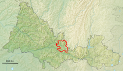
Oktyabrsky District is an administrative and municipal district (raion), one of the thirty-five in Orenburg Oblast, Russia. It is located in the center of the oblast and borders Kuyurgazinsky District of the Republic of Bashkortostan and Sharlyksky District in the north, Tyulgansky District in the east, Sakmarsky District in the south, and Alexandrovsky and Perevolotsky Districts in the west. The area of the district is 2,700 square kilometers (1,000 sq mi). Its administrative center is the rural locality of Oktyabrskoye. As of the 2010 Census, the total population of the district was 20,018, with the population of Oktyabrskoye accounting for 38.5% of that number.

Orenburgsky District District in Orenburg Oblast, Russia

Orenburgsky District is an administrative and municipal district (raion), one of the thirty-five in Orenburg Oblast, Russia. It is located in the center of the oblast. The area of the district is 5,500 square kilometers (2,100 sq mi). Its administrative center is the city of Orenburg. Population: 74,404 ; 65,130 (2002 Census); 58,882 (1989 Census).

Sol-Iletsky District District in Orenburg Oblast, Russia

Sol-Iletsky District is an administrative district (raion), one of the thirty-five in Orenburg Oblast, Russia. It is located in the south of the oblast. The area of the district is 5,100 square kilometers (2,000 sq mi). Its administrative center is the town of Sol-Iletsk,. Population: 25,424 ; 28,425 (2002 Census); 52,939 (1989 Census).

Sorochinsky District District in Orenburg Oblast, Russia

Sorochinsky District is an administrative district (raion), one of the thirty-five in Orenburg Oblast, Russia. It is located in the west of the oblast. The area of the district is 2,800 square kilometers (1,100 sq mi). Its administrative center is the town of Sorochinsk. As of the 2010 Census, the total population of the district was 14,192.

Svetlinsky District District in Orenburg Oblast, Russia

Svetlinsky District is an administrative and municipal district (raion), one of the thirty-five in Orenburg Oblast, Russia. It is located in the east of the oblast. The area of the district is 5,608 square kilometers (2,165 sq mi). Its administrative center is the rural locality of Svetly. Population: 13,876 ; 18,356 (2002 Census); 19,664 (1989 Census). The population of Svetly accounts for 57.6% of the total district's population.

Tyulgansky District District in Orenburg Oblast, Russia

Tyulgansky District is an administrative and municipal district (raion), one of the thirty-five in Orenburg Oblast, Russia. The area of the district is 1,887 square kilometers (729 sq mi). Its administrative center is the rural locality of Tyulgan. As of the 2010 Census, the total population of the district was 19,725, with the population of Tyulgan accounting for 45.4% of that number.

Yasnensky District District in Orenburg Oblast, Russia

Yasnensky District is an administrative district (raion), one of the thirty-five in Orenburg Oblast, Russia. It is located in the southeast of the oblast. The area of the district is 3,500 square kilometers (1,400 sq mi). Its administrative center is the town of Yasny. Population: 5,043 ; 7,440 (2002 Census); 7,867 (1989 Census).

Komarovsky, Orenburg Oblast Settlement in Orenburg Oblast, Russia

Komarovsky is a closed rural locality in Orenburg Oblast, Russia. Population: 8,064 (2010 Census); 8,344 (2002 Census).

References

Notes

  1. 1 2 Law #1370/276-IV-OZ
  2. 1 2 3 4 Государственный комитет Российской Федерации по статистике. Комитет Российской Федерации по стандартизации, метрологии и сертификации. №ОК 019-95 1 января 1997 г. «Общероссийский классификатор объектов административно-территориального деления. Код 53 241», в ред. изменения №278/2015 от 1 января 2016 г.. (State Statistics Committee of the Russian Federation. Committee of the Russian Federation on Standardization, Metrology, and Certification. #OK 019-95 January 1, 1997 Russian Classification of Objects of Administrative Division . Code 53 241, as amended by the Amendment #278/2015 of January 1, 2016. ).
  3. 1 2 3 Law #2367/495-IV-OZ
  4. 1 2 "General Information" (in Russian). Saraktashsky District. Retrieved August 31, 2016.
  5. 1 2 3 Russian Federal State Statistics Service (2011). "Всероссийская перепись населения 2010 года. Том 1" [2010 All-Russian Population Census, vol. 1]. Всероссийская перепись населения 2010 года (2010 All-Russia Population Census) (in Russian). Federal State Statistics Service . Retrieved June 29, 2012.
  6. The value of density was calculated automatically by dividing the 2010 Census population by the area specified in the infobox. Please note that this value is only approximate as the area specified in the infobox does not necessarily correspond to the area of the entity proper or is reported for the same year as the population.
  7. Правительство Российской Федерации. Федеральный закон №107-ФЗ от 3 июня 2011 г. «Об исчислении времени», в ред. Федерального закона №271-ФЗ от 03 июля 2016 г. «О внесении изменений в Федеральный закон "Об исчислении времени"». Вступил в силу по истечении шестидесяти дней после дня официального опубликования (6 августа 2011 г.). Опубликован: "Российская газета", №120, 6 июня 2011 г. (Government of the Russian Federation. Federal Law #107-FZ of June 31, 2011 On Calculating Time , as amended by the Federal Law #271-FZ of July 03, 2016 On Amending Federal Law "On Calculating Time". Effective as of after sixty days following the day of the official publication.).
  8. Russian Federal State Statistics Service (May 21, 2004). "Численность населения России, субъектов Российской Федерации в составе федеральных округов, районов, городских поселений, сельских населённых пунктов – районных центров и сельских населённых пунктов с населением 3 тысячи и более человек" [Population of Russia, Its Federal Districts, Federal Subjects, Districts, Urban Localities, Rural Localities—Administrative Centers, and Rural Localities with Population of Over 3,000](XLS). Всероссийская перепись населения 2002 года [All-Russia Population Census of 2002] (in Russian). Retrieved August 9, 2014.
  9. Demoscope Weekly (1989). "Всесоюзная перепись населения 1989 г. Численность наличного населения союзных и автономных республик, автономных областей и округов, краёв, областей, районов, городских поселений и сёл-райцентров" [All Union Population Census of 1989: Present Population of Union and Autonomous Republics, Autonomous Oblasts and Okrugs, Krais, Oblasts, Districts, Urban Settlements, and Villages Serving as District Administrative Centers]. Всесоюзная перепись населения 1989 года [All-Union Population Census of 1989] (in Russian). Институт демографии Национального исследовательского университета: Высшая школа экономики [Institute of Demography at the National Research University: Higher School of Economics]. Retrieved August 9, 2014.

Sources