Schneekopf

Last updated
Schneekopf

Beerberg und Schneekopf vom Finsterberg aus.jpg

View from the Großer Finsterberg of the Großer Beerberg (l) and the Schneekopf (r, tower)
Highest point
Elevation 978 m above  sea level (NHN) (3,208.7 ft) [1]
Prominence 59.4 m Adler
Isolation 1.6 km  Großer Beerberg
Coordinates 50°39′57″N10°45′52″E / 50.66583°N 10.76444°E / 50.66583; 10.76444 Coordinates: 50°39′57″N10°45′52″E / 50.66583°N 10.76444°E / 50.66583; 10.76444
Geography
Thuringia relief location map.jpg
Red triangle with thick white border.svg
Schneekopf
Parent range Thuringian Forest
Geology
Type of rock Porphyry

The Schneekopf near Gehlberg in the Thuringian county of Ilm-Kreis is 978 m above  sea level (NHN) [1] and thus the second highest peak in the Thuringian Forest after its western neighbour, the Großer Beerberg (983 m). The Adler Saddle between them is only about 59.4 metres lower than the two summits. To the east some distance away is its subpeak, the Sachsenstein (915 m), to the south are the Teufelskreise (967 m) and Fichtenkopf (944 m). The Goldlauterberg (866 m) further south marks the transition to the mountain of Großer Finsterberg (944 m).

Gehlberg Place in Thuringia, Germany

Gehlberg is a municipality in the district Ilm-Kreis, in Thuringia, Germany.

Thuringia State in Germany

Thuringia, officially the Free State of Thuringia, is a state of Germany.

Ilm-Kreis District in Thuringia, Germany

Ilm-Kreis is a district in Thuringia, Germany. It is bounded by the city of Erfurt, the districts of Weimarer Land, Saalfeld-Rudolstadt and Hildburghausen, the city of Suhl, and the districts of Schmalkalden-Meiningen and Gotha. It is named after the river Ilm, flowing through the district.

Contents

Description

The mountain is of volcanic origin and consists of porphyry. It is known for the Schneekopf balls (Schneekopfkugel), balls of porphyry (druse) that occur here that form agate in the interior of crystals. They were formed during a volcanic eruption in the Permian. On the northern slopes of the mountain rises the Wilde Gera stream.

Mountain A large landform that rises fairly steeply above the surrounding land over a limited area

A mountain is a large landform that rises above the surrounding land in a limited area, usually in the form of a peak. A mountain is generally steeper than a hill. Mountains are formed through tectonic forces or volcanism. These forces can locally raise the surface of the earth. Mountains erode slowly through the action of rivers, weather conditions, and glaciers. A few mountains are isolated summits, but most occur in huge mountain ranges.

Porphyry (geology) Textural form of igneous rock with large grained crystals in a fine matrix

Porphyry is a textural term for an igneous rock consisting of large-grained crystals such as feldspar or quartz dispersed in a fine-grained silicate rich, generally aphanitic matrix or groundmass. The larger crystals are called phenocrysts. In its non-geologic, traditional use, the term porphyry refers to the purple-red form of this stone, valued for its appearance.

Druse (geology)

In geology, druse, also known as drusy or druzy, refers to a coating of fine crystals on a rock fracture surface, vein or within a vug or geode.

From the summit plateau there is a good all round view of other summits in the Thuringian Forest and the Rhön mountains, over the Thuringian Basin as far as the Ettersberg near Weimar and of the winter sports resort of Oberhof. In very good visibility, for example during winter inversion weather conditions, the view extends as far as the Brocken in the Harz Mountains, the Schneeberg and the western Ore Mountains. In addition, the Wilde Gera Viaduct (on the A 71), which has a span of 252 metres - the largest arch bridge in Germany, is also visible.

Thuringian Basin

The Thuringian Basin is a depression in the central and northwest part of Thuringia in Germany which is crossed by several rivers, the longest of which is the Unstrut. It stretches about 60 kilometres (37 mi) from north to south and around 120 kilometres (75 mi) from east to west. Its height varies from about 150 to 250 m above sea level (NN).

Oberhof, Germany Place in Thuringia, Germany

Oberhof is a town in the Schmalkalden-Meiningen district of Thuringia, Germany. It is a winter sports center and health resort. With 1,625 inhabitants, it is visited by 144,000 tourists every year (2016). The town got its official city status in 1985.

Brocken Harz mountain in Germany

The Brocken, also sometimes referred to as the Blocksberg, is the highest peak of the Harz mountain range and also the highest peak of Northern Germany; it is located near Schierke in the German state of Saxony-Anhalt between the rivers Weser and Elbe. Although its elevation of 1,141 metres (3,743 ft) is below alpine dimensions, its microclimate resembles that of mountains of about 2,000 m (6,600 ft). The peak above the tree line tends to have a snow cover from September to May, and mists and fogs shroud it up to 300 days of the year. The mean annual temperature is only 2.9 °C (37.2 °F). It is the easternmost mountain in northern Germany; travelling east in a straight line, the next prominent elevation would be in the Ural Mountains in Russia.

Pless-Adlersberg-Beerberg-Eisenberg-Schneekopf-Finsterberg-Hundskopf.jpg
View from the Simmersberg (781 m) of the Schneekopf and the other highest mountains of the Thuringian Forest

Literature

Ludwig Bechstein German writer and fairy tale collector

Ludwig Bechstein was a German writer and collector of folk fairy tales.

International Standard Book Number Unique numeric book identifier

The International Standard Book Number (ISBN) is a numeric commercial book identifier which is intended to be unique. Publishers purchase ISBNs from an affiliate of the International ISBN Agency.

Related Research Articles

Thuringian Forest mountain range in the German state of Thuringia

The Thuringian Forest, is a mountain range in the southern parts of the German state of Thuringia, running northwest to southeast between the valley of the river Werra near Eisenach and the Thuringian-Vogtlandian Slate Mountains. The geographical boundary with the latter range follows approximately a line from Gehren via Großbreitenbach to Schönbrunn near Schleusingen, defined by the rivers Schleuse and Neubrunn on the southwestern slope, and Talwasser, Wohlrose and Möhre on the northeastern slope.

Fichtel Mountains low-mountain range in Bavaria, Germany

The Fichtel Mountains, form a small horseshoe-shaped mountain range in northeastern Bavaria, Germany. They extend from the valley of the Red Main River to the Czech border, a few foothills spilling over into the Czech Republic. They continue in a northeasterly direction as the Ore Mountains, and in a southeasterly direction as the Bohemian Forest. The Fichtel Mountains contain an important nature park, the Fichtel Mountain Nature Park, with an area of 1,020 square kilometres (390 sq mi).

Bundesautobahn 71 federal motorway in Germany

Bundesautobahn 71 is an Autobahn in Germany. It connects the A 38 and Erfurt to the A 70 near Schweinfurt. A further northern extension to the A 14 near Plötzkau has been proposed by the state government of Sachsen-Anhalt.

Großer Beerberg mountain

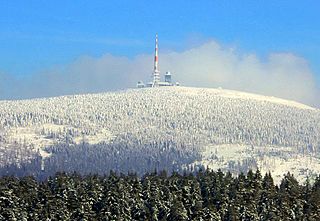
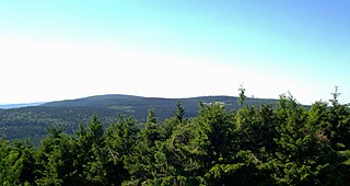
The Großer Beerberg is a mountain located in the Thuringian Forest, Germany, and the highest point in the state of Thuringia. The nearest town is Suhl.

Großer Knollen mountain in the Harz, Germany

The Großer Knollen is a 687.4-metre-high (2,255 ft) mountain in the southwestern part of the Harz in Lower Saxony, Germany.

Großer Auerberg mountain in the Harz, Germany

The Große Auerberg is a hill, 580 metres (1,900 ft) high, in the eastern Harz in the district of Mansfeld-Südharz in the German state of Saxony-Anhalt. It is a so-called double peak with summits that are 580.4 metres high and 580.3 metres high (Josephshöhe), which are about 470 metres apart.

Hohe Acht mountain

At 746.9 m above sea level (NHN), the Hohe Acht is the highest mountain in the Eifel mountains of Germany. It is located on the boundary between the districts of Ahrweiler and Mayen-Koblenz in Rhineland-Palatinate.

Badener Höhe mountain

The Badener Höhe is a mountain in the Northern Black Forest in the German state of Baden-Württemberg. It lies within the borough of Baden-Baden and municipality of Forbach. With a height of 1,002.5 m above sea level (NHN), it is the highest point in the borough of Baden-Baden.

Thuringian Forest Nature Park nature park in Thuringia, Germany

The Thuringian Forest Nature Park is one of the two nature parks in the state of Thuringia, Germany.

Rauhhügel mountain

The Rauhhügel is an 812.9 m high mountain located in the Thuringian Highland, Thuringia (Germany).

Großer Farmdenkopf mountain

At 869 m above sea level (NN), the Großer Farmdenkopf is the highest peak in the Thuringian Highland. It is situated in the county of Sonneberg in the German state of Thuringia.

Hohloh mountain

The Hohloh is a mountain, 988.3 m above sea level (NHN), on the eastern main ridge of the Northern Black Forest in Germany. It lies near the village of Kaltenbronn in the borough of Gernsbach, a town in the county of Rastatt in the German state of Baden-Württemberg. Its summit is the highest point in the borough of Gernsbach and the eastern chain of the Northern Black Forest, the ridge between the rivers Murg and Enz. A mountain pass runs northeast of the summit plateau between the two river valleys passing over the saddle of Schwarzmiss.

The Little Thuringian Forest is a region of mountains and hills that lies southwest of Suhl and northwest of Schleusingen, and extends as far as an imaginary line from Schmeheim via Bischofrod and Gethles to Rappelsdorf. Its length is about 11 km (6.8 mi), its width varies between 1 km (0.62 mi) and 2 km (1.2 mi). Its name is not to be understood in an orographic or geographic sense, but is due to the marked similarity of its bedrock to that of the Thuringian Forest to the north of it.

Gleichberge German mountain range

The Gleichberge, which mainly comprise the Großer and Kleiner Gleichberg, are a small, inselberg-like mountain range, up to 679 m above sea level (NHN), in the southwestern part of the German state of Thuringia. They rise just east of the little ancient town of Römhild in the county of Hildburghausen.

Kleiner Gleichberg mountain in Germany

The Kleiner Gleichberg is the slightly lower of the two Gleichberge mountains, east of the village of Römhild in the country of Grabfeld in the county of Hildburghausen in the German state of Thuringia. The Celtic Oppidum Steinsburg is located on the mountain.

Großer Finsterberg mountain

The Großer Finsterberg is a mountain, 944.1 m above NHN, in the Thuringian Forest not far from the villages of Stützerbach and Schmiedefeld am Rennsteig. It is the third highest peak in the German state of Thuringia.

Simmersberg mountain in Germany

The Simmersberg is a mountain, 780.8 m above sea level (NHN), near Schnett in the municipality of Masserberg) in the county of Hildburghausen in Germany. It is the main summit of a forked mountain chain, which runs along the boundary between the Thuringian Forest and the Thuringian Highland from Masserberg towards the southwest and is bounded by the valleys of the Schleuse and its tributary, the Biber.

Großer Inselsberg mountain in Germany

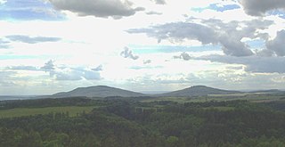
Großer Inselsberg is a mountain in the Thuringian Forest with a height of 916.5 m (3,007 ft) above sea level, located on Rennsteig in the districts of Gotha and Schmalkalden-Meiningen. It is the fourth-highest distinct mountain of Thuringia, after Großer Beerberg, Schneekopf and Großer Finsterberg and forms a landmark that can be viewed in particular from northern and western directions.

Kickelhahn mountain in Germany

Kickelhahn is a mountain in the northern edge of the Central Thuringian Forest in the municipal area of Ilmenau, Germany. Its summit has an altitude of 861.1 metres (2,825 ft) a.s.l.

Großer Hermannsberg mountain

The Großer Hermannsberg is a mountain, 867 metres high, south of the main ridge of the Thuringian Forest in the county of Schmalkalden-Meiningen in Germany.

References

  1. 1 2 Map services of the Federal Agency for Nature Conservation