
Oxleas Wood is one of the few remaining areas of ancient deciduous forest in Eltham in the Royal Borough of Greenwich, in southeast London. Some parts date back over 8,000 years to the end of the last Ice Age, the Younger Dryas. It is part of a larger continuous area of woodland and parkland on the south side of Shooter's Hill: other parts are Jack Wood, Castle Wood, Oxleas Meadows, Falconwood Field, Eltham Common and Eltham Park North. Eltham Park North includes the ancient Shepherdleas Wood. It is also home to Severndroog Castle.
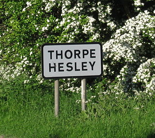
Thorpe Hesley is a village of 4,439 inhabitants in the Metropolitan Borough of Rotherham, South Yorkshire, England, lying east of the M1 motorway at junction 35. The village has been included within the boundaries of Rotherham town since 1894, having previously been divided between the townships of Kimberworth and Wentworth. Historically the village was known for coal mining and nail making. It has an Anglican church, Holy Trinity, built in 1839 chiefly at the cost of Earl Fitzwilliam and the Earl of Effingham.

The River Rom, also known as the River Beam below its confluence with the Ravensbourne, is a tributary of the River Thames in England that flows through east London suburbs surrounding the metropolitan centre of Romford, forming the boundary between the London boroughs of Barking and Dagenham and Havering. The Rom is culverted for a brief midsection as it passes through the centre of Romford.

The Roman Rig is the name given to a series of earthworks to the north east of Sheffield in South Yorkshire, England that are believed to originally have formed a single Dyke running from near Wincobank in Sheffield to Mexborough. Its purpose and date of construction are unknown. Formerly thought to have been a Roman road, modern archaeologists think that it was built either in the 1st century AD by the Brigantian tribes as a defence against the Roman invasion of Britain, or after the 5th century to defend the kingdom of Elmet from the Angles.
Coldfall Wood is an ancient wood in Muswell Hill, North London. It covers an area of approximately 14 hectares and is surrounded by the St. Pancras and Islington Cemetery, the East Finchley public allotments, and the residential streets Creighton Avenue and Barrenger Road. It is the site of the discoveries which first led to the recognition that glaciation had once reached southern England. It was declared a local nature reserve in 2013, and is also a Site of Borough Importance for Nature Conservation, Grade 1.

Highgate Wood is a 28 hectare area of ancient woodland in North London, lying between East Finchley, Highgate Village, and Muswell Hill. It was originally part of the ancient Forest of Middlesex which covered much of London, Hertfordshire and Essex and was mentioned in the Domesday Book. It lies in the London Borough of Haringey, but is owned and managed by the City of London Corporation.

Winterhill School is a mixed secondary school located in Kimberworth, Rotherham, South Yorkshire, England. The school was formed in 2004 by the merger of Old Hall Comprehensive School and the nearby Kimberworth Comprehensive School.

Keppel's Column is a 115-foot (35 m) tower Grade II* listed building between Wentworth and Kimberworth in Rotherham, South Yorkshire, England. Keppel's Column is one of several follies in and around Wentworth Woodhouse park; the others include Hoober Stand and Needle's Eye.

Lower Woods is a 280.1-hectare (692-acre) biological and geological Site of Special Scientific Interest near the village of Wickwar, South Gloucestershire, notified in 1966 and renotified in 1985. The site area has increased at last revision in 1974 to a 284.1-hectare (702-acre) site. The site is a nature reserve managed by the Gloucestershire Wildlife Trust.

Queen's Wood is a 52-acre area of ancient woodland in the London Borough of Haringey, abutting Highgate Wood and lying between East Finchley, Highgate Village, Muswell Hill and Crouch End. It was originally part of the ancient Forest of Middlesex which covered much of London, Hertfordshire and Essex and was mentioned in the Domesday Book and is now one of three Local Nature Reserves in the London Borough of Haringey. It is situated a few minutes' walk away from Highgate tube station.

Hatfield Forest is a 403.2 hectare biological Site of Special Scientific Interest in Essex, three miles east of Bishop's Stortford. It is also a National Nature Reserve and a Nature Conservation Review site. It is owned and managed by the National Trust. A medieval warren in the forest is a Scheduled Monument.

Scholes is a small village in the Rotherham borough of South Yorkshire, England, near the southern boundary of Wentworth Woodhouse, formerly the family seat of the Earls Fitzwilliam. The village is the location of Keppel's Column.

Borsdane Wood is an Ancient Semi Natural Woodland in the Metropolitan Borough of Wigan and Metropolitan Borough of Bolton, Greater Manchester, England. It is believed to have been continuous woodland cover since before 1600 AD and is composed of native tree species that have not obviously been planted. Borsdane Wood was designated a Local Nature Reserve in 1986.

Ruislip Woods is a Site of Special Scientific Interest and national nature reserve covering 726 acres (294 ha) in Ruislip in the London Borough of Hillingdon. The woods became the first national nature reserve in an urban area of England in May 1997, receiving the Green Flag Award in 2006. Ruislip Local Nature Reserve at TQ 090 899 is part of the national nature reserve.

Bills Wood is a Local Nature Reserve and Park located in Shirley, Solihull. It covers an area of approximately 6.6 hectares and consists of a square parcel of woodland surrounded by residential suburbs. To the east the wood is bounded by the school playing fields of Light Hall School. A wide range of plants and animals makes the wood an important urban space, and was therefore granted Local Nature Reserve status in 1991
Shorn Cliff And Caswell Woods is a 69.2-hectare (171-acre) biological Site of Special Scientific Interest in Gloucestershire, notified in 1986. The site is listed in the 'Forest of Dean Local Plan Review' as a Key Wildlife Site (KWS).

Odell Great Wood is an ancient woodland and biological Site of Special Scientific Interest (SSSI) in Odell in Bedfordshire. Located around the centre of the parish of Odell, the site was described by Natural England as "in many respects the best example in Bedfordshire" of wet ash-maple woodland, and in historical sources as "the noblest wood in this county". Being one of the largest of Bedfordshire's ancient woodlands, the wood hosts a wide variety of flora and fauna in its ash, oak and hazel coppice habitat.

Caesar's Camp is an Iron Age hill fort straddling the border of the counties of Surrey and Hampshire in southern England. The fort straddles the borough of Waverley in Surrey and the borough of Rushmoor and the district of Hart, both in Hampshire. Caesar's Camp is a Scheduled Ancient Monument with a list entry identification number of 1007895. It lies approximately 3 kilometres (1.9 mi) north of the town of Farnham, and a similar distance west of Aldershot. The hillfort lies entirely within the Bourley and Long Valley Site of Special Scientific Interest. Caesar's Camp is a multivallate hillfort, a fort with multiple defensive rings, occupying an irregular promontory, with an entrance on the south side. The site has been much disturbed by military activity, especially at the southeast corner. The remains of the hillfort are considered to be of national importance.


