
The city of Billings, Montana is subdivided into 11 sections for geographic and planning purposes.
The city of Billings, Montana is subdivided into 11 sections for geographic and planning purposes.
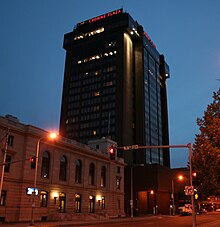
This is the main financial, business, cultural and medical area of Billings and the surrounding areas and is home to several high-rise buildings including Montana's tallest high-rise, the First Interstate Center.
Neighborhoods in this section:
Located Northeast of the Downtown Core, was annexed into the city in the mid-1980s. This area is where the Lake Hills Golf Course.
Neighborhoods in this section:
Northeast is bordered by Roundup Road, Mary Street, Dury Lane and the Yellowstone River. Located northeast of the Heights.
This area is where the Rimrocks rise up above the Yellowstone Valley.
Neighborhoods in this section:
This area is where Central and Terry parks are located. Also where Billings Central Catholic High School is located.
Neighborhoods in this section:
Widely known as the West End or West Side, this is one of the fastest-growing areas in Billings. The West End is the home of Rimrock Mall and Billings West High School, the home of the Bears. The local middle school is Will James, and Meadowlark Elementary is for K-6 graders.
Neighborhoods in this section:
It will soon be the location for a new retail/commercial development called Billings Town Square in which Cabelas will be the anchor tenant.
Neighborhoods in this section:
| | This section is empty. You can help by adding to it. (March 2013) |
This area typically encompasses the area north of Grand Avenue and west of Shiloh. This area tends to be the more affluent part of town.
Neighborhoods in this section:
It is located to the west of the West End - Descro area, and is centered around Shiloh Road, a north–south arterial which in 2008 underwent a major widening project that included the addition of 7 roundabouts. Near the southern part of this section of Billings, south of King Avenue West, a shopping district called Shiloh Crossing was built around the same time, consisting of a movie theater and various restaurants, shops and department stores including Kohl's.
Neighborhoods in this section:
This area is located north of the Airport and west of the Heights and is where the Inner Belt Loop is proposed to link the West End to the Heights.
Neighborhoods in this section:
Lockwood is a Billings suburb located to the east with access to I90. Lockwood has grown to become the largest unincorporated community in the state of Montana and the 16th largest population center in the state. This area is where the Billings Bypass will join the Lockwood area to the Heights via a new interchange on I90.
Shepherd is a Billings suburb located to the northeast off of highway 312. The unincorporated town was named after R.E. Shepherd, a prominent early settler and owner of the Billings Land and Irrigation Company and the Merchants National Bank.

Yellowstone County is the most populous county in the U.S. state of Montana. As of the 2020 census, the population was 164,731. Its county seat is Billings, the state's most populous city. Like the nearby park, Yellowstone County is named after the Yellowstone River which roughly bisects the county, flowing southwest to northeast. The river, in turn, was named for the yellow sandstone cliffs in what is now Yellowstone County.

Billings is the most populous city in the U.S. state of Montana, with a population of 117,116 as of the 2020 census. Located in the south-central portion of the state, it is the seat of Yellowstone County and the principal city of the Billings Metropolitan Area, which had a population of 184,167 in the 2020 census. With one of the largest trade areas in the United States, Billings is the trade and distribution center for much of Montana east of the Continental Divide. Billings is also the largest retail destination for much of the same area. The Billings Chamber of Commerce claims the area of commerce covers more than 125,000 square miles (320,000 km2). In 2009, it was estimated to serve over 500,000 people.

U.S. Route 212 (US 212) is a spur of US 12. It runs for 949 miles (1,527 km) from Yellowstone National Park to Minnesota Highway 62 at Edina, Minnesota. It does not intersect US 12 now, but it once had an eastern terminus at US 12 in St. Paul, Minnesota. US 212 passes through the states of Minnesota, South Dakota, Wyoming, and Montana. It goes through the cities of Watertown, South Dakota and Billings, Montana.

Rimrock is the sheer rock wall at the upper edge of a plateau, canyon, or geological uplift. It may refer to either the rock formation or to the rock itself. Rimrock may be composed of almost any stone—basalt, gneiss, granite, sandstone, etc.—and is frequently layered. Many times it overlays a softer stone which erodes away underneath. American Indians in the West often used cavities found below rimrock to construct dwellings and granaries.
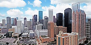
The geographic areas of Houston are generally classified as either being inside or outside Interstate 610, colloquially called "the Loop". The Loop generally encircles the central business district and the "island cities" of West University Place, Southside Place, and a portion of Bellaire.
Billings Metropolitan Transit (MET) is the public transit system in Billings, Montana. MET Transit provides fixed-route and paratransit bus service to the City of Billings Monday-Saturday. The MET is the primary mode of transportation for many citizens of the city. Met serves about 3,000 passengers a day. It currently employs around 200 people. All of MET's buses are accessible by citizens who use wheelchairs and other mobility devices; the buses are wheelchair lift-equipped and accessible to all citizens that are unable to use the stairs. All MET buses are equipped with bike racks for its bike riding passengers.
The list of neighborhoods of Kansas City, Missouri has nearly 240 neighborhoods. The list includes only Kansas City, Missouri and not the entire Kansas City metropolitan area, such as Kansas City, Kansas.
Goose Hollow is a neighborhood in southwest Portland, Oregon. It acquired its distinctive name through early residents' practice of letting their geese run free in Tanner Creek Gulch and near the wooded ravine in the Tualatin Mountains known as the Tanner Creek Canyon. Tanner Creek Gulch was a 20-block-long, 50-foot-deep (15 m) gulch that started around SW 17th and Jefferson and carried the waters of Tanner Creek into Couch Lake. Over a century ago, Tanner Creek was buried 50 feet (15 m) underground, and the Tanner Creek Gulch was filled in. The only remaining part of the hollow is the ravine, Tanner Creek Canyon, carved out by Tanner Creek through which The Sunset Highway carrying US-26 passes and which the Vista Bridge spans, also called the Vista Viaduct.

Neighborhoods in Spokane, Washington are officially grouped by the Spokane City Council into three main city council districts: 1, 2, and 3. Each city council district contains multiple, official neighborhoods that are recognized with a neighborhood council. Informally, neighborhoods are colloquially grouped by local geographical, geological, cultural, or historical features The list of neighborhoods below is organized based on the official designations by the City of Spokane. Unofficial neighborhoods and districts are listed within the official neighborhood in which they are located.
Columbus, the state capital and Ohio's largest city, has numerous neighborhoods within its city limits. Neighborhood names and boundaries are not officially defined. They may vary or change from time to time due to demographic and economic variables.

Interstate 90 (I-90) is an east–west transcontinental Interstate Highway across the northern United States, linking Seattle to Boston. The portion in the state of Montana is 552.46 miles (889.10 km) in length, passing through fourteen counties in central and southern Montana. Due to the large size of Montana, it is the longest segment of I-90 within a single state.

The Rimrocks are geological rimrock sandstone formations that outcrop in sections of Billings, Montana.

A destructive EF2 tornado hit Billings, Montana on Sunday, June 20, 2010. Known as the 2010 Father's Day tornado, the strong tornado was on the ground for about 12 minutes and took the roof off the Rimrock Auto Arena at MetraPark, a 10,000 seat arena, and heavily damaged numerous businesses. The storm was accompanied by high winds and a major hail storm that caused severe damage and flash flooding in the Heights section of the city. It was the first time since 1958 that a significant tornado struck the Downtown Billings area.
The following is a timeline of the history of the city of Billings, Montana, USA.

Lincoln, Nebraska has many neighborhoods, including 45 recognized by Urban Development, City of Lincoln. A list and description of neighborhoods within Lincoln city limits follows.