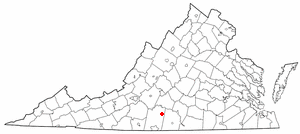
Mount Airy is an unincorporated community in northeastern Pittsylvania County, Virginia, United States. Its altitude is 643 feet (196 m), and it is located at 36°56′35″N79°11′32″W, along State Route 40 between Gretna and Brookneal. It is included in the Danville, Virginia Metropolitan Statistical Area.
Rand McNally is an American technology and publishing company that provides mapping, software and hardware for the consumer electronics, commercial transportation and education markets. The company is headquartered in the Chicago, with a distribution center in Richmond, Kentucky.

The Andreanof Islands are a group of islands in the Aleutian Islands, in southwestern Alaska. They are located at about 52° North and 172°57' to 179°09' West.

North Broad station, known as North Broad Street until 1992, is a SEPTA Regional Rail station in Philadelphia, Pennsylvania. It is located at 2601 North Broad Street in the Cecil B. Moore section of Lower North Philadelphia, and serves the Lansdale/Doylestown Line and the Manayunk/Norristown Line. The station has low-level platforms on the outside tracks, with "mini-high" platforms for wheelchair and ADA accessibility.

Amlia is an island in the Aleutian Islands. It is located near the eastern end of the Andreanof Islands and is situated between Atka Island and Seguam Island.
Amukta is a small yet mountainous island in the Islands of Four Mountains group lying between the Fox Islands and the Andreanof Islands in the Aleutian Islands. The nearest islands to it are Yunaska and Seguam Island; it is separated from Seguam Island by Amukta Pass. The small island of Chagulak lies directly northeast of it. The island reaches a total height of 3,461 feet (1,055 m). The island measures 9 kilometres (5.6 mi) long and 8.3 kilometres (5.2 mi) wide.
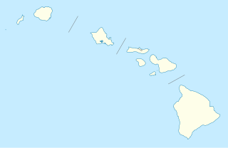
Hōnaunau is an unincorporated community on the island of Hawaii in Hawaii County, Hawaii, United States. It lies just off Hawaii Belt Road on the opposite side of the island from Hilo, the county seat of Hawaii County. Its elevation is 52 feet (16 m). Because the community has borne multiple names, the Board on Geographic Names officially designated it "Honaunau" in 1914 and 1954 before changing to the current spelling in 2000. Although it is unincorporated, it has a post office, with the ZIP code 96726.
Call is an unincorporated community in central Newton County, Texas, United States. It lies along State Highway 87 south of the city of Newton, the county seat of Newton County. Its elevation is 95 feet (29 m), and it is located at 30°36′45″N93°52′28″W. Although Call is unincorporated, it has a post office, with the ZIP code of 75933.
Amukta Pass is a wide strait between the Bering Sea and the North Pacific Ocean in the Aleutian Islands in Alaska. It lies between Amukta Island to the east and Seguam Island to the west.
Fenimore Pass is a strait between the Bering Sea and the North Pacific Ocean in the Aleutian Islands in Alaska. It lies between Oglodak Island to the east and Tagalak Island to the west.

The Plátano River is a river in Honduras which runs through the Río Plátano Biosphere Reserve.
Masparro River is a river of Venezuela. It is part of the Orinoco River basin.
Cunucunuma River is a river of Venezuela. It is part of the Orinoco River basin.
The Burro-Burro River is a river of Guyana.
The Kako River is a river of Guyana.
The Baluarte River, is a river of Mexico in the states of Durango and Sinaloa, traversing 142 km, part of which forms the border between these two states.

Chenoweth is an unincorporated community in Range Township, Madison County, Ohio, United States. It is located at 39°43′52″N83°21′27″W, along Ohio State Route 323 between McClimansville and Range.
Rupert is an unincorporated community in Union Township, Madison County, Ohio, United States. It is located at 39°52′57″N83°21′12″W, at the intersection of Ohio State Route 665 and Glade Run Road, approximately four miles east of London.
Florence is an unincorporated community in Paint Township, Madison County, Ohio, United States. It is located at 39°50′52″N83°32′50″W, along U.S. Route 42 between London and South Charleston.

Arnold is an unincorporated community in Jerome Township, Union County, Ohio, United States. It is located at 40°08′31″N83°15′03″W, along U.S. Route 42, between New California and Plain City.


