Seven Pines, Virginia

Last updated

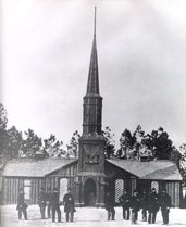
Seven Pines is a community located in the unincorporated town of Sandston in Henrico County, Virginia. Cemetery records state the name is derived from for a group of seven pine trees planted within the national cemetery in 1869 near the intersection of the old Williamsburg-Richmond Stage Road and the Nine Mile Road, however, the name Seven Pines pre-dates the establishment of the cemetery. Earlier maps and records, especially those from the American Civil War, commonly refer to the location as Seven Pines. Today, the surrounding area is still referred to as Seven Pines although it lies within the census-designated place of Sandston and uses Sandston postal addresses.

Unincorporated area Region of land not governed by own local government

In law, an unincorporated area is a region of land that is not governed by a local municipal corporation; similarly an unincorporated community is a settlement that is not governed by its own local municipal corporation, but rather is administered as part of larger administrative divisions, such as a township, parish, borough, county, city, canton, state, province or country. Occasionally, municipalities dissolve or disincorporate, which may happen if they become fiscally insolvent, and services become the responsibility of a higher administration. Widespread unincorporated communities and areas are a distinguishing feature of the United States and Canada. In most other countries of the world, there are either no unincorporated areas at all, or these are very rare; typically remote, outlying, sparsely populated or uninhabited areas.

Sandston, Virginia Census-designated place in Virginia, United States

Sandston is a census-designated place (CDP) in Henrico County, Virginia, United States, just outside the state capital of Richmond. The population as of the 2010 Census was 7,571.

Henrico County, Virginia County in the United States

Henrico County, officially the County of Henrico, is a county in the Commonwealth of Virginia in the United States. As of the 2010 census, the population was 306,935. In 2015, the population was estimated to be 320,717, making it the fifth-most populous county in Virginia and the sixth-most populous county-equivalent in Virginia. Henrico County is included in the Greater Richmond Region. There is no incorporated community within Henrico County, therefore, there is no incorporated county seat either. Laurel, an unincorporated CDP, serves this function.

During the Civil War, several major battles of the Peninsula Campaign in 1862 took place nearby, including the Battle of Seven Pines (as named in Confederate records; the name in Federal records was Fair Oaks for the nearby town of that name), and the smaller engagements of Oak Grove, Golding's Farm, Allen's Farm, Savage's Station, and White Oak Swamp.

Peninsula Campaign Union campaign in the American Civil War

The Peninsula Campaign of the American Civil War was a major Union operation launched in southeastern Virginia from March through July 1862, the first large-scale offensive in the Eastern Theater. The operation, commanded by Maj. Gen. George B. McClellan, was an amphibious turning movement against the Confederate States Army in Northern Virginia, intended to capture the Confederate capital of Richmond. McClellan was initially successful against the equally cautious General Joseph E. Johnston, but the emergence of the more aggressive General Robert E. Lee turned the subsequent Seven Days Battles into a humiliating Union defeat.

Battle of Seven Pines battle of the American Civil War

The Battle of Seven Pines, also known as the Battle of Fair Oaks or Fair Oaks Station, took place on May 31 and June 1, 1862, in Henrico County, Virginia, as part of the Peninsula Campaign of the American Civil War. It was the culmination of an offensive up the Virginia Peninsula by Union Maj. Gen. George B. McClellan, in which the Army of the Potomac reached the outskirts of Richmond.

Fair Oaks is an unincorporated community located in Henrico County, Virginia. Fair Oaks Station was located on the Richmond and York River Railroad and played a role in the Peninsula Campaign in 1862 during the American Civil War. A major battle was fought nearby, known variously as the Battle of Fair Oaks or the Battle of Seven Pines.

The local Seven Pines Elementary School takes it name from the town.

Related Research Articles

Dinwiddie County, Virginia County in the United States

Dinwiddie County is a county located in the Commonwealth of Virginia. As of the 2010 census, the population was 28,001. Its county seat is Dinwiddie.

Franconia, Virginia Census-designated place in Virginia, United States

Franconia is a census-designated place (CDP) in Fairfax County, Virginia, United States. The population was 18,245 at the 2010 census, down from 31,907 in 2000 due to the splitting off of part of it to form the Kingstowne CDP.

Highland Springs, Virginia Census-designated place in Virginia

Highland Springs is a census-designated place (CDP) located in Henrico County, Virginia, United States, 5 miles (8 km) east of Richmond. The population was 15,711 at the 2010 census.

Chickahominy River river in the United States of America

The Chickahominy is an 87-mile-long (140 km) river in the eastern portion of the U.S. state of Virginia. The river, which serves as the eastern border of Charles City County, rises about 15 miles (24 km) northwest of Richmond and flows southeast and south to the James River. The river was named after the Chickahominy Indian tribe who lived near the river when it was claimed by English colonists in 1607. Chickahominy descendants live in Charles City County today.

Battle of Hanover Court House Battle of the American Civil War

The Battle of Hanover Court House, also known as the Battle of Slash Church, took place on May 27, 1862, in Hanover County, Virginia, as part of the Peninsula Campaign of the American Civil War.

Poplar Grove National Cemetery

Poplar Grove National Cemetery is near Petersburg, Virginia, and is managed as part of Petersburg National Battlefield.

Magruder was a small unincorporated town in Virginia near Williamsburg in York County. Settled mostly by African-American freedmen after the American Civil War, it once had its own church, post office, cemetery, lodge, and homes. After this land was acquired for the development of the US military reservation known as Camp Peary, all the residents and businesses were displaced. Magruder is considered extinct and one of the lost towns of Virginia.

Seven Pines National Cemetery

Seven Pines National Cemetery is a national cemetery located in the Seven Pines area of the unincorporated town of Sandston in Henrico County, Virginia. Cemetery records state the name is derived from for a group of seven pine trees planted within the national cemetery in 1869 near the intersection of the old Williamsburg-Richmond Stage Road and the Nine Mile Road, however, the name Seven Pines pre-dates the establishment of the cemetery.

Tabb is an unincorporated community in York County, Virginia, United States, on the Virginia Peninsula. Major roads include U.S. Route 17 and State Route 134.

Savages Station, Virginia

Savage's Station was the wartime name of a supply depot, ammunition dump, field hospital, and command headquarters of the Army of the Potomac during the Peninsula Campaign of the American Civil War. Savage's Station was located in Henrico County, Virginia on what was the Richmond and York River Railroad, however the historical department of the Norfolk Southern Railroad, the railroad track's current owner, has no record that an actual train station or station house ever existed on the property. A farmhouse is known to have been located in a copse of trees on a small knoll next to the railroad track and is visible in several period drawings and photographs made during the war. The house served as the nucleus of a large field hospital during and after the battle of Seven Pines and the Seven Days Battles. The house also functioned as General George B. McClellan's headquarters during the battle of Savage's Station on June 29, 1862. Although the house survived the battle in 1862, it was burned by Federal cavalry under General Philip H. Sheridan in 1864. The house appears to have never been rebuilt, and no trace of it remains today. However, a smokehouse from the 19th century still existed on the property as late as the 1930s when it was photographed during a survey of local historical structures as a project of the Civilian Conservation Corps. The smokehouse fell into ruin and collapsed sometime prior to the 1980s. A small brick-walled cemetery from the 18th century still sits near the former location of the house not far from the railroad track.

Battle of Darbytown and New Market Roads

The Battle of Darbytown and New Market Roads was an engagement between Union and Confederate forces during the American Civil War, which took place on October 7, 1864, in Henrico County, Virginia, as part of the Richmond-Petersburg Campaign.

East End (Richmond, Virginia)

The East End of Richmond, Virginia is the quadrant of the City of Richmond, Virginia, and more loosely the Richmond metropolitan area, east of the downtown.

The Battle of Fair Oaks & Darbytown Road was fought October 27–28, 1864, in Henrico County, Virginia, as part of the Richmond-Petersburg Campaign of the American Civil War.

Seven Pines may refer to the following places in the United States:

Oakfield Cemetery (Wantagh, New York)

Oakfield Cemetery is a 70 X 438 tract of land located on Oakfield Avenue in Wantagh, New York, in the United States. It is covered with grass and lined with sporadically placed oak trees, and is surrounded by residential homes. Backyard fencing of homes also surrounds the land on both sides. The cemetery is now kept locked to keep vandals out. It was first deeded as a cemetery on March 18, 1851, and is noted as the second cemetery in the area to be used by Black residents of Wantagh, many of whom were descendants of freed Jackson family slaves. It is most noted as being the final resting place of four black Civil War soldiers. The Town of Hempstead takes care of this property. It is nicknamed by area residents as "Indian Burying Ground."

Ancell is an extinct town in the northeast corner of Kelso Township, Scott County, in the U.S. state of Missouri. It was named for Pashal Ancell, a pioneer citizen, but was first known as Glenn. It is now part of Scott City, Missouri. Scott City is a consolidation of the formerly separate towns of Fornfelt, Ancell and Illmo, Missouri. These towns arose in association with the building and operation of railroads that passed through the area and all incorporated around the same time. Fornfelt, then known as Edna, incorporated in 1905. Illmo, on the Missouri side of a bridge linking Illinois and Missouri, incorporated in 1906. Ancell, just to the west of Illmo, incorporated in 1907. In 1960, Ancell merged with Fornfelt and formed Scott City. Illmo merged into Scott City in 1980. A post office called Ancell was established in 1912 and remained in operation until this merger. Ancell Cemetery is 5 miles south of Scott City.

References

    Coordinates: 37°31′14″N77°18′10″W / 37.52056°N 77.30278°W / 37.52056; -77.30278

    Geographic coordinate system Coordinate system

    A geographic coordinate system is a coordinate system that enables every location on Earth to be specified by a set of numbers, letters or symbols. The coordinates are often chosen such that one of the numbers represents a vertical position and two or three of the numbers represent a horizontal position; alternatively, a geographic position may be expressed in a combined three-dimensional Cartesian vector. A common choice of coordinates is latitude, longitude and elevation. To specify a location on a plane requires a map projection.