Related Research Articles

The State Library of Western Australia is a research, education, reference and public lending library located in the Perth Cultural Centre in Perth, Western Australia. It is a portfolio agency of the Western Australia Department of Culture and the Arts, and facilitated by the Library Board of Western Australia.

The Shire of Wyndham East Kimberley is one of the four local government areas in the Kimberley region of northern Western Australia, covering an area of 117,514 square kilometres (45,372 sq mi) at Western Australia's northeastern corner. The Shire's seat of government was originally in Wyndham but now in the town of Kununurra, which is home to over half of the Shire's permanent population of around 7,000, while a council office is located at Wyndham.
The Shire of Dowerin is a local government area in the Wheatbelt region of Western Australia, about 160 kilometres (100 mi) northeast of Perth, the state capital. The Shire covers an area of 1,847 square kilometres (713 sq mi) and its seat of government is the town of Dowerin.

Cockburn Central station is a bus and railway station on the Transperth network. It is located at the juncture of the Mandurah and – once completed – Thornlie lines, 20.5 kilometres (12.7 mi) from Perth station inside the median strip of the Kwinana Freeway serving the suburb of Cockburn Central.

The Shire of Waroona is a local government area in the Peel region of Western Australia between Mandurah and Harvey and about 110 kilometres (68 mi) south of Perth, the state capital. The Shire covers an area of about 835 km² (322 mi²) and its seat of government is the town of Waroona.

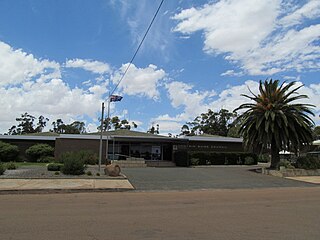
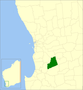
The Shire of Wandering is a local government area in the Wheatbelt region of Western Australia, and, with a population of 444 as at the 2016 census, is one of the nation's smallest. It covers an area of 1,901 square kilometres (734 sq mi) generally to the east of Albany Highway about 120 kilometres (75 mi) south-east of Perth, the state capital. The Shire's seat of government is the town of Wandering.
The Shire of Williams is a local government area in the Wheatbelt region of Western Australia, about 161 kilometres (100 mi) southeast of the state capital, Perth. The Shire covers an area of 2,306 square kilometres (890 sq mi), and its seat of government is the town of Williams.

The Town of Claremont is a local government area in the inner western suburbs of the Western Australian capital city of Perth, located about halfway between the port city of Fremantle and Perth's central business district. The Town covers an area of 4.9 square kilometres (1.9 sq mi), maintains 48 km of roads and 87 km of footpaths, and has a population of approximately 10,000 as at the 2016 Census.

The Shire of Cunderdin is a local government area in the Wheatbelt region of Western Australia, about 105 kilometres (65 mi) west of Merredin and about 155 kilometres (96 mi) east of Perth, the state capital. The Shire covers an area of 1,864 square kilometres (720 sq mi), and its seat of government is the town of Cunderdin.

The Shire of Capel is a local government area in the South West region of Western Australia, taking in the land between the cities of Bunbury and Busselton about 200 kilometres (124 mi) south of the state capital, Perth. The Shire covers an area of 557.6 square kilometres (215.3 sq mi), and its seat of government is the town of Capel.

The Shire of Carnamah is a local government area located in the Mid West region of Western Australia, about 310 kilometres (193 mi) north of Perth, the state capital, and about 181 kilometres (112 mi) south of the city of Geraldton. The Shire covers an area of 2,876 square kilometres (1,110 sq mi) and its seat of government is the town of Carnamah.

The City of Fremantle is a local government area in the south of Perth, Western Australia. The City covers an area of 19.0 square kilometres (7.3 sq mi), and lies about 19 kilometres (12 mi) southwest of the Perth central business district.

The Shire of Sandstone is a local government area in the eastern Mid West region of Western Australia, about 740 kilometres (460 mi) northeast of the state capital, Perth. The Shire covers an area of 32,882 square kilometres (12,696 sq mi), and its seat of government is the town of Sandstone.
The Western Australian Land Information Authority operates under the business name of Landgate.
The Survey Office of Western Australia commenced as early as 1829, making the succeeding agency, the Department of Lands and Surveys, one of the oldest government agencies in Western Australia.
Ajana is a townsite within the Shire of Northampton in Western Australia. It is located at the junction of Ajana-Kalbarri Road and Ajana Back Road, 53 kilometres (33 mi) by road north of Northampton, 61 kilometres (38 mi) by road southwest of Kalbarri, and 531 kilometres (330 mi) west-northwest of Perth in the Mid West region.
WALIS was established by the Western Australian (WA) Government in 1981. It is responsible for coordinating the discovery of, and access to, location-based or geographic data generated by WA Government agencies. WALIS achieves this through partnerships between organisations, projects, committees and working groups; coordinated through Landgate.
The Viewer Access Satellite Television service, or VAST, is a satellite television platform in Australia, providing digital television and radio services to remote and rural areas, as well as viewers in terrestrial black spots. The service using the Optus C1 and Optus D3 satellites. It is partly funded by the Australian Government and managed through a joint-venture between Southern Cross Media and Imparja Television. It is an even more restricted free-to-view replacement for Optus Aurora providing channels which have been absent on the remote service until now. The platform uses only H.264 video encoding and 8PSK, which allows for more lower bit rate channels on the limited transponder space that's available. The EPG uses an MHEG-5 guide instead of the usual more compatible DVB EIT.

Oakley is a locality in the Peel Region of Western Australia. Its local government area is the Shire of Murray.

North Greenbushes is a rural locality and small town of the Shire of Bridgetown–Greenbushes in the South West region of Western Australia.
References
- "About SLIP". Landgate. Retrieved 2008-06-04.