
Middleton is a town in Essex County, Massachusetts, United States. The population was 9,779 at the 2020 census.

North Andover is a town in Essex County, Massachusetts, United States. At the 2020 census the population was 30,915.

Hampstead Heath is an ancient heath in London, spanning 320 hectares. This grassy public space sits astride a sandy ridge, one of the highest points in London, running from Hampstead to Highgate, which rests on a band of London Clay. The heath is rambling and hilly, embracing ponds, recent and ancient woodlands, a lido, playgrounds, and a training track, and it adjoins the former stately home of Kenwood House and its estate. The south-east part of the heath is Parliament Hill, from which the view over London is protected by law.

Boxford is a town in Essex County, Massachusetts, United States. According to the U.S. Census Bureau, the town's population was 8,203 in 2020.

The Wolf River is a 105-mile-long (169 km) alluvial river in western Tennessee and northern Mississippi, whose confluence with the Mississippi River was the site of various Chickasaw, French, Spanish and American communities that eventually became Memphis, Tennessee. It is estimated to be about 12,000 years old, formed by Midwestern glacier runoff carving into the region's soft alluvial soil. It should not be confused with The Wolf River which flows primarily in Middle Tennessee and southern Kentucky. The Wolf River rises in the Holly Springs National Forest at Baker's Pond in Benton County, Mississippi, and flows northwest into Tennessee, before entering the Mississippi River north of downtown Memphis.

T.O. Fuller State Park is a state park in the city of Memphis, Tennessee, USA. It consists of 1,138 acres (461 ha) of mostly forest located in South Memphis on Mitchell Road. It is the only state park within the city limits and is suitable for wildlife.

Haggetts Pond is the reservoir for the town of Andover, Massachusetts, United States. It is located in the western part of the town and also lends its name to a road. The Merrimack River is connected to the pond to add volume to the reservoir.

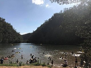
Squantz Pond State Park is a public recreation area located 10 miles (16 km) north of Danbury in the town of New Fairfield, Connecticut. The state park encompasses 172 acres (70 ha) on the southwestern shore of 270-acre (110 ha) Squantz Pond, offering opportunities for boating, swimming, fishing, and hiking. The park is bordered on the west by Pootatuck State Forest and is managed by the Connecticut Department of Energy and Environmental Protection.
Bents Basin is a protected nature reserve and state park near Wallacia, New South Wales, Australia in the Sydney metropolitan area. The lake basin, which formed at the efflux of the Nepean River from the Hawkesbury Sandstone gorge, is a popular swimming hole with a camping area and an education centre used by local school groups. Also featuring a large woodland area and native wildlife, the reserve is the only picnic area along the Nepean River and it is one of the most popular water-based picnic parks in Greater Western Sydney.

Presque Isle State Park is a 3,112-acre (1,259 ha) Pennsylvania State Park on an arching, sandy peninsula that juts into Lake Erie, 4 miles (6 km) west of the city of Erie, in Millcreek Township, Erie County, Pennsylvania, in the United States. The peninsula sweeps northeastward, surrounding Presque Isle Bay along the park's southern coast. It has 13 miles (21 km) of roads, 21 miles (34 km) of recreational trails, 13 beaches for swimming, and a marina. Popular activities at the park include swimming, boating, hiking, biking, and birdwatching.

Polihale State Park is a remote wild beach on the western side of the Hawaiian island of Kauai. It is the most western publicly accessible area in Hawaii, although the privately owned island of Niihau is farther west. The park is miles away from the town of Kekaha, and it can only be reached via a poorly marked, dirt sugarcane road, making a four-wheel drive vehicle preferable. The beach is several miles long, yet only the area known as "Queen's Pond" offers safe swimming.

Dunn State Park is a public recreation area surrounding a 20-acre (8.1 ha) pond in Gardner, Massachusetts. The state park covers 132 acres (53 ha) and is managed by the Department of Conservation and Recreation.
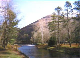
Ole Bull State Park is a 132-acre (53 ha) Pennsylvania state park in Stewardson Township, Potter County, Pennsylvania in the United States. The park is located on Pennsylvania Route 144, 26 miles (42 km) north of Renovo and 18 miles (29 km) south of Galeton. Ole Bull State Park is in the Kettle Creek Valley, and is surrounded by Susquehannock State Forest. The woods surrounding the park are called the Black Forest because of its once dense tree cover.

Lake Cochichewick is a lake in North Andover, Massachusetts that collects water from Weir Hill and other local uplands. Its overflow drains into the Cochichewick River, which joins the Merrimack. Brooks School, a private co-educational prep school, is located on the shores of the lake.

Lake Piru is a reservoir located in Los Padres National Forest and Topatopa Mountains of Ventura County, California, created by the construction in 1955 of the Santa Felicia Dam on Piru Creek, which is a tributary of the Santa Clara River.

Harold Parker State Forest is a publicly owned forest with recreational features encompassing more than 3,300 acres (1,300 ha) in the towns of Andover, North Andover, North Reading, and Middleton, Massachusetts. Ponds, swamps, rolling hills, glacial erratics and rocky outcroppings can be found in the state forest, which features more than 35 miles (56 km) of backwoods roads and trails as well as remnants of 18th-century farming and milling operations. It is managed by the Massachusetts Department of Conservation and Recreation.
Fuller Lake is the body of water with 1.7 acres (0.0069 km2) of surface area in the former Pine Grove Quarry in Cooke Township, Cumberland County, south-central Pennsylvania.

The Taylor Mill State Historic Site is a state park of New Hampshire located in 71-acre Ballard State Forest in Derry, Rockingham County, in the southeast part of the state. The site is created to protect the 1799 mill known as Taylor Up and Down Sawmill. The sawmill is in operation and is open for visitors on weekends during the summer. The site is located on Island Pond Road, east of the downtown of Derry.
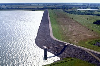
Lake Bardwell is a lake in Ellis County, Texas. The lake was constructed by the United States Army Corps of Engineers in 1965. Lake Bardwell is not used for military operations, and is accessible to the public for recreational purposes; it has seven facilities, but the state public ramp is closed.


