Sheffield, Kansas City

Last updated

Sheffield is a neighborhood of Kansas City, Missouri, United States. [1]

Kansas City, Missouri City in western Missouri

Kansas City is the largest city in the U.S. state of Missouri. According to the U.S. Census Bureau, the city had an estimated population of 491,918 in 2018, making it the 38th most-populous city in the United States. It is the central city of the Kansas City metropolitan area, which straddles the Kansas–Missouri state line. Kansas City was founded in the 1830s as a Missouri River port at its confluence with the Kansas River coming in from the west. On June 1, 1850, the town of Kansas was incorporated; shortly after came the establishment of the Kansas Territory. Confusion between the two ensued and the name Kansas City was assigned to distinguish them soon after.

Missouri U.S. state in the United States

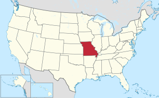
Missouri is a state in the Midwestern United States. With over six million residents, it is the 18th-most populous state of the Union. The largest urban areas are St. Louis, Kansas City, Springfield and Columbia; the capital is Jefferson City. The state is the 21st-most extensive in area. Missouri is bordered by eight states : Iowa to the north, Illinois, Kentucky and Tennessee to the east, Arkansas to the south and Oklahoma, Kansas and Nebraska to the west. In the South are the Ozarks, a forested highland, providing timber, minerals and recreation. The Missouri River, after which the state is named, flows through the center of the state into the Mississippi River, which makes up Missouri's eastern border.

United States Federal republic in North America

The United States of America (USA), commonly known as the United States or America, is a country comprising 50 states, a federal district, five major self-governing territories, and various possessions. At 3.8 million square miles, the United States is the world's third or fourth largest country by total area and is slightly smaller than the entire continent of Europe. With a population of over 327 million people, the U.S. is the third most populous country. The capital is Washington, D.C., and the most populous city is New York City. Most of the country is located contiguously in North America between Canada and Mexico.

A post office called Sheffield was established in 1888, and remained in operation until 1902. [2] The community's name is a transfer from Sheffield, England. [3]

Related Research Articles

Kansas City, Kansas Consolidated city-county in Kansas, United States

Kansas City is the third-largest city in the State of Kansas, the county seat of Wyandotte County, and the third-largest city of the Kansas City metropolitan area. Kansas City, Kansas is abbreviated as "KCK" to differentiate it from Kansas City, Missouri, after which it is named. It is part of a consolidated city-county government known as the "Unified Government". Wyandotte County also includes the independent cities of Bonner Springs, Edwardsville, a portion of Lake Quivira, and the unincorporated area known as Loring. As of the 2010 census, the city had a population of 145,786 residents. It is situated at Kaw Point, which is the junction of the Missouri and Kansas rivers.

North Kansas City, Missouri City in Missouri, United States

North Kansas City is a city in Clay County, Missouri, United States that, despite the similarity in name to its larger counterpart, Kansas City, is an independent municipality part of the Kansas City metropolitan area. The population was 4,208 at the 2010 census. Originally a northern suburb across the Missouri River from Kansas City, it is now almost completely surrounded by Kansas City, which has annexed far to the north of North Kansas City's northern city limits. North Kansas City also adjoins the small municipality of Avondale.

Blue Summit is an unincorporated community lodged between Kansas City and Independence in Jackson County, Missouri, United States.

East Leavenworth is an unincorporated community in Platte County, Missouri, United States. It is located on Route 45, approximately three miles east of Leavenworth, Kansas.

Waldron, Missouri unincorporated community in Missouri

Waldron is an unincorporated community in southwestern Platte County, Missouri, United States. Waldron is not located on a highway, but is approximately two miles southwest of the Interstate 435 and Route 45 interchange. It is about five miles west of the Kansas City city limits.

Faucett is an unincorporated community in southern Buchanan County, Missouri, United States. It is located sixteen miles north of Platte City on Interstate 29 (Missouri)/U.S. Route 71. The community is part of the St. Joseph, MO–KS Metropolitan Statistical Area.

Red Bridge, Kansas City human settlement in Kansas City, Missouri, United States of America

Red Bridge is a neighborhood in South Kansas City. It is centered on the intersection of Red Bridge Road and Holmes Road, on the south side of I-435. Avila University, Minor Park, and the Mount Moriah Cemetery are all located within the Red Bridge neighborhood.

Opolis is an unincorporated community in Crawford County, Kansas, United States.

Ameristar Casino Kansas City

Ameristar Casino Hotel Kansas City is a hotel and casino located on the Missouri River in Kansas City, Missouri. It is owned by Gaming and Leisure Properties and operated by Boyd Gaming.

Kansas City Bolt and Nut Company was a diverse steel parts manufacturing plant in Kansas City, Missouri that through its successors at its peak in the 1950s employed more than 4,500 people.

Kickapoo is an unincorporated community in Kickapoo Township, Leavenworth County, Kansas, USA.

Gashland is a neighborhood of Kansas City, Missouri, United States.

Maple Park is a neighborhood of Kansas City, Missouri, United States.

Nashua is a neighborhood of Kansas City, Missouri, United States.

Courtney is an unincorporated community in Jackson County, in the U.S. state of Missouri.

Hiler is an unincorporated community in Jackson County, in the U.S. state of Missouri.

Holmes Park is a neighborhood of Kansas City, Missouri, United States.

Leeds is a neighborhood of Kansas City, Missouri, United States.

Pink Hill is an unincorporated community in Jackson County, in the U.S. state of Missouri.

Tiffany Springs is a neighborhood of Kansas City, Missouri, United States.

References

  1. U.S. Geological Survey Geographic Names Information System: Sheffield, Kansas City
  2. "Post Offices". Jim Forte Postal History. Retrieved 16 October 2016.
  3. "Jackson County Place Names, 1928–1945 (archived)". The State Historical Society of Missouri. Archived from the original on 24 June 2016. Retrieved 16 October 2016.CS1 maint: BOT: original-url status unknown (link)

Coordinates: 39°06′22″N94°30′39″W / 39.106115°N 94.510787°W / 39.106115; -94.510787

Geographic coordinate system Coordinate system

A geographic coordinate system is a coordinate system that enables every location on Earth to be specified by a set of numbers, letters or symbols. The coordinates are often chosen such that one of the numbers represents a vertical position and two or three of the numbers represent a horizontal position; alternatively, a geographic position may be expressed in a combined three-dimensional Cartesian vector. A common choice of coordinates is latitude, longitude and elevation. To specify a location on a plane requires a map projection.