Sierra Carrascosa

Last updated
Sierra Carrascosa

Sierra Carrascosa34.JPG

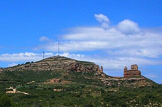
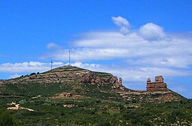
NE end of Sierra Carrascosa with the Guerrero Romano rock formation
Highest point
Elevation 1,214 m (3,983 ft)
Listing List of mountains in Aragon
Coordinates 40°42′15″N0°21′12″W / 40.70417°N 0.35333°W / 40.70417; -0.35333 Coordinates: 40°42′15″N0°21′12″W / 40.70417°N 0.35333°W / 40.70417; -0.35333
Geography
Relief Map of Spain.png
Red triangle with thick white border.svg
Sierra Carrascosa
Spain
Location Maestrazgo. Aragon
Parent range Iberian System, Eastern zone
Geology
Mountain type Sandstone
Climbing
Easiest route From the towns of Villarluengo, Bordón or Castellote

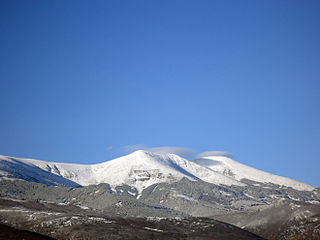
Sierra Carrascosa is a mountain range in the Maestrazgo comarca of Aragon, Teruel Province, Spain. The highest point in the range is Muela Carrascosa (1,214 m). The Guadalope River flows along the NW side of the range. [1]

Maestrazgo, Aragon Comarca in Aragon, Spain

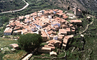
Maestrazgo is a comarca in southeastern Aragon, Spain. Its names derives from the Maestrat/Maestrazgo mountain massif that extends to the east to the Comarques of the Valencian Community Alt Maestrat and Baix Maestrat. The most important town is Cantavieja. It is bordered by the Aragonese comarcas of Andorra-Sierra de Arcos, Cuencas Mineras, Comunidad de Teruel and Bajo Aragón, in the north and in the west and Gúdar-Javalambre in the south, as well as with the Castellón Province in the east. Some municipal terms of this comarca are part of the historical region of Lower Aragon.

Comarcas of Aragon Wikimedia list article

Here is a list of the administrative comarcas (counties) in the autonomous community of Aragon in Spain. They were officially delimited in 1999, with substantial changes over a previously proposed division.

Spain Kingdom in Southwest Europe

Spain, officially the Kingdom of Spain, is a country mostly located on the Iberian Peninsula in Europe. Its territory also includes two archipelagoes: the Canary Islands off the coast of Africa, and the Balearic Islands in the Mediterranean Sea. The African enclaves of Ceuta and Melilla make Spain the only European country to have a physical border with an African country (Morocco). Several small islands in the Alboran Sea are also part of Spanish territory. The country's mainland is bordered to the south and east by the Mediterranean Sea except for a small land boundary with Gibraltar; to the north and northeast by France, Andorra, and the Bay of Biscay; and to the west and northwest by Portugal and the Atlantic Ocean.

Contents

Geography

This 14 km long rocky range is located at the eastern end of the Iberian System and, like neighboring Sierra de Garrucha is characterized by very tight folds. Close to its northeastern end there is a very striking red rock formation known as El Guerrero Romano, "The Roman Soldier". It is a spectacular sight, very visible from A-226 road between Bordón and Castellote. [2]

Fold (geology) fold in geology

A geological fold occurs when one or a stack of originally flat and planar surfaces, such as sedimentary strata, are bent or curved as a result of permanent deformation. Synsedimentary folds are those due to slumping of sedimentary material before it is lithified. Folds in rocks vary in size from microscopic crinkles to mountain-sized folds. They occur singly as isolated folds and in extensive fold trains of different sizes, on a variety of scales.

Bordón Place in Aragon, Spain

Bordón is a municipality located in the province of Teruel, Aragon, Spain. According to the 2010 census the municipality has a population of 141 inhabitants.

Castellote Place in Aragon, Spain

Castellote is a municipality located in the province of Teruel, Aragon, Spain. According to the 2010 census, the municipality has a population of 804 inhabitants.

Villarluengo and Bordón are the most important towns in the vicinity of this range. The range is named after the Quercus coccifera spiny oak (Spanish : carrasca).

Villarluengo Place in Aragon, Spain

Villarluengo is a municipality at the heart of the mountainous Maestrazgo comarca, province of Teruel, Aragon, Spain. According to the 2010 census the municipality has a population of 188 inhabitants.

<i>Quercus coccifera</i> species of plant

Quercus coccifera, the kermes oak, is an oak tree in the Quercus section Cerris. It is native to the Mediterranean region and Northern African Maghreb, south to north from Morocco to France and west to east from Portugal to Cyprus and Turkey, crossing Spain, Italy, Libya, Balkans, and Greece, including Crete. The Kermes Oak was historically important as the food plant of the Kermes scale insect, from which a red dye called crimson was obtained. The etymology of the specific name coccifera is related to the production of red cochineal (crimson) dye and derived from Latin coccum which was from Greek κόκκος, the kermes insect. The Latin -fera means 'bearer'.

Spanish language Romance language

Spanish or Castilian, is a Western Romance language that originated in the Castile region of Spain and today has hundreds of millions of native speakers in the Americas and Spain. It is a global language and the world's second-most spoken native language, after Mandarin Chinese.

See also

Related Research Articles

Province of Teruel Province of Spain

Teruel is a province of Aragon, in the northeast of Spain. The capital is Teruel.

Albarracín Municipality in Aragón, Spain

Albarracín is a Spanish town, in the province of Teruel, part of the autonomous community of Aragon. According to the 2007 census (INE), the municipality had a population of 1075 inhabitants. Albarracín is the capital of the mountainous Sierra de Albarracín Comarca

Berge, Teruel Place in Aragon, Spain

Berge is a little village and municipality in Bajo Aragón, Teruel Province, Aragon, Spain. According to the 2010 census the municipality has a population of 274 inhabitants.

Tronchón Municipality in Aragón, Spain

Tronchón is a town located in the province of Teruel in the autonomous community of Aragon, Spain. The town is near the border with Castellón, a province in the autonomous community of Valencia. It is situated in Teruel’s mountainous area known as Maestrazgo.

Cantavieja Municipality in Aragón, Spain

Cantavieja is a municipality located in the province of Teruel, Aragon, Spain. According to the 2004 census (INE), the municipality had a population of 740 inhabitants. It is the capital of the Maestrazgo comarca.

Villarroya de los Pinares municipality in Aragon, Spain

Villarroya de los Pinares is a municipality located in the Maestrazgo comarca, province of Teruel, Aragon, Spain. According to the 2004 census (INE), the municipality had a population of 190 inhabitants.

Cucalón, Aragon Place in Aragon, Spain

Cucalón is a municipality located in the province of Teruel, Aragon, Spain. According to the 2010 census the municipality has a population of 102 inhabitants. This town gives its name to the Sierra de Cucalón system of mountain ranges.

Molinos, Teruel Place in Aragon, Spain

Molinos is a municipality located in the Maestrazgo comarca, province of Teruel, Aragon, Spain. According to the 2010 census the municipality has a population of 303 inhabitants.

Guadalope river in Aragon, Spain

The Guadalope is a river in Aragon, Spain. It is a tributary of the Ebro.

Morella, Castellón Place in Valencian Community, Spain

Morella is an ancient walled city located on a hill-top in the province of Castellón, Valencian Community, Spain. The town is the capital and administrative centre of the comarca of Els Ports, in the historic Maestrat (Maestrazgo) region.

Sistema Ibérico mountain range

The Iberian System, is one of the major systems of mountain ranges in Spain. It consists of a vast and complex area of mostly relatively high and rugged mountain chains and massifs located in the central region of the Iberian Peninsula, but reaching almost the Mediterranean coast in the Valencian Country in the east.

Lower Aragon Natural region in Spain

Lower Aragon, also known as Tierra Baja, is a natural and historical region in Aragon, Spain. The name "Lower Aragon" refers to the areas of the lowest altitude within the Ebro river basin, but the historical region encompasses only the river basins of several right tributaries of the Ebro River, namely the Matarranya, Guadalope, Regallo, Martín and Aguas, located between the Ebro and the Iberian mountain range.

Sierra de Gúdar mountain in Spain

Sierra de Gúdar is a mountain range in the Gúdar-Javalambre and Maestrazgo comarcas of Aragon and the Alto Mijares comarca of the Valencian Community, Spain. The highest point in the range is Peñarroya (2,019 m).

Sierra de Caballos

Sierra de Caballos or Sierra de los Caballos is a mountain range in the Maestrazgo and Bajo Aragón comarcas of Aragon, Teruel Province, Spain. The highest point in the range is Las Artigas (1,205 m). The Guadalopillo River flows along the northern side of the range.

Luco de Bordón human settlement in Spain

Luco de Bordón is a town in the municipality of Castellote in Spain's Teruel province.

Camino del Cid

The Camino del Cid is a cultural tourist itinerary based on historical personage Rodrigo Díaz and the literary work El Cantar de mio Cid. In both cases they are references of international scope: El Cid, "Castilian hero par excellence, the most exalted knight of medieval Spain" and El Cantar de Mio Cid, "one of the great classics of European literature".

References

  1. "Guadalope" (in Spanish). Gran Enciclopedia Aragonesa. Retrieved 2011-05-24.
  2. El Guerrero Romano