Silesian County

Last updated
Silesian County within Krakow Voivodeship Wojewodztwo krakowskie powiaty 1600-sil.png
  Silesian County within Kraków Voivodeship
Silesian County imposed on a modern map and medieval ducal borders Powiat Slaski pod koniec XVI wieku.png
Silesian County imposed on a modern map and medieval ducal borders

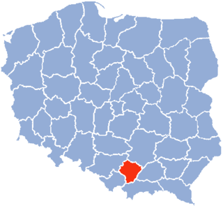
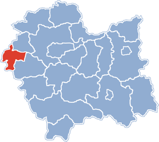
Silesian County (Polish: powiat śląski) was an administrative unit (powiat) of both the Kingdom of Poland and the Polish–Lithuanian Commonwealth. With seats in the towns of Zator and Oświęcim, it was part of Kraków Voivodeship.

Powiat administrative division of Poland

A powiat is the second-level unit of local government and administration in Poland, equivalent to a county, district or prefecture in other countries. The term "powiat" is most often translated into English as "county" or "district".

Kingdom of Poland (1385–1569) Jagiellon kingdom of Poland, 1385-1569

The Kingdom of Poland and the Grand Duchy of Lithuania joined in a personal union established by the Union of Krewo (1385). The union was transformed into a closer one by the Union of Lublin in 1569, which was shortly followed by the end of the Jagiellon dynasty, which had ruled Poland for two centuries.

Polish–Lithuanian Commonwealth Former European state

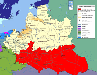
The Polish–Lithuanian Commonwealth – formally, the Crown of the Kingdom of Poland and the Grand Duchy of Lithuania and, after 1791, the Commonwealth of Poland – was a dual state, a bi-confederation of Poland and Lithuania ruled by a common monarch, who was both King of Poland and Grand Duke of Lithuania. It was one of the largest and most populous countries of 16th– to 17th-century Europe. At its largest territorial extent, in the early 17th century, the Commonwealth covered almost 400,000 square miles (1,000,000 km2) and sustained a multi-ethnic population of 11 million.

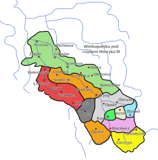
Silesian County was created at the General Sejm in Warsaw, in 1564, when King Sigismund II Augustus merged territories of the Duchy of Zator and the Duchy of Oświęcim, incorporating them into the Kraków Voivodeship of the Polish Crown. [1] The kings retained both ducal titles, and names of both duchies remained in common use. It existed for over 200 years, and was dissolved after the third partition of Poland (1795).

Warsaw City metropolis in Masovia, Poland

Warsaw is the capital and largest city of Poland. The metropolis stands on the Vistula River in east-central Poland and its population is officially estimated at 1.765 million residents within a greater metropolitan area of 3.1 million residents, which makes Warsaw the 8th most-populous capital city in the European Union. The city limits cover 516.9 square kilometres (199.6 sq mi), while the metropolitan area covers 6,100.43 square kilometres (2,355.39 sq mi). Warsaw is an alpha global city, a major international tourist destination, and a significant cultural, political and economic hub. Its historical Old Town was designated a UNESCO World Heritage Site.

Sigismund II Augustus King of Poland and Grand Duke of Lithuania

Sigismund II Augustus was the King of Poland and Grand Duke of Lithuania, the only son of Sigismund I the Old, whom Sigismund II succeeded in 1548.

Duchy of Zator

The Duchy of Zator was one of many Duchies of Silesia.

The total area of Silesian County was 2690 sq. kilometers, and initially consisted of four royal towns (Wadowice, Kęty, Oświęcim and Zator) and one private (Żywiec). In the second half of the 16th century the largest of them was Kęty, with over 1000 inhabitants [2] . Of 188 villages, 38 had over 200 inhabitants [3] . In 1617 a new private town of Zebrzydów, now Kalwaria Zebrzydowska, was founded. In 1723 town rights were granted to Biała, now part of Bielsko-Biała. The town was in the centre of a small German language island that consisted of several other villages. The rest of the County was inhabited by the vast majority of Polish Roman Catholics, although at the turn of the 17th century the county had the highest share of Protestants in the Kraków Voivodeship: 29% of the total number of churches were protestant (mostly reformed), they were present in 34 parishes and their number was estimated at 10 – 15 thousand [4] .

Wadowice Place in Lesser Poland, Poland

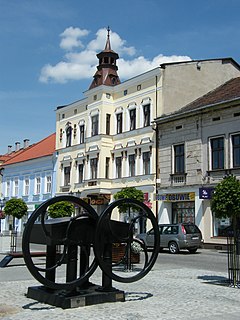
Wadowice is a city in southern Poland, 50 kilometres southwest of Kraków with 19,200 inhabitants (2006), situated on the Skawa river, confluence of Vistula, in the eastern part of Silesian Foothills. Wadowice is best known for being the birthplace of Pope John Paul II.

Kęty Place in Lesser Poland, Poland

Kęty is a town in Oświęcim County, Lesser Poland Voivodeship, Poland with 18,955 inhabitants (2012). The town located in Silesian Foothills dates its earliest document from 1277 when Polish prince of Opole Władysław confirmed sale of the settlement and adoption of Lviv city rights. The town's name comes from the word kąt. The greatest development of the town came under the rule of Jagiellons, when the town became royal property.

Żywiec Place in Silesian, Poland

Żywiec is a town in south-central Poland with 32,242 inhabitants. Between 1975 and 1998, it was located within the Bielsko-Biała Voivodeship, but has since become part of the Silesian Voivodeship.

The largest Jewish community lived since the late 16th century in Oświęcim, when they established the first Qahal, built a Synagogue and opened a Jewish school [5] . In years 1747–1749 the deanery of Oświęcim counted 2462 Jews [6] .

The Qahal was a theocratic organizational structure in ancient Israelite society according to the Hebrew Bible. In later centuries, Qahal was the name of the autonomous governments of Ashkenazi Jews until being abolished in the 1840s.

Synagogue Jewish or Samaritan house of prayer

A synagogue, is a Jewish or Samaritan house of worship.

Footnotes

  1. Radosław Truś (2008). Beskid Mały: przewodnik. Oficyna Wydawnicza "Rewasz". p. 35. ISBN   978-83-89188-77-9.
  2. Województwo krakowskie w drugiej połowie XVI wieku, 2008, p. 71-75
  3. Województwo krakowskie w drugiej połowie XVI wieku, 2008, p. 82
  4. Krzysztof Koźbiał (1999). Wadowice na tle osad starostwa zatorskiego: zarys dziejów do 1772 roku (PDF). Wadoviana: przegląd historyczno-kulturalny. 3. p. 17.
  5. Rafał Malik (1994). Oświęcim. Charakterystyka układu lokacyjnego miasta oraz jego rozwój przestrzenny w okresie średniowiecza (PDF) (in Polish). Kraków.
  6. Marian Surdacki (1983). Stosunki wyznaniowe w diecezji krakowskiej w połowie XVIII wieku na podstawie wizytacj i tabel biskupa A.S. Załuskiego. Roczniki Nauk Społecznych (in Polish). XI. pp. 115, 128, 132.

Related Research Articles

Lesser Poland Voivodeship Voivodeship in Poland

Lesser Poland Voivodeship or Lesser Poland Province, also known as Małopolska Voivodeship or Małopolska Province, is a voivodeship (province), in southern Poland. It has an area of 15,108 square kilometres (5,833 sq mi), and a population of 3,267,731 (2006).

Oświęcim Place in Lesser Poland, Poland

Oświęcim is a town in the Lesser Poland province of southern Poland, situated 50 kilometres (31 mi) west of Kraków, near the confluence of the Vistula (Wisła) and Soła rivers. The town is commonly known for being the site of the Auschwitz concentration camp during World War II when Poland was under the control of Nazi Germany.

Bielsko-Biała Voivodeship

Bielsko-Biala Voivodeship was a unit of administrative division and local government in Poland from 1975 to 1998, superseded by Silesian Voivodeship and Lesser Poland Voivodeship. Its capital city was Bielsko-Biała.

Kraków Voivodeship

Kraków Voivodeship, refers to several historical Voivodeships of Poland in the surrounding regions, with the city of Kraków as its capital.

Andrychów Place in Lesser Poland, Poland

Andrychów(listen) is the largest town in Wadowice County in southern Poland, in Little Beskids, in historical region Lesser Poland, with 22,257 inhabitants as of 2006. It has been situated in the Lesser Poland Voivodeship since 1999. Previously, it was located in Bielsko-Biała Voivodeship (1975–98). The mayor of Andrychów is Tomasz Żak. Andrychów is home to a sports club Beskid, established in 1919. Andrychów lies on the river Wieprzówka.

Zator Place in Lesser Poland, Poland

Zator is an old town on the Skawa river within Oświęcim County, Lesser Poland Voivodeship in southern Poland. From 1975 to 1998 it belonged to the Bielsko-Biała Voivodeship. It is the administrative seat of the Gmina Zator. According to data from December 31, 2008, Zator was inhabited by 4779 people.

Oświęcim County County in Lesser Poland, Poland

Oświęcim County is a unit of territorial administration and local government (powiat) in Lesser Poland Voivodeship, southern Poland. It came into being on January 1, 1999, as a result of the Polish local government reforms passed in 1998. Its administrative seat and largest town is Oświęcim, which lies 51 kilometres (32 mi) west of the regional capital Kraków. The county contains four other towns: Kęty, 17 km (11 mi) south of Oświęcim, Brzeszcze, 9 km (6 mi) south-west of Oświęcim, Chełmek, 8 km (5 mi) north of Oświęcim, and Zator, 16 km (10 mi) east of Oświęcim.

Kraków Voivodeship (1919–1939)

Kraków Voivodeship - a unit of administrative division and local government in Poland in years 1919–1939. Back then, it covered a big chunk of southern part of the country, including such cities as Kraków, Jaworzno and Tarnów. Capital city: Kraków.

Duchy of Oświęcim

The Duchy of Oświęcim, or the Duchy of Auschwitz, was one of many Duchies of Silesia, formed in the aftermath of the fragmentation of Poland.

Kraków Voivodeship (14th century – 1795)

Kraków Voivodeship 1300–1795 – a unit of administrative division and local government in the Kingdom of Poland from the 14th century to the partitions of Poland in 1772–1795. Located in the southwestern corner of the country, it was part of the Little Poland province.

Bulowice Village in Lesser Poland, Poland

Bulowice is a village in the administrative district of Gmina Kęty, within Oświęcim County, Lesser Poland Voivodeship, in southern Poland. It lies approximately 8 kilometres (5 mi) south of Kęty, 25 km (16 mi) south of Oświęcim, and 56 km (35 mi) south-west of the regional capital Kraków.

Malec, Lesser Poland Voivodeship Village in Lesser Poland, Poland

Malec is a village in the administrative district of Gmina Kęty, within Oświęcim County, Lesser Poland Voivodeship, in southern Poland. It lies approximately 5 kilometres (3 mi) north-east of Kęty, 13 km (8 mi) south of Oświęcim, and 52 km (32 mi) west of the regional capital Kraków.

Witkowice, Lesser Poland Voivodeship Village in Lesser Poland, Poland

Witkowice is a village in the administrative district of Gmina Kęty, within Oświęcim County, Lesser Poland Voivodeship, in southern Poland. It lies approximately 5 kilometres (3 mi) east of Kęty, 16 km (10 mi) south of Oświęcim, and 50 km (31 mi) west of the regional capital Kraków.

Lesser Poland Province of the Polish Crown

Lesser Poland Province was an administrative division of the Crown of the Kingdom of Poland from 1569 until 1793 and the biggest province of the Polish-Lithuanian Commonwealth. The name of the province comes from historic land of Lesser Poland. The name of the province did not imply its size, but rather seniority.

Lipnik, Bielsko-Biała Osiedle of Bielsko-Biała in Silesian, Poland

Lipnik is a osiedle (district) of Bielsko-Biała, Silesian Voivodeship, southern Poland. The osiedle has an area of 8.9317 km2 and on December 31, 2006 had 5,885 inhabitants.

Mikuszowice District of Bielsko-Biała in Silesian, Poland

Mikuszowice is an informal dzielnica (district) of Bielsko-Biała, Silesian Voivodeship, Poland. It is located in the southern part of the city on both banks of the Biała River, the historical border river between Silesia and Lesser Poland; and from the mid-15th century to 1772, also the states of Poland and Bohemia.

Komorowice, Bielsko-Biała District of Bielsko-Biała in Silesian, Poland

Komorowice is the northernmost part of Bielsko-Biała, Silesian Voivodeship, southern Poland. It is located on both banks of the Biała River, the historical border river between Silesia and Lesser Poland, and from the mid-15th century to 1772, also the states of Poland and Bohemia.

Pernus coat of arms

Pernus Silesian coat of arms from the 13th century by Frederick II, Holy Roman Emperor, from ca. 1442 in Poland. In 1589 Paweł (Paul) Pernus, vogt of the Royal Court received indygenat (grant), of the Kingdom of Poland and the Grand Duchy of Lithuania.

References